Estimated Value: $821,000 - $867,853
4
Beds
3
Baths
3,683
Sq Ft
$229/Sq Ft
Est. Value
About This Home
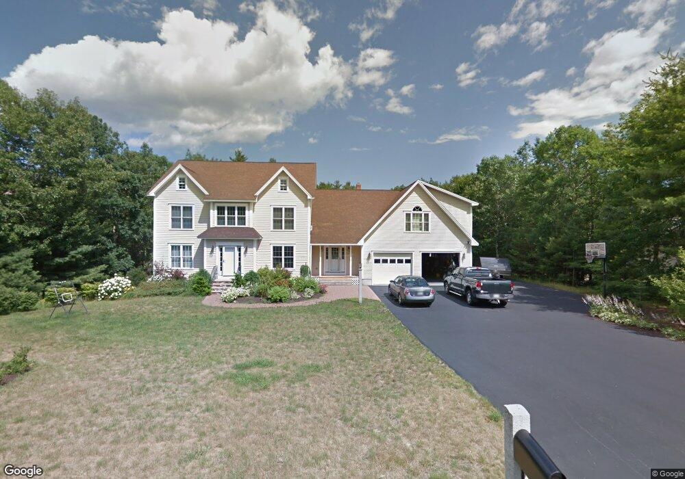
This home is located at 130 Natanis Ridge, Wells, ME 04090 and is currently estimated at $844,463, approximately $229 per square foot. 130 Natanis Ridge is a home located in York County with nearby schools including Wells Elementary School, Wells Junior High School, and Wells High School.
Ownership History
Date
Name
Owned For
Owner Type
Purchase Details
Closed on
Feb 17, 2023
Sold by
Taylor Debra D and Taylor Michael A
Bought by
Dyson Thomas E and Dyson Veronica B
Current Estimated Value
Home Financials for this Owner
Home Financials are based on the most recent Mortgage that was taken out on this home.
Original Mortgage
$540,000
Outstanding Balance
$523,057
Interest Rate
6.33%
Mortgage Type
Purchase Money Mortgage
Estimated Equity
$321,406
Create a Home Valuation Report for This Property
The Home Valuation Report is an in-depth analysis detailing your home's value as well as a comparison with similar homes in the area
Home Values in the Area
Average Home Value in this Area
Purchase History
| Date | Buyer | Sale Price | Title Company |
|---|---|---|---|
| Dyson Thomas E | $675,000 | None Available |
Source: Public Records
Mortgage History
| Date | Status | Borrower | Loan Amount |
|---|---|---|---|
| Open | Dyson Thomas E | $540,000 |
Source: Public Records
Tax History Compared to Growth
Tax History
| Year | Tax Paid | Tax Assessment Tax Assessment Total Assessment is a certain percentage of the fair market value that is determined by local assessors to be the total taxable value of land and additions on the property. | Land | Improvement |
|---|---|---|---|---|
| 2024 | $4,562 | $750,360 | $155,550 | $594,810 |
| 2023 | $4,730 | $793,610 | $155,550 | $638,060 |
| 2022 | $4,601 | $439,880 | $56,520 | $383,360 |
| 2021 | $4,628 | $439,880 | $56,190 | $383,690 |
| 2020 | $4,610 | $439,880 | $56,520 | $383,360 |
| 2019 | $4,581 | $439,650 | $56,520 | $383,130 |
| 2018 | $4,537 | $439,650 | $56,520 | $383,130 |
| 2017 | $4,467 | $439,650 | $56,520 | $383,130 |
| 2016 | $4,423 | $439,650 | $56,520 | $383,130 |
| 2015 | $4,375 | $439,650 | $56,520 | $383,130 |
| 2013 | $4,010 | $439,650 | $56,520 | $383,130 |
Source: Public Records
Map
Nearby Homes
- 93 Natanis Ridge Cir
- Lot 2 Rolling Woods Ln
- Lot 7 Rolling Woods Ln
- Lot A Rolling Woods Ln
- Lot 17 Rolling Woods Ln
- Lot 13 Rolling Woods Ln
- Lot 1 Rolling Woods Ln
- Lot 3 Rolling Woods Ln
- Lot 4 Rolling Woods Ln
- Lot 11 Rolling Woods Ln
- Lot 14 Rolling Woods Ln
- Lot 15 Rolling Woods Ln
- Lot 9 Rolling Woods Ln
- Lot 16 Rolling Woods Ln
- Lot 10 Rolling Woods Ln
- Lot 6 Rolling Woods Ln
- Lot 5 Rolling Woods Ln
- Lot 12 Rolling Woods Ln
- Lot 8 Rolling Woods Ln
- 99 Westhaven Ln
- 130 Natanis Ridge Cir
- 142 Natanis Ridge Cir
- 118 Natanis Ridge Cir
- 123 Natanis Ridge Cir
- 154 Natanis Ridge Cir
- 96 Natanis Ridge Cir
- 135 Natanis Ridge Cir
- 107 Natanis Ridge Cir
- 171 Natanis Ridge Cir
- 78 Natanis Ridge Cir
- 162 Natanis Ridge Cir
- 172 Natanis Ridge Cir
- 162 Natanis Ridge
- 73 Natanis Ridge Cir
- 186 Natanis Ridge Cir
- 261 Natanis Ridge Cir
- Lot 20 Independence Way Unit 20
- 249 Natanis Ridge Cir
- Lot 18 Independence Way Unit 18
- 283 Natanis Ridge Cir