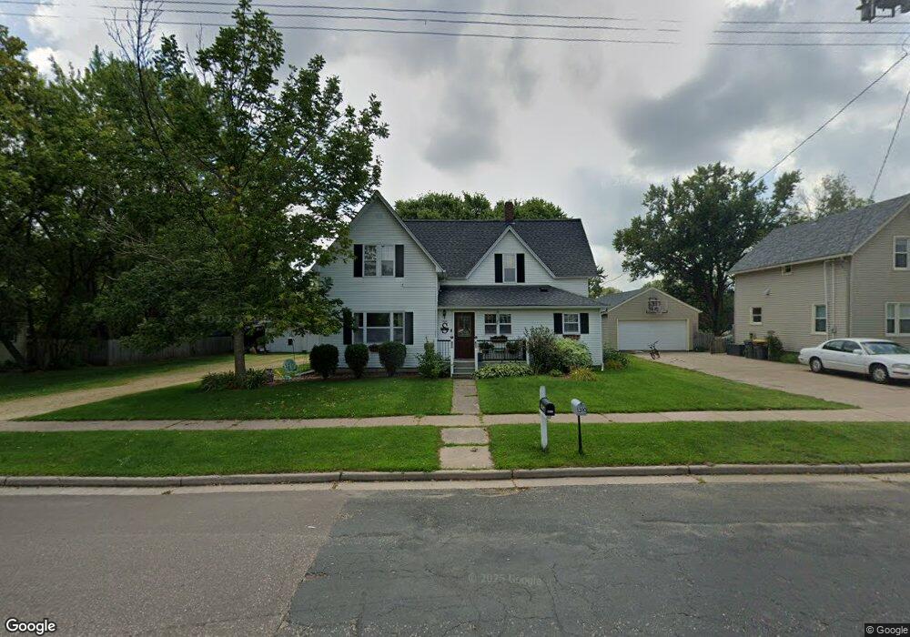
1300 Maple St Baldwin, WI 54002
Estimated Value: $244,000 - $304,000
3
Beds
1
Bath
--
Sq Ft
10,454
Sq Ft Lot
About This Home
This home is located at 1300 Maple St, Baldwin, WI 54002 and is currently estimated at $273,134. 1300 Maple St is a home located in St. Croix County with nearby schools including Greenfield Elementary School, Viking Middle School, and Baldwin-Woodville High School.
Ownership History
Date
Name
Owned For
Owner Type
Purchase Details
Closed on
Sep 4, 2015
Sold by
Tackmann John A and Tackmann Aubrey L
Bought by
Plante Cassandra J and Swan Andrew H
Current Estimated Value
Home Financials for this Owner
Home Financials are based on the most recent Mortgage that was taken out on this home.
Original Mortgage
$150,253
Outstanding Balance
$116,627
Interest Rate
3.97%
Mortgage Type
New Conventional
Estimated Equity
$156,507
Purchase Details
Closed on
Sep 16, 2009
Sold by
Langer Julie A and Langer Stephen J
Bought by
Tackmann John A
Home Financials for this Owner
Home Financials are based on the most recent Mortgage that was taken out on this home.
Original Mortgage
$117,346
Interest Rate
5.32%
Mortgage Type
New Conventional
Purchase Details
Closed on
Apr 9, 2007
Sold by
Hopkins Julie A and Langer Julie A
Bought by
Langer Julie A
Create a Home Valuation Report for This Property
The Home Valuation Report is an in-depth analysis detailing your home's value as well as a comparison with similar homes in the area
Home Values in the Area
Average Home Value in this Area
Purchase History
| Date | Buyer | Sale Price | Title Company |
|---|---|---|---|
| Plante Cassandra J | $154,900 | St Croix County Abstract & T | |
| Tackmann John A | $115,000 | None Available | |
| Langer Julie A | -- | None Available |
Source: Public Records
Mortgage History
| Date | Status | Borrower | Loan Amount |
|---|---|---|---|
| Open | Plante Cassandra J | $150,253 | |
| Previous Owner | Tackmann John A | $117,346 |
Source: Public Records
Tax History
| Year | Tax Paid | Tax Assessment Tax Assessment Total Assessment is a certain percentage of the fair market value that is determined by local assessors to be the total taxable value of land and additions on the property. | Land | Improvement |
|---|---|---|---|---|
| 2025 | $4,168 | $214,600 | $37,400 | $177,200 |
| 2024 | $40 | $214,600 | $37,400 | $177,200 |
| 2023 | $3,322 | $214,600 | $37,400 | $177,200 |
| 2022 | $3,265 | $214,600 | $37,400 | $177,200 |
| 2021 | $3,292 | $214,600 | $37,400 | $177,200 |
| 2020 | $3,178 | $150,500 | $28,000 | $122,500 |
| 2019 | $3,111 | $150,500 | $28,000 | $122,500 |
| 2018 | $2,872 | $150,500 | $28,000 | $122,500 |
| 2017 | $3,012 | $150,500 | $28,000 | $122,500 |
| 2016 | $3,012 | $150,500 | $28,000 | $122,500 |
| 2015 | $2,133 | $93,000 | $22,300 | $70,700 |
| 2014 | $1,922 | $93,000 | $22,300 | $70,700 |
| 2013 | $1,959 | $93,000 | $22,300 | $70,700 |
Source: Public Records
Map
Nearby Homes
- 1210 14th Ave
- 1130 Florence St
- 1239 Newton St
- 1230 Curtis St
- 1090 7th Ave
- 720 Newton St
- 1331 Franklin St
- xxx Lot #3 38th St
- 183 Pintail St
- 1621 Mallard Ave
- 1632 Mallard Ave
- 1629 Mallard Ave
- 1617 Mallard Ave
- 180 Pintail St
- 195 Pintail St
- 191 Pintail St
- 187 Pintail St
- 198 Pintail St
- 320 Bluebill St
- Lot 15 Summit Cir
Your Personal Tour Guide
Ask me questions while you tour the home.