Estimated Value: $280,274 - $302,000
--
Bed
3
Baths
2,068
Sq Ft
$141/Sq Ft
Est. Value
About This Home
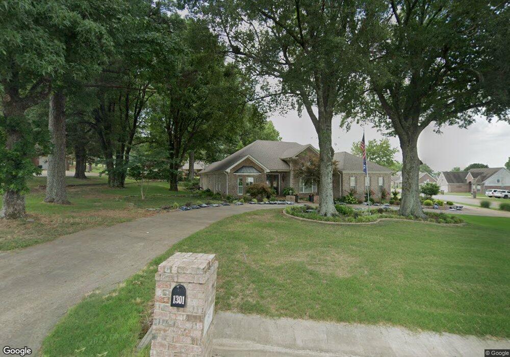
This home is located at 1301 Martin Dr E, Wynne, AR 72396 and is currently estimated at $291,569, approximately $140 per square foot. 1301 Martin Dr E is a home located in Cross County with nearby schools including Wynne Intermediate School, Wynne Primary School, and Wynne Junior High School.
Ownership History
Date
Name
Owned For
Owner Type
Purchase Details
Closed on
Jan 26, 2006
Sold by
Cook Manuela and Cook Joey
Bought by
Patterson Terrie Ann West
Current Estimated Value
Purchase Details
Closed on
Sep 21, 2004
Sold by
Hkr Llc
Bought by
Rowe James M and Rowe Barbara C
Purchase Details
Closed on
Jun 18, 2004
Bought by
Hkr, Llc.
Purchase Details
Closed on
Jul 18, 2003
Bought by
Cross County Bank
Purchase Details
Closed on
Sep 20, 1999
Bought by
Brawner Family Holdings
Purchase Details
Closed on
Aug 26, 1999
Bought by
Brawner Harrell E and Family Trust
Create a Home Valuation Report for This Property
The Home Valuation Report is an in-depth analysis detailing your home's value as well as a comparison with similar homes in the area
Home Values in the Area
Average Home Value in this Area
Purchase History
| Date | Buyer | Sale Price | Title Company |
|---|---|---|---|
| Patterson Terrie Ann West | $160,000 | None Available | |
| Rowe James M | -- | None Available | |
| Hkr, Llc. | $55,000 | -- | |
| Cross County Bank | -- | -- | |
| Brawner Family Holdings | -- | -- | |
| Brawner Harrell E | -- | -- |
Source: Public Records
Tax History Compared to Growth
Tax History
| Year | Tax Paid | Tax Assessment Tax Assessment Total Assessment is a certain percentage of the fair market value that is determined by local assessors to be the total taxable value of land and additions on the property. | Land | Improvement |
|---|---|---|---|---|
| 2024 | $1,357 | $40,530 | $5,280 | $35,250 |
| 2023 | $1,436 | $40,530 | $5,280 | $35,250 |
| 2022 | $1,486 | $40,530 | $5,280 | $35,250 |
| 2021 | $1,486 | $40,530 | $5,280 | $35,250 |
| 2020 | $1,486 | $40,530 | $5,280 | $35,250 |
| 2019 | $1,486 | $37,590 | $4,260 | $33,330 |
| 2018 | $1,511 | $37,590 | $4,260 | $33,330 |
| 2017 | $1,511 | $37,590 | $4,260 | $33,330 |
| 2016 | $1,511 | $37,590 | $4,260 | $33,330 |
| 2015 | $1,511 | $37,590 | $4,260 | $33,330 |
| 2014 | $1,511 | $39,610 | $5,000 | $34,610 |
Source: Public Records
Map
Nearby Homes
- 105 Chickasaw
- 104 Shawnee
- 1321 Martin Dr E
- 129 Lombardy Ln
- 733 Martin Dr E
- 701 Wren St
- 102 Lombardy Ln
- 206 Maple Dr
- 704 Mockingbird Ln
- 712 Mockingbird Ln
- 116 Bailey St S
- 0 0 Unit 24023180
- 903 Levesque Ave E
- 23 Southridge Cir
- 1484 Hamilton Ave E
- 43 Southridge Cir
- 2 Donegal Cir
- 6 A Londonderry Cir
- 919 Hamilton Ave E
- 568 Killough Rd N