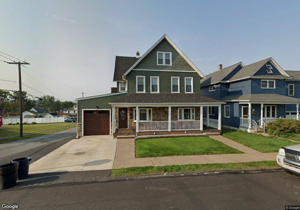
1301 Watson St Scranton, PA 18504
Hyde Park NeighborhoodEstimated Value: $209,000 - $300,000
--
Bed
--
Bath
--
Sq Ft
6,490
Sq Ft Lot
About This Home
This home is located at 1301 Watson St, Scranton, PA 18504 and is currently estimated at $250,362. 1301 Watson St is a home located in Lackawanna County with nearby schools including Longan Elementary School, Adams Elementary School, and Frances Willard School.
Ownership History
Date
Name
Owned For
Owner Type
Purchase Details
Closed on
Aug 30, 2019
Sold by
Coleman Thomas and Estate Of Kristine M Coleman
Bought by
Coleman Thomas
Current Estimated Value
Purchase Details
Closed on
Sep 26, 2008
Sold by
Gaughan James J
Bought by
Coleman Kristine M
Home Financials for this Owner
Home Financials are based on the most recent Mortgage that was taken out on this home.
Original Mortgage
$96,187
Outstanding Balance
$64,299
Interest Rate
6.54%
Mortgage Type
FHA
Estimated Equity
$186,063
Create a Home Valuation Report for This Property
The Home Valuation Report is an in-depth analysis detailing your home's value as well as a comparison with similar homes in the area
Home Values in the Area
Average Home Value in this Area
Purchase History
| Date | Buyer | Sale Price | Title Company |
|---|---|---|---|
| Coleman Thomas | -- | Reliable Abstract Co | |
| Coleman Kristine M | $120,000 | None Available |
Source: Public Records
Mortgage History
| Date | Status | Borrower | Loan Amount |
|---|---|---|---|
| Open | Coleman Kristine M | $96,187 |
Source: Public Records
Tax History Compared to Growth
Tax History
| Year | Tax Paid | Tax Assessment Tax Assessment Total Assessment is a certain percentage of the fair market value that is determined by local assessors to be the total taxable value of land and additions on the property. | Land | Improvement |
|---|---|---|---|---|
| 2025 | $2,047 | $6,000 | $1,550 | $4,450 |
| 2024 | $1,879 | $6,000 | $1,550 | $4,450 |
| 2023 | $1,879 | $6,000 | $1,550 | $4,450 |
| 2022 | $1,838 | $6,000 | $1,550 | $4,450 |
| 2021 | $1,838 | $6,000 | $1,550 | $4,450 |
| 2020 | $1,806 | $6,000 | $1,550 | $4,450 |
| 2019 | $1,701 | $6,000 | $1,550 | $4,450 |
| 2018 | $345 | $6,000 | $1,550 | $4,450 |
| 2017 | $1,673 | $6,000 | $1,550 | $4,450 |
| 2016 | $585 | $6,000 | $1,550 | $4,450 |
| 2015 | $948 | $6,000 | $1,550 | $4,450 |
| 2014 | -- | $6,000 | $1,550 | $4,450 |
Source: Public Records
Map
Nearby Homes
- 1301 Sloan St
- 1335 Sloan St
- 1227 Rundle St
- LOT#16 Reynolds Ave
- Lot# 7 Reynolds Ave
- 1411 Watson St
- 1115 Watson St
- 1143 Reynolds Ave
- 1234 Bryn Mawr St Unit 11
- 924 S Main Ave
- 816 12th Ave
- 1203 Acker Ave
- 1150 W Elm St
- 1250 S 1252 6th
- 610 Landis St
- 625 Landis St
- 1215 Eynon St
- 1223 Eynon St
- 1009 1011 Acker Ave Unit L 109
- 730 W Locust St
- 1303 Watson St
- 1307 Watson St
- 1261 Watson St
- 1309 Watson St
- 1300 Watson St Unit 1302
- 1300 Watson St Unit BLK
- 1311 Watson St
- 1259 Watson St
- 1302 Rundle St
- 1304 Rundle St
- 1260 Watson St
- 1315 Watson St
- 1310 Rundle St
- 1310 Rundle St
- 1105 1105 12 Rundle Unit 1/2
- 1120 Porter Ave
- 1257 Watson St
- 1308 Watson St
- 1256 Watson St Unit 1258
- 1308 Rundle St