Estimated Value: $181,000 - $205,000
3
Beds
2
Baths
1,459
Sq Ft
$133/Sq Ft
Est. Value
About This Home
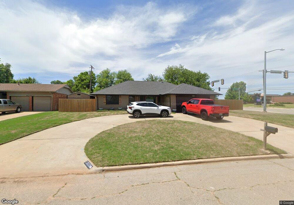
This home is located at 1302 Allen St, Yukon, OK 73099 and is currently estimated at $194,084, approximately $133 per square foot. 1302 Allen St is a home located in Canadian County with nearby schools including Myers Elementary School, Independence Elementary School, and Yukon Middle School.
Ownership History
Date
Name
Owned For
Owner Type
Purchase Details
Closed on
Mar 16, 2020
Sold by
Calkins Jeannice A
Bought by
Campbell Paul Andrews and Campbell Kari Anne
Current Estimated Value
Home Financials for this Owner
Home Financials are based on the most recent Mortgage that was taken out on this home.
Original Mortgage
$108,000
Outstanding Balance
$95,649
Interest Rate
3.5%
Mortgage Type
VA
Estimated Equity
$98,435
Purchase Details
Closed on
Oct 27, 2000
Sold by
Carrera Reagan and Carrera Kevin
Bought by
Calkins John and Calkins Jeannice A
Purchase Details
Closed on
Jul 2, 1999
Sold by
First Assembly Of God Church
Create a Home Valuation Report for This Property
The Home Valuation Report is an in-depth analysis detailing your home's value as well as a comparison with similar homes in the area
Home Values in the Area
Average Home Value in this Area
Purchase History
| Date | Buyer | Sale Price | Title Company |
|---|---|---|---|
| Campbell Paul Andrews | $108,000 | Old Republic Title | |
| Calkins John | $77,000 | -- | |
| -- | $65,000 | -- |
Source: Public Records
Mortgage History
| Date | Status | Borrower | Loan Amount |
|---|---|---|---|
| Open | Campbell Paul Andrews | $108,000 |
Source: Public Records
Tax History Compared to Growth
Tax History
| Year | Tax Paid | Tax Assessment Tax Assessment Total Assessment is a certain percentage of the fair market value that is determined by local assessors to be the total taxable value of land and additions on the property. | Land | Improvement |
|---|---|---|---|---|
| 2024 | -- | $17,039 | $1,980 | $15,059 |
| 2023 | $0 | $16,542 | $1,980 | $14,562 |
| 2022 | $0 | $16,061 | $1,980 | $14,081 |
| 2021 | $0 | $15,593 | $1,980 | $13,613 |
| 2020 | $1,653 | $15,327 | $1,980 | $13,347 |
| 2019 | $1,579 | $14,597 | $1,980 | $12,617 |
| 2018 | $1,508 | $13,902 | $1,980 | $11,922 |
| 2017 | $1,437 | $13,240 | $1,980 | $11,260 |
| 2016 | $1,370 | $12,737 | $1,980 | $10,757 |
| 2015 | $1,339 | $12,013 | $1,980 | $10,033 |
| 2014 | $1,339 | $12,145 | $1,980 | $10,165 |
Source: Public Records
Map
Nearby Homes
- 117 Asbill Ave
- 114 Larry Ave
- 14512 Rochefort Ln
- 14524 Giverny Ln
- 14500 Giverny Ln
- 1805 Janeen St
- 0 Landon Ln
- 1005 S 3rd St
- 1308 Holly Ave
- 1421 Spring Creek Dr
- 11200 SW 32nd St
- 301 Fay Ave
- 501 Queensboro Place
- 1008 Queensboro Place
- 904 Glenwood Dr
- 11501 NW 97th St
- 201 Vine St
- 1521 Spring Creek Dr
- 332 W Platt Dr
- 508 Kingston Dr
- 1306 Allen St
- 1310 Allen St
- 202 W Vandament Ave
- 1305 Allen St
- 1301 Allen St
- 1309 Allen St
- 1314 Allen St
- 1213 S 1st St
- 1313 Allen St
- 1211 S 1st St
- 1318 Allen St
- 206 W Vandament Ave
- 109 W Vandament Ave
- 1317 Allen St
- 1402 Allen St
- 210 W Vandament Ave
- 1209 S 1st St
- 1401 Allen St
- 118 Belisle Ave
- 1317 Glenda Dr