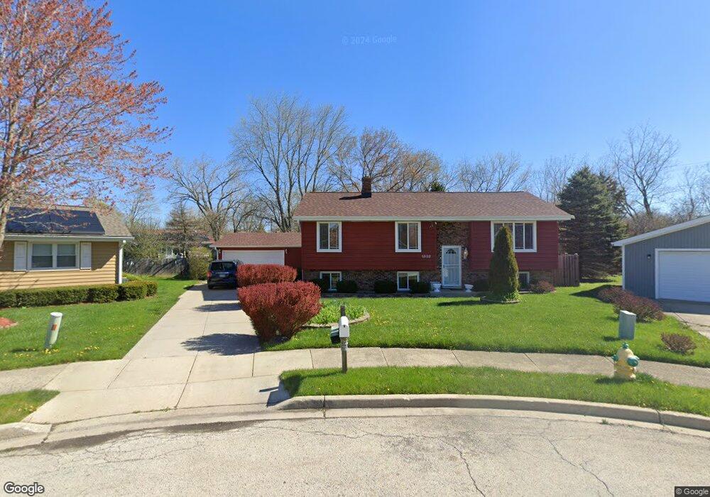
1302 Lizabeth Ln Waukegan, IL 60087
Lake County Gardens NeighborhoodEstimated Value: $272,000 - $310,038
3
Beds
2
Baths
1,118
Sq Ft
$253/Sq Ft
Est. Value
About This Home
This home is located at 1302 Lizabeth Ln, Waukegan, IL 60087 and is currently estimated at $282,760, approximately $252 per square foot. 1302 Lizabeth Ln is a home located in Lake County with nearby schools including H R McCall Elementary School, Jack Benny Middle School, and Waukegan High School.
Ownership History
Date
Name
Owned For
Owner Type
Purchase Details
Closed on
Oct 28, 1998
Sold by
Gardner Henry L and Gardner Shirlener
Bought by
Johnson Gloria J
Current Estimated Value
Home Financials for this Owner
Home Financials are based on the most recent Mortgage that was taken out on this home.
Original Mortgage
$102,000
Outstanding Balance
$30,033
Interest Rate
10.49%
Estimated Equity
$252,727
Create a Home Valuation Report for This Property
The Home Valuation Report is an in-depth analysis detailing your home's value as well as a comparison with similar homes in the area
Home Values in the Area
Average Home Value in this Area
Purchase History
| Date | Buyer | Sale Price | Title Company |
|---|---|---|---|
| Johnson Gloria J | $120,000 | -- |
Source: Public Records
Mortgage History
| Date | Status | Borrower | Loan Amount |
|---|---|---|---|
| Open | Johnson Gloria J | $102,000 | |
| Closed | Johnson Gloria J | $12,000 |
Source: Public Records
Tax History Compared to Growth
Tax History
| Year | Tax Paid | Tax Assessment Tax Assessment Total Assessment is a certain percentage of the fair market value that is determined by local assessors to be the total taxable value of land and additions on the property. | Land | Improvement |
|---|---|---|---|---|
| 2024 | $6,316 | $82,308 | $16,294 | $66,014 |
| 2023 | $6,047 | $74,979 | $14,838 | $60,141 |
| 2022 | $6,047 | $67,857 | $15,055 | $52,802 |
| 2021 | $5,706 | $60,731 | $13,398 | $47,333 |
| 2020 | $5,733 | $56,578 | $12,482 | $44,096 |
| 2019 | $5,721 | $51,845 | $11,438 | $40,407 |
| 2018 | $5,857 | $51,661 | $13,013 | $38,648 |
| 2017 | $5,651 | $45,706 | $11,513 | $34,193 |
| 2016 | $5,213 | $39,716 | $10,004 | $29,712 |
| 2015 | $4,991 | $35,547 | $8,954 | $26,593 |
| 2014 | $4,156 | $30,102 | $5,623 | $24,479 |
| 2012 | $5,370 | $32,612 | $6,091 | $26,521 |
Source: Public Records
Map
Nearby Homes
- 1636 Rice St
- 37905 N Loyola Ave
- 1612 Whitney St
- 37966 N Cornell Rd
- 38127 N Shore Ave
- 38362 N Manor Ave
- 3411 N Lewis Ave
- 3211 Rugby Ct
- 2613 N Lewis Ave
- 10241 W Bairstow Ave
- 301 W Eagle Ct
- 2350 N Lewis Ave
- 0 Traditions Dr
- 2232 Walnut St
- 1730 W Beach Rd
- 3101 Country Club Ln
- 38697 N Cedar Ave
- 37789 N Sheridan Rd
- 37231 N Ganster Rd
- 38101 N Sheridan Rd
- 1301 Lizabeth Ln
- 1304 Lizabeth Ln
- 1303 Macarthur Dr
- 1301 Macarthur Dr
- 1305 Macarthur Dr
- 1306 Lizabeth Ln
- 1303 Lizabeth Ln
- 1307 Macarthur Dr
- 1305 Lizabeth Ln
- 1308 Lizabeth Ln
- 1307 Lizabeth Ln
- 1309 Macarthur Dr
- 1309 Lizabeth Ln
- 1310 Lizabeth Ln
- 1311 Macarthur Dr
- 1304 Macarthur Dr
- 1311 Lizabeth Ln
- 1312 Lizabeth Ln