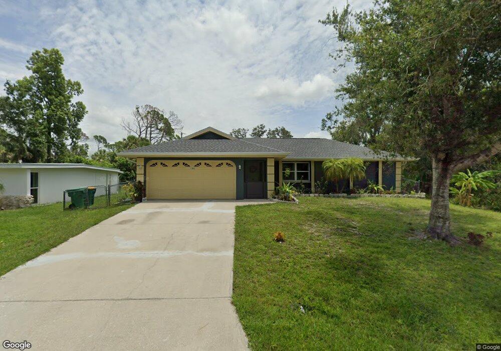
1302 Preston St Port Charlotte, FL 33952
Estimated Value: $232,231 - $271,000
3
Beds
2
Baths
1,194
Sq Ft
$204/Sq Ft
Est. Value
About This Home
This home is located at 1302 Preston St, Port Charlotte, FL 33952 and is currently estimated at $243,808, approximately $204 per square foot. 1302 Preston St is a home located in Charlotte County with nearby schools including Neil Armstrong Elementary School, Murdock Middle School, and Port Charlotte High School.
Ownership History
Date
Name
Owned For
Owner Type
Purchase Details
Closed on
Nov 15, 2013
Sold by
Barrett Roslin
Bought by
Mccalla Dave
Current Estimated Value
Purchase Details
Closed on
Jun 2, 2010
Sold by
Barrett Stanley Kerton
Bought by
Lindsay Barrett Roslin
Purchase Details
Closed on
Feb 3, 2005
Sold by
Melton Miriam L
Bought by
Lindsay Roslin
Home Financials for this Owner
Home Financials are based on the most recent Mortgage that was taken out on this home.
Original Mortgage
$70,000
Interest Rate
5.69%
Mortgage Type
Purchase Money Mortgage
Create a Home Valuation Report for This Property
The Home Valuation Report is an in-depth analysis detailing your home's value as well as a comparison with similar homes in the area
Home Values in the Area
Average Home Value in this Area
Purchase History
| Date | Buyer | Sale Price | Title Company |
|---|---|---|---|
| Mccalla Dave | $108,000 | None Available | |
| Lindsay Barrett Roslin | -- | None Available | |
| Lindsay Roslin | $80,000 | -- |
Source: Public Records
Mortgage History
| Date | Status | Borrower | Loan Amount |
|---|---|---|---|
| Previous Owner | Lindsay Roslin | $70,000 |
Source: Public Records
Tax History Compared to Growth
Tax History
| Year | Tax Paid | Tax Assessment Tax Assessment Total Assessment is a certain percentage of the fair market value that is determined by local assessors to be the total taxable value of land and additions on the property. | Land | Improvement |
|---|---|---|---|---|
| 2023 | $2,045 | $142,806 | $0 | $0 |
| 2022 | $1,949 | $138,647 | $0 | $0 |
| 2021 | $1,930 | $134,609 | $0 | $0 |
| 2020 | $1,879 | $132,750 | $4,505 | $128,245 |
| 2019 | $2,601 | $127,813 | $4,675 | $123,138 |
| 2018 | $2,317 | $122,607 | $4,250 | $118,357 |
| 2017 | $2,160 | $108,819 | $4,216 | $104,603 |
| 2016 | $2,041 | $85,707 | $0 | $0 |
| 2015 | $1,869 | $77,915 | $0 | $0 |
| 2014 | $1,745 | $70,832 | $0 | $0 |
Source: Public Records
Map
Nearby Homes
- 1366 Preston St
- 1302 Arrow St
- 20284 Emerald Ave
- 20330 Emerald Ave
- 1317 Arrow St
- 1358 Fargo St
- 1381 Fargo St
- 1357 Nimrod St
- 20430 Sapling Ave
- 20297 Kinderkemac Ave
- 20296 Rutherford Ave
- 1181 Oxsalida St
- 20190 Rutherford Ave
- 20307 Zelda Ave
- 20431 Stardust Ave
- 1196 Hinton St
- 1170 Peppertree Ln
- 20260 Tralee Dr
- 1469 Proper St
- 20246 Rutherford Ave
- 1294 Street
- 1294 Preston St
- 1301 Eagle St
- 1309 Eagle St
- 1318 Preston St
- 1310 Preston St Unit 2696507-2805
- 1326 Preston St
- 1293 Preston St
- 1301 Preston St
- 1317 Eagle St
- 1309 Preston St
- 20378 Emerald Ave
- 20370 Emerald Ave
- 20386 Emerald Ave
- 20362 Emerald Ave
- 1325 Eagle St
- 1325 Preston St
- 1302 Eagle St
- 1294 Arrow St