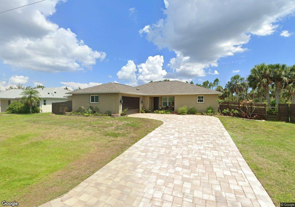
13025 Batlin Ave Port Charlotte, FL 33953
Northwest Port Charlotte NeighborhoodEstimated Value: $502,187 - $665,000
3
Beds
2
Baths
2,110
Sq Ft
$272/Sq Ft
Est. Value
About This Home
This home is located at 13025 Batlin Ave, Port Charlotte, FL 33953 and is currently estimated at $573,547, approximately $271 per square foot. 13025 Batlin Ave is a home with nearby schools including Liberty Elementary School, Murdock Middle School, and Port Charlotte High School.
Ownership History
Date
Name
Owned For
Owner Type
Purchase Details
Closed on
Feb 13, 2023
Sold by
Salk Chad Matthew
Bought by
Salk Chad Matthew and Salk Mary Jo
Current Estimated Value
Purchase Details
Closed on
Apr 10, 2018
Sold by
Salk Chad Matthew
Bought by
Salk Chad Matthew and Rayfield Mary Jo
Purchase Details
Closed on
May 21, 2010
Sold by
Salk Clayton A and Salk Joanne E
Bought by
Salk Chad
Purchase Details
Closed on
Nov 14, 2005
Sold by
Patrick Carl
Bought by
Salk Clayton A and Salk Joanne E
Create a Home Valuation Report for This Property
The Home Valuation Report is an in-depth analysis detailing your home's value as well as a comparison with similar homes in the area
Home Values in the Area
Average Home Value in this Area
Purchase History
| Date | Buyer | Sale Price | Title Company |
|---|---|---|---|
| Salk Chad Matthew | -- | -- | |
| Salk Chad Matthew | -- | Attorney | |
| Salk Chad Matthew | -- | Attorney | |
| Salk Chad | -- | None Available | |
| Salk Clayton A | $74,000 | Aaction Title Agency Inc |
Source: Public Records
Tax History Compared to Growth
Tax History
| Year | Tax Paid | Tax Assessment Tax Assessment Total Assessment is a certain percentage of the fair market value that is determined by local assessors to be the total taxable value of land and additions on the property. | Land | Improvement |
|---|---|---|---|---|
| 2024 | $3,287 | $149,227 | -- | -- |
| 2023 | $3,287 | $133,211 | $0 | $0 |
| 2022 | $3,155 | $129,331 | $0 | $0 |
| 2021 | $3,141 | $125,564 | $0 | $0 |
| 2020 | $3,065 | $123,830 | $0 | $0 |
| 2019 | $2,966 | $121,046 | $0 | $0 |
| 2018 | $2,795 | $118,789 | $0 | $0 |
| 2017 | $2,765 | $116,346 | $0 | $0 |
| 2016 | $2,742 | $113,953 | $0 | $0 |
| 2015 | $2,731 | $113,161 | $0 | $0 |
| 2014 | $2,307 | $112,263 | $0 | $0 |
Source: Public Records
Map
Nearby Homes
- 13057 Batlin Ave
- 13048 Devereaux Ave
- 1267 Patton St
- 13006 Devereaux Ave
- 1264 Forrestal St
- 1130 Forrestal St
- 1160 Shell St
- 1150 or 1160 Delmore St
- 1307 Quantico St
- 1315 Quantico St
- 1267 Quantico St
- 1300 Quantico St
- 1039 Gibbon St
- 1315 Ramsey St
- 13046 Chiminiello Dr
- 1307 Sanford St
- 1232 Sanford St
- 13101 Chiminiello Dr
- 13070 Chiminiello Dr
- 1045 Rhinelander St
- 13033 Batlin Ave
- 13041 Batlin Ave
- 13024 Devereaux Ave
- 13032 Devereaux Ave
- 13040 Devereaux Ave
- 1292 Patton St
- 1284 Patton St
- 1284 - 1292 Patton St
- 1275 Patton St
- 1308 Patton St Unit 9
- 1276 Patton St
- 1355 Patton St
- 1308 Patton St
- 1240 Patton St
- 1251 Patton St
- 13056 Devereaux Ave
- 13065 Batlin Ave
- 1240 Stewart St
- 13005, 13006 & 13025 Devereaux Ave
- 13064 Devereaux Ave