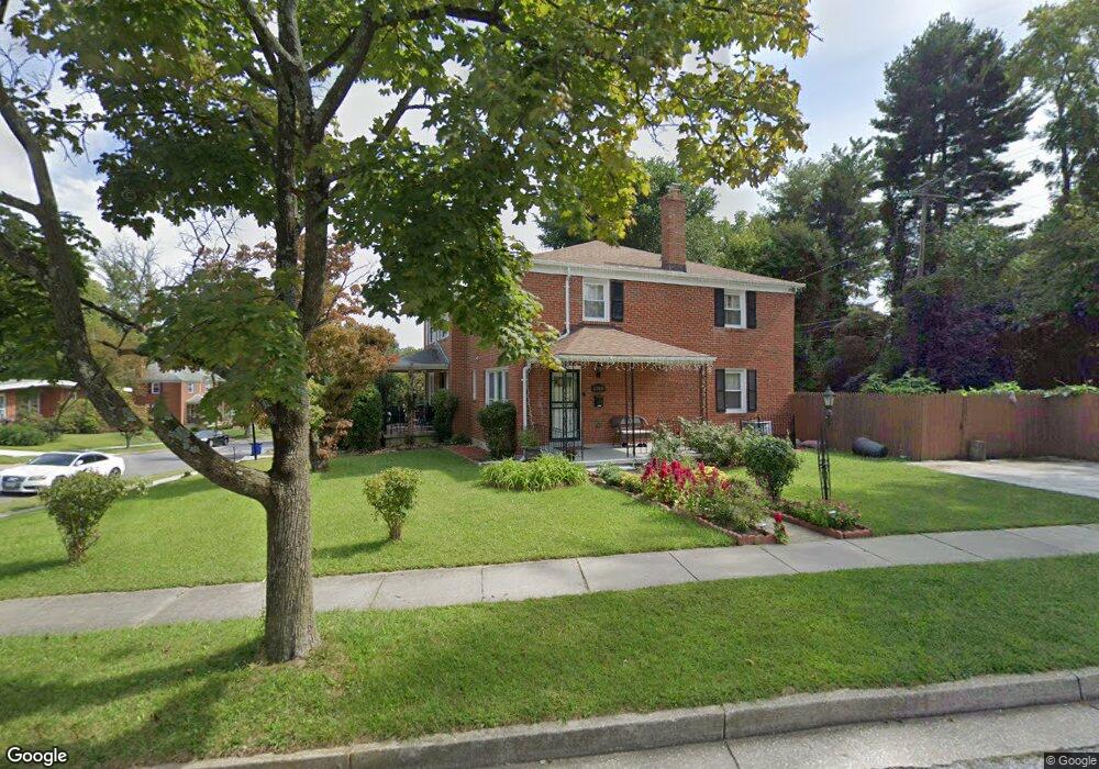
1303 Brixton Rd Baltimore, MD 21239
Estimated Value: $288,000 - $330,000
--
Bed
3
Baths
1,496
Sq Ft
$206/Sq Ft
Est. Value
About This Home
This home is located at 1303 Brixton Rd, Baltimore, MD 21239 and is currently estimated at $308,431, approximately $206 per square foot. 1303 Brixton Rd is a home located in Baltimore County with nearby schools including Halstead Academy, Loch Raven Technical Academy, and Towson High Law & Public Policy.
Ownership History
Date
Name
Owned For
Owner Type
Purchase Details
Closed on
Jul 26, 1994
Sold by
Ewell Dawn E
Bought by
Harvey Joyce
Current Estimated Value
Home Financials for this Owner
Home Financials are based on the most recent Mortgage that was taken out on this home.
Original Mortgage
$101,074
Interest Rate
8.19%
Purchase Details
Closed on
May 19, 1970
Sold by
Tattersall James F
Bought by
Ewell Dawn E
Create a Home Valuation Report for This Property
The Home Valuation Report is an in-depth analysis detailing your home's value as well as a comparison with similar homes in the area
Home Values in the Area
Average Home Value in this Area
Purchase History
| Date | Buyer | Sale Price | Title Company |
|---|---|---|---|
| Harvey Joyce | $99,900 | -- | |
| Ewell Dawn E | $17,500 | -- |
Source: Public Records
Mortgage History
| Date | Status | Borrower | Loan Amount |
|---|---|---|---|
| Closed | Harvey Joyce | $101,074 |
Source: Public Records
Tax History Compared to Growth
Tax History
| Year | Tax Paid | Tax Assessment Tax Assessment Total Assessment is a certain percentage of the fair market value that is determined by local assessors to be the total taxable value of land and additions on the property. | Land | Improvement |
|---|---|---|---|---|
| 2025 | $3,463 | $231,600 | $80,000 | $151,600 |
| 2024 | $3,463 | $221,133 | $0 | $0 |
| 2023 | $3,288 | $210,667 | $0 | $0 |
| 2022 | $3,136 | $200,200 | $80,000 | $120,200 |
| 2021 | $3,040 | $194,400 | $0 | $0 |
| 2020 | $3,040 | $188,600 | $0 | $0 |
| 2019 | $2,995 | $182,800 | $80,000 | $102,800 |
| 2018 | $2,868 | $179,667 | $0 | $0 |
| 2017 | $2,648 | $176,533 | $0 | $0 |
| 2016 | $2,722 | $173,400 | $0 | $0 |
| 2015 | $2,722 | $173,400 | $0 | $0 |
| 2014 | $2,722 | $173,400 | $0 | $0 |
Source: Public Records
Map
Nearby Homes
- 1204 Saint Andrews Way
- 6702 Queens Ferry Rd
- 1108 Litchfield Rd
- 6931 Summit Cir
- 6923 Summit Cir
- 908 Stevenson Ln
- 12 Stone Ridge Ct
- 28 Stone Ridge Ct
- 701 Hillen Rd
- 703 Hillen Rd
- 6415 Falkirk Rd
- 1211 Dalton Rd
- 6216 Falkirk Rd
- 625 Yarmouth Rd
- 1235 Walker Ave
- 6204 Falkirk Rd
- 1283 Gittings Ave
- 1304 Dartmouth Ave
- 664 Regester Ave
- 1602 Glen Keith Blvd
- 1301 Brixton Rd
- 1307 Brixton Rd
- 1309 Brixton Rd
- 1300 Highland Dr
- 1302 Highland Dr
- 1217 Brixton Rd
- 1302 Brixton Rd
- 1311 Brixton Rd
- 1304 Highland Dr
- 1304 Brixton Rd
- 1300 Brixton Rd
- 1215 Brixton Rd
- 1306 Brixton Rd
- 1234 Saint Andrews Way
- 1313 Brixton Rd
- 1308 Brixton Rd
- 1306 Highland Dr
- 1213 Brixton Rd
- 1216 Brixton Rd
- 1310 Brixton Rd