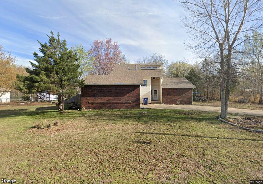
1303 Yukon Dr Webb City, MO 64870
Estimated Value: $169,000 - $213,798
3
Beds
2
Baths
1,577
Sq Ft
$123/Sq Ft
Est. Value
About This Home
This home is located at 1303 Yukon Dr, Webb City, MO 64870 and is currently estimated at $193,700, approximately $122 per square foot. 1303 Yukon Dr is a home located in Jasper County with nearby schools including Webb City High School and Thomas Jefferson Independent Day School.
Ownership History
Date
Name
Owned For
Owner Type
Purchase Details
Closed on
Oct 17, 2024
Sold by
Hickman Sandra M and Hettinger Norman D
Bought by
Eaton Clinton and Eaton Suzanna
Current Estimated Value
Home Financials for this Owner
Home Financials are based on the most recent Mortgage that was taken out on this home.
Original Mortgage
$147,000
Outstanding Balance
$145,261
Interest Rate
6.2%
Mortgage Type
New Conventional
Estimated Equity
$48,439
Create a Home Valuation Report for This Property
The Home Valuation Report is an in-depth analysis detailing your home's value as well as a comparison with similar homes in the area
Home Values in the Area
Average Home Value in this Area
Purchase History
| Date | Buyer | Sale Price | Title Company |
|---|---|---|---|
| Eaton Clinton | -- | None Listed On Document |
Source: Public Records
Mortgage History
| Date | Status | Borrower | Loan Amount |
|---|---|---|---|
| Open | Eaton Clinton | $147,000 |
Source: Public Records
Tax History Compared to Growth
Tax History
| Year | Tax Paid | Tax Assessment Tax Assessment Total Assessment is a certain percentage of the fair market value that is determined by local assessors to be the total taxable value of land and additions on the property. | Land | Improvement |
|---|---|---|---|---|
| 2025 | $1,065 | $25,000 | $6,780 | $18,220 |
| 2024 | $1,066 | $22,920 | $6,780 | $16,140 |
| 2023 | $1,066 | $22,920 | $6,780 | $16,140 |
| 2022 | $1,124 | $24,250 | $6,780 | $17,470 |
| 2021 | $1,112 | $24,250 | $6,780 | $17,470 |
| 2020 | $1,062 | $22,730 | $6,780 | $15,950 |
| 2019 | $1,065 | $22,730 | $6,780 | $15,950 |
| 2018 | $1,038 | $22,230 | $0 | $0 |
| 2017 | $1,041 | $22,230 | $0 | $0 |
| 2016 | $1,059 | $22,690 | $0 | $0 |
| 2015 | -- | $22,690 | $0 | $0 |
| 2014 | -- | $22,690 | $0 | $0 |
Source: Public Records
Map
Nearby Homes
- 1411 Gold Stream Dr
- 727 E Wickersham Dr
- 1502 S College St
- 717 & 719 S Madison St
- 1207 W 7th St
- 1749 W 12th St
- 719 S Madison St
- 717 S Madison St
- 801 W 12th St
- 1104 Lakeview Dr
- 1615 Anderson Dr
- 1740 Betenbough Way
- 1747 Kent Dr
- XXXX Meadowmere Dr
- 2575 Plan at Boyer Farm
- 1818 W Fountain Rd
- 1759 Kent Dr
- 1710 Mando Ln
- 1706 Mando Ln
- 1818 Fountain Rd
- 1311 Yukon Dr
- 1227 W 9th St
- 1225 W 9th St
- 1229 W 9th St
- 1204 Gold Pan Dr
- 1204 Gold Pan Dr Unit 1
- 1223 W 9th St
- 1231 W 9th St
- 1221 W 9th St
- 753 W Wickersham Dr
- 1208 Gold Pan Dr
- 1202 Gold Dust Dr
- 1207 Gold Dust Dr
- 1226 W 9th St
- 751 W Wickersham Dr
- 806 E Wickersham Dr
- 758 W Wickersham Dr
- 1224 W 9th St
- 809 E Wickersham Dr
- 1206 Gold Dust Dr