Estimated Value: $284,000 - $410,000
4
Beds
2
Baths
2,292
Sq Ft
$153/Sq Ft
Est. Value
About This Home
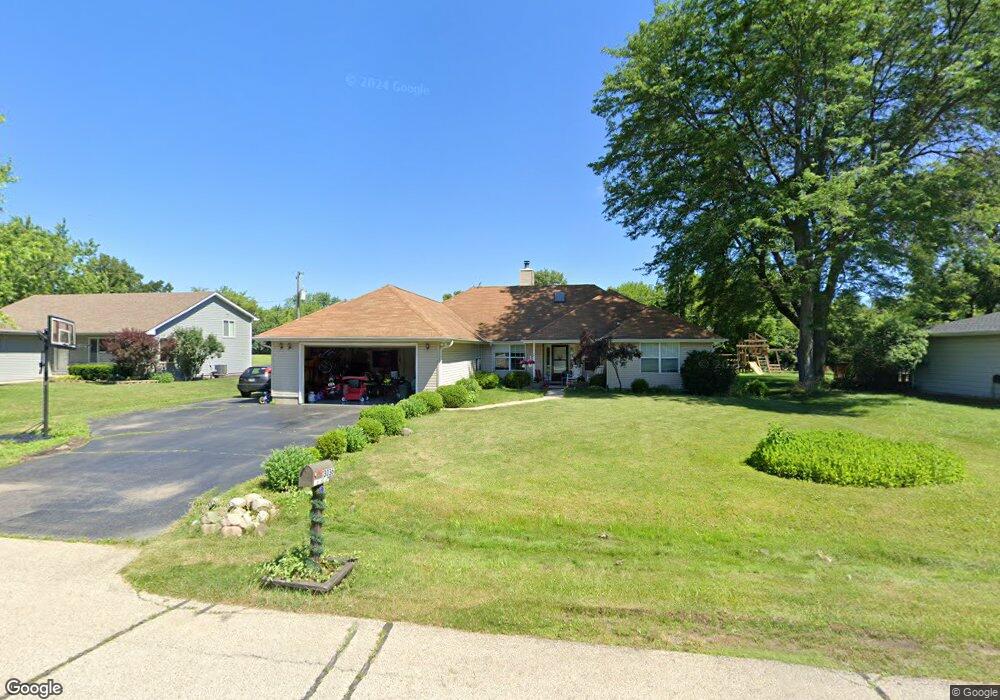
This home is located at 13036 W 27th Place, Zion, IL 60099 and is currently estimated at $350,462, approximately $152 per square foot. 13036 W 27th Place is a home located in Lake County with nearby schools including Kenneth Murphy School, Beach Park Middle School, and Zion-Benton Township High School.
Ownership History
Date
Name
Owned For
Owner Type
Purchase Details
Closed on
Aug 18, 2009
Sold by
Us Bank National Association
Bought by
Kreuscher Shane and Kreuscher Stacy L
Current Estimated Value
Home Financials for this Owner
Home Financials are based on the most recent Mortgage that was taken out on this home.
Original Mortgage
$135,100
Interest Rate
5.07%
Mortgage Type
Seller Take Back
Purchase Details
Closed on
Dec 15, 2008
Sold by
Krial
Bought by
Us Bank National Association
Create a Home Valuation Report for This Property
The Home Valuation Report is an in-depth analysis detailing your home's value as well as a comparison with similar homes in the area
Home Values in the Area
Average Home Value in this Area
Purchase History
| Date | Buyer | Sale Price | Title Company |
|---|---|---|---|
| Kreuscher Shane | $140,000 | First American Title | |
| Us Bank National Association | -- | None Available |
Source: Public Records
Mortgage History
| Date | Status | Borrower | Loan Amount |
|---|---|---|---|
| Previous Owner | Kreuscher Shane | $135,100 |
Source: Public Records
Tax History Compared to Growth
Tax History
| Year | Tax Paid | Tax Assessment Tax Assessment Total Assessment is a certain percentage of the fair market value that is determined by local assessors to be the total taxable value of land and additions on the property. | Land | Improvement |
|---|---|---|---|---|
| 2024 | $7,975 | $101,998 | $18,576 | $83,422 |
| 2023 | $7,613 | $84,904 | $15,496 | $69,408 |
| 2022 | $7,613 | $78,371 | $13,819 | $64,552 |
| 2021 | $7,321 | $71,921 | $12,640 | $59,281 |
| 2020 | $7,309 | $70,249 | $12,346 | $57,903 |
| 2019 | $7,374 | $67,462 | $11,856 | $55,606 |
| 2018 | $7,033 | $62,049 | $10,634 | $51,415 |
| 2017 | $7,114 | $60,898 | $10,437 | $50,461 |
| 2016 | $7,074 | $58,861 | $10,088 | $48,773 |
| 2015 | $7,041 | $55,587 | $9,527 | $46,060 |
| 2014 | $4,718 | $42,683 | $9,266 | $33,417 |
| 2012 | $4,777 | $43,395 | $9,421 | $33,974 |
Source: Public Records
Map
Nearby Homes
- 13051 Bucksburn Ct
- 39787 Torry Ln
- 13661 W Adams Rd
- 13551 W Adams Rd
- 13129 W Shannon Dr
- 39631 N Warren Ln Unit 4625
- 13154 W Sheffield Ln
- 39616 N Warren Ln Unit 4824
- 42334 N Heritage Lot 7 Trail
- 2414 Phillip Dr
- 39520 N Green Bay Rd
- 13428 Victoria Ln
- 2407 Phillip Dr
- 2407 Miriam Ave
- 2031 Dawn Ln
- 2413 Michael Ave
- 39401 N Green Bay Rd
- 1916 Sunshine Ct
- 40661 N Delany Rd
- 14067 W Pratum Terra Dr
- 13033 W 27th Place
- 13064 W 27th Place
- 13026 W 27th Place
- 13098 W 27th Place
- 13033 W 27th Place
- 13025 W 27th Place
- 13122 W 27th Place
- 13099 W 27th Place
- 13099 W 27th Place
- 12968 W 27th Place
- 13080 W 28th St
- 13032 W 28th St
- 13060 W 28th St
- 12981 W 27th Place
- 13121 W 27th Place
- 13090 W 28th St
- 13121 W 27th Place
- 12976 W 28th St
- 12930 W 27th Place
- 13110 W 28th St