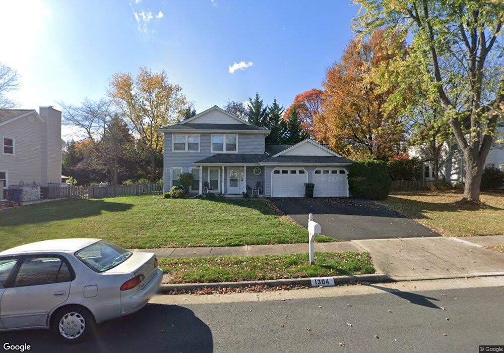
1304 Boulder Crest Ct Herndon, VA 20170
Estimated Value: $707,000 - $775,000
3
Beds
3
Baths
1,630
Sq Ft
$458/Sq Ft
Est. Value
About This Home
This home is located at 1304 Boulder Crest Ct, Herndon, VA 20170 and is currently estimated at $745,996, approximately $457 per square foot. 1304 Boulder Crest Ct is a home located in Fairfax County with nearby schools including Dranesville Elementary, Herndon Middle School, and Herndon High School.
Ownership History
Date
Name
Owned For
Owner Type
Purchase Details
Closed on
Feb 25, 2003
Sold by
Carlson Dana J
Bought by
Spiewak Robert E
Current Estimated Value
Home Financials for this Owner
Home Financials are based on the most recent Mortgage that was taken out on this home.
Original Mortgage
$220,000
Outstanding Balance
$95,268
Interest Rate
5.98%
Mortgage Type
New Conventional
Estimated Equity
$650,728
Create a Home Valuation Report for This Property
The Home Valuation Report is an in-depth analysis detailing your home's value as well as a comparison with similar homes in the area
Home Values in the Area
Average Home Value in this Area
Purchase History
| Date | Buyer | Sale Price | Title Company |
|---|---|---|---|
| Spiewak Robert E | $300,000 | -- |
Source: Public Records
Mortgage History
| Date | Status | Borrower | Loan Amount |
|---|---|---|---|
| Open | Spiewak Robert E | $220,000 |
Source: Public Records
Tax History Compared to Growth
Tax History
| Year | Tax Paid | Tax Assessment Tax Assessment Total Assessment is a certain percentage of the fair market value that is determined by local assessors to be the total taxable value of land and additions on the property. | Land | Improvement |
|---|---|---|---|---|
| 2025 | $6,614 | $617,210 | $244,000 | $373,210 |
| 2024 | $6,614 | $570,890 | $244,000 | $326,890 |
| 2023 | $6,151 | $545,030 | $239,000 | $306,030 |
| 2022 | $6,088 | $532,400 | $239,000 | $293,400 |
| 2021 | $5,496 | $468,320 | $204,000 | $264,320 |
| 2020 | $5,363 | $453,140 | $194,000 | $259,140 |
| 2019 | $5,184 | $438,060 | $189,000 | $249,060 |
| 2018 | $4,837 | $420,600 | $184,000 | $236,600 |
| 2017 | $4,838 | $416,710 | $184,000 | $232,710 |
| 2016 | $4,771 | $411,860 | $184,000 | $227,860 |
| 2015 | $4,495 | $402,740 | $184,000 | $218,740 |
| 2014 | $4,493 | $403,470 | $184,000 | $219,470 |
Source: Public Records
Map
Nearby Homes
- 1551 Brownsville Dr
- 1330 Rock Chapel Rd
- 1324 Rock Chapel Rd
- 12546 Rock Ridge Rd
- 1407 Skyhaven Ct
- 12406 Shallow Ford Ct
- 12592 Rock Ridge Rd
- 207 N Laura Anne Dr
- 1525 Hiddenbrook Dr
- 501 Tavenner Ct
- 12520 Ridgegate Dr
- 1314 E Holly Ave
- 46893 Eaton Terrace Unit 300
- 1205 Cameo Ct
- 21845 Baldwin Square Unit 101
- 1107 E Beech Rd
- 316 Hanford Ct
- 46932 Courtyard Square
- 11 Butternut Way
- 104 N Garfield Rd
- 1306 Boulder Crest Ct
- 1302 Boulder Crest Ct
- 1323 Mason Mill Ct
- 1305 Boulder Crest Ct
- 1307 Boulder Crest Ct
- 1308 Boulder Crest Ct
- 1300 Boulder Crest Ct
- 1321 Mason Mill Ct
- 1325 Mason Mill Ct
- 12528 Browns Ferry Rd
- 1319 Mason Mill Ct
- 1303 Boulder Crest Ct
- 1301 Boulder Crest Ct
- 1309 Boulder Crest Ct
- 12530 Browns Ferry Rd
- 1327 Mason Mill Ct
- 12400 Rock Ridge Rd
- 12402 Rock Ridge Rd
- 1429 Powells Tavern Place
- 12398 Rock Ridge Rd