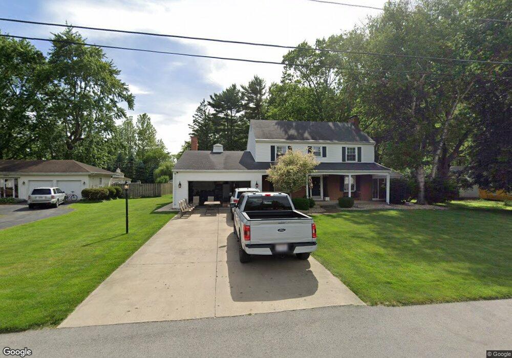
1304 Buchman Rd Fremont, OH 43420
Estimated Value: $260,894 - $297,000
4
Beds
3
Baths
2,376
Sq Ft
$116/Sq Ft
Est. Value
About This Home
This home is located at 1304 Buchman Rd, Fremont, OH 43420 and is currently estimated at $274,474, approximately $115 per square foot. 1304 Buchman Rd is a home located in Sandusky County with nearby schools including Fremont Ross High School, St. Joseph School, and Bishop Hoffman Catholic School - This is St Joe's School now.
Ownership History
Date
Name
Owned For
Owner Type
Purchase Details
Closed on
Aug 1, 2019
Sold by
Schwartz Thomas J and Schwartz Terri M
Bought by
Trautwein Hunter L and Trautwein Carly M
Current Estimated Value
Home Financials for this Owner
Home Financials are based on the most recent Mortgage that was taken out on this home.
Original Mortgage
$170,000
Interest Rate
3.73%
Mortgage Type
Stand Alone First
Purchase Details
Closed on
Apr 7, 2017
Sold by
Schwartz David W and John H Schwartz Living Trust
Bought by
Schwartz Thomas J and Schwartz Terri M
Create a Home Valuation Report for This Property
The Home Valuation Report is an in-depth analysis detailing your home's value as well as a comparison with similar homes in the area
Home Values in the Area
Average Home Value in this Area
Purchase History
| Date | Buyer | Sale Price | Title Company |
|---|---|---|---|
| Trautwein Hunter L | $193,000 | None Available | |
| Schwartz Thomas J | $183,000 | Attorney |
Source: Public Records
Mortgage History
| Date | Status | Borrower | Loan Amount |
|---|---|---|---|
| Previous Owner | Trautwein Hunter L | $170,000 |
Source: Public Records
Tax History Compared to Growth
Tax History
| Year | Tax Paid | Tax Assessment Tax Assessment Total Assessment is a certain percentage of the fair market value that is determined by local assessors to be the total taxable value of land and additions on the property. | Land | Improvement |
|---|---|---|---|---|
| 2024 | $2,797 | $71,960 | $9,730 | $62,230 |
| 2023 | $2,797 | $61,530 | $8,330 | $53,200 |
| 2022 | $2,554 | $61,530 | $8,330 | $53,200 |
| 2021 | $2,631 | $61,530 | $8,330 | $53,200 |
| 2020 | $2,571 | $58,940 | $8,330 | $50,610 |
| 2019 | $2,568 | $58,940 | $8,330 | $50,610 |
| 2018 | $2,499 | $58,940 | $8,330 | $50,610 |
| 2017 | $2,283 | $52,330 | $8,330 | $44,000 |
| 2016 | $1,628 | $52,330 | $8,330 | $44,000 |
| 2015 | $1,602 | $52,330 | $8,330 | $44,000 |
| 2014 | $1,656 | $51,910 | $8,230 | $43,680 |
| 2013 | $1,621 | $51,910 | $8,230 | $43,680 |
Source: Public Records
Map
Nearby Homes
- 2484 Buckland Ave
- 1719 Buckland Ave
- 1485 Autumn Woods Dr
- 1420 Center St
- 10 Meadowbrook Dr
- 10 Meadowbrook Ln
- 64 River Run Dr Unit J
- 1611 Mcpherson Blvd
- 1028 June St
- 1013 Whittlesey St
- 515 Everett Rd
- 135 Briarwood Cir
- 905 Twinn St
- 704 County Road 126
- 1015 Hayes Ave
- 1037 Buckland Ave
- 2119 Lake St
- 350 Conner Dr
- 1818 Finley Dr
- 815 South St
- 1232 Buchman Rd
- 1314 Buchman Rd
- 1320 Buchman Rd
- 1303 Buchman Rd
- 2462 Buckland Ave
- 2456 Buckland Ave
- 2450 Buckland Ave
- 2468 Buckland Ave
- 1225 Buchman Rd
- 1214 Buchman Rd
- 2474 Buckland Ave
- 2436 Buckland Ave
- 1215 Buchman Rd
- 1208 Buchman Rd
- 1344 Tucker Rd
- 1302 Tucker Rd
- 2459 Buckland Ave
- 2418 Buckland Ave
- 2504 Buckland Ave
- 2447 Buckland Ave