Estimated Value: $300,000 - $320,642
3
Beds
1
Bath
1,050
Sq Ft
$298/Sq Ft
Est. Value
About This Home
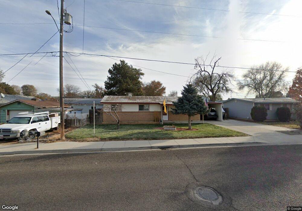
This home is located at 1304 Holly St, Nampa, ID 83686 and is currently estimated at $313,161, approximately $298 per square foot. 1304 Holly St is a home located in Canyon County with nearby schools including Kamali'i Elementary School, Waikele Elementary School, and Sherman Elementary School.
Ownership History
Date
Name
Owned For
Owner Type
Purchase Details
Closed on
Mar 27, 2019
Sold by
Mccasland Myron P
Bought by
Endicott Jon D
Current Estimated Value
Home Financials for this Owner
Home Financials are based on the most recent Mortgage that was taken out on this home.
Original Mortgage
$139,920
Outstanding Balance
$123,015
Interest Rate
4.3%
Mortgage Type
New Conventional
Estimated Equity
$190,146
Create a Home Valuation Report for This Property
The Home Valuation Report is an in-depth analysis detailing your home's value as well as a comparison with similar homes in the area
Home Values in the Area
Average Home Value in this Area
Purchase History
| Date | Buyer | Sale Price | Title Company |
|---|---|---|---|
| Endicott Jon D | -- | Pioneer Title Canyon |
Source: Public Records
Mortgage History
| Date | Status | Borrower | Loan Amount |
|---|---|---|---|
| Open | Endicott Jon D | $139,920 |
Source: Public Records
Tax History Compared to Growth
Tax History
| Year | Tax Paid | Tax Assessment Tax Assessment Total Assessment is a certain percentage of the fair market value that is determined by local assessors to be the total taxable value of land and additions on the property. | Land | Improvement |
|---|---|---|---|---|
| 2025 | $1,000 | $309,000 | $114,000 | $195,000 |
| 2024 | $1,000 | $286,500 | $101,300 | $185,200 |
| 2023 | $967 | $287,800 | $101,300 | $186,500 |
| 2022 | $2,141 | $290,100 | $114,000 | $176,100 |
| 2021 | $1,202 | $204,000 | $57,000 | $147,000 |
| 2020 | $1,116 | $172,400 | $47,500 | $124,900 |
| 2019 | $1,197 | $149,200 | $41,200 | $108,000 |
| 2018 | $1,160 | $0 | $0 | $0 |
| 2017 | $1,016 | $0 | $0 | $0 |
| 2016 | $926 | $0 | $0 | $0 |
| 2015 | $836 | $0 | $0 | $0 |
| 2014 | $738 | $75,700 | $17,500 | $58,200 |
Source: Public Records
Map
Nearby Homes
- 912 E Amity Ave
- 107 S Maple St
- 1017 S Maple St
- 1020 S Maple St
- 1426 E Sharons Loop
- 1157 S Powerline Rd
- 115 E Clark Ave
- 2121 Lambert Dr
- 1207 E Sheridan Ave
- 525 E Greenhurst Rd
- 307 S Locust St
- 612 S Pine St
- 223 S Elder St
- 2345 S Garland St
- 219 S Locust St
- 1801 E Iowa Ave
- 416 S Powerline Rd
- 1849 E Celbridge St
- 315 S Powerline Rd
- 1047 S 20th St
- 1304 S Holly St
- 1308 Holly St
- 1224 Holly St
- 1312 Holly St
- 1220 Holly St
- 1220 S Holly St
- 1303 Garland St
- 1223 Garland St
- 1316 Holly St
- 1216 Holly St
- 1311 Garland St
- 1221 Garland St
- 1307 Holly St
- 1223 Holly St
- 1307 & 130 S Holly St
- 1307 & 1309 S Holly St
- 1303 Holly St
- 1212 Holly St
- 1315 Garland St
- 1215 Garland St