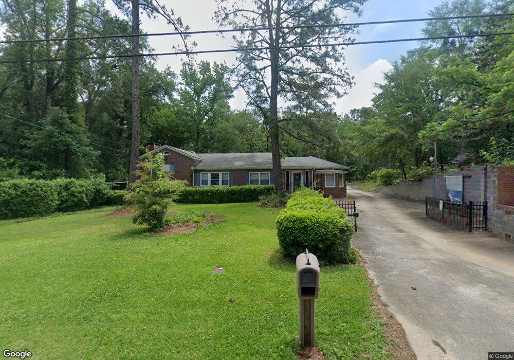
1305 Wesleyan Dr Macon, GA 31210
Estimated Value: $235,000 - $272,000
4
Beds
3
Baths
2,743
Sq Ft
$93/Sq Ft
Est. Value
About This Home
This home is located at 1305 Wesleyan Dr, Macon, GA 31210 and is currently estimated at $254,611, approximately $92 per square foot. 1305 Wesleyan Dr is a home located in Bibb County with nearby schools including Springdale Elementary School, Howard Middle School, and Howard High School.
Ownership History
Date
Name
Owned For
Owner Type
Purchase Details
Closed on
Dec 24, 2014
Sold by
Bean Lena C
Bought by
Bean Lena C
Current Estimated Value
Purchase Details
Closed on
Nov 24, 2014
Sold by
Bean Lena C
Bought by
Bean Lena C and Bean Bernard A
Purchase Details
Closed on
Nov 6, 2014
Sold by
Chapman James D Estate
Bought by
Bean Lena C
Purchase Details
Closed on
May 26, 2010
Sold by
Bean Bernard A
Bought by
Bean Lena C
Create a Home Valuation Report for This Property
The Home Valuation Report is an in-depth analysis detailing your home's value as well as a comparison with similar homes in the area
Home Values in the Area
Average Home Value in this Area
Purchase History
| Date | Buyer | Sale Price | Title Company |
|---|---|---|---|
| Bean Lena C | -- | None Available | |
| Bean Lena C | -- | None Available | |
| Bean Lena C | $1,600 | -- | |
| Bean Lena C | $135,000 | None Available |
Source: Public Records
Tax History Compared to Growth
Tax History
| Year | Tax Paid | Tax Assessment Tax Assessment Total Assessment is a certain percentage of the fair market value that is determined by local assessors to be the total taxable value of land and additions on the property. | Land | Improvement |
|---|---|---|---|---|
| 2025 | $1,559 | $70,436 | $4,135 | $66,301 |
| 2024 | $1,611 | $70,436 | $4,135 | $66,301 |
| 2023 | $1,154 | $70,436 | $4,135 | $66,301 |
| 2022 | $1,984 | $64,314 | $11,858 | $52,456 |
| 2021 | $2,178 | $64,314 | $11,858 | $52,456 |
| 2020 | $2,225 | $64,314 | $11,858 | $52,456 |
| 2019 | $2,244 | $64,314 | $11,858 | $52,456 |
| 2018 | $3,616 | $64,314 | $11,858 | $52,456 |
| 2017 | $2,093 | $62,871 | $11,858 | $51,013 |
| 2016 | $1,933 | $62,871 | $11,858 | $51,013 |
| 2015 | $2,736 | $62,871 | $11,858 | $51,013 |
| 2014 | $2,317 | $54,228 | $5,750 | $48,478 |
Source: Public Records
Map
Nearby Homes
- 1297 Wesleyan Dr
- 108 Hillbrooke Ct
- 199 Springfield Blvd
- 1159 Wesleyan Dr
- 200 N Wesleyan Cir
- 150 Springdale Ct
- 178 Springfield Blvd
- 171 Lake View Dr N
- 920 Wesleyan Dr
- 115 Saddle Run Ct
- 123 Saddle Run Ct
- 4661 N Beechwood Dr
- 1475 Maplewood Dr
- 3658 Northside Dr
- 135 Chadwick Dr
- 4726 Cheryle Ann Dr
- 5161 Wesleyan Cir
- 1317 Wesleyan Dr
- 104 Hillbrooke Ct
- 1291 Wesleyan Dr
- 101 Hillbrooke Ct
- 1321 Wesleyan Dr
- 1327 Wesleyan Dr
- 105 Hillbrooke Ct
- 1287 Wesleyan Dr
- 112 Hillbrooke Ct
- 109 Hillbrooke Ct
- 109 Hillbrooke Ct Unit 19
- 1296 Wesleyan Dr
- 1331 Wesleyan Dr
- 1290 Wesleyan Dr
- 1271 Wesleyan Dr
- 116 Hillbrooke Ct
- 1276 Wesleyan Dr
- 0 Hillbrooke Ct Unit 3274912
- 120 Hillbrooke Ct
- 1264 Wesleyan Dr