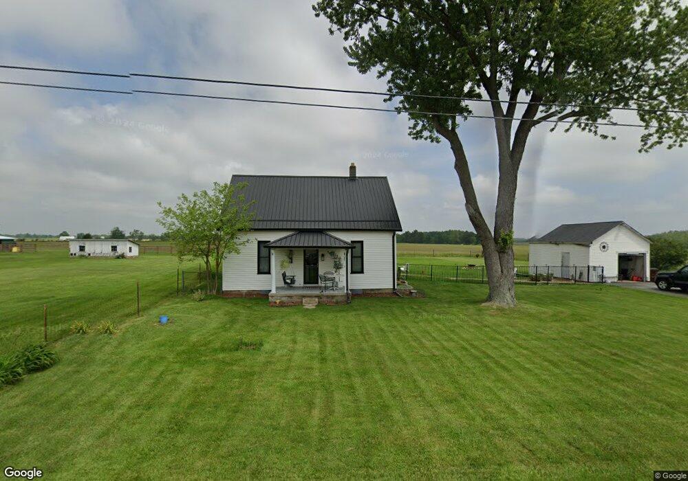
13055 Us Highway 50 W Bainbridge, OH 45612
Estimated Value: $141,000 - $184,000
4
Beds
1
Bath
1,457
Sq Ft
$109/Sq Ft
Est. Value
About This Home
This home is located at 13055 Us Highway 50 W, Bainbridge, OH 45612 and is currently estimated at $158,814, approximately $109 per square foot. 13055 Us Highway 50 W is a home located in Highland County with nearby schools including McClain High School.
Ownership History
Date
Name
Owned For
Owner Type
Purchase Details
Closed on
Mar 21, 2022
Sold by
Ben Benner
Bought by
Webster Regina Ann and Martinis Francis Edwin
Current Estimated Value
Purchase Details
Closed on
Sep 18, 2013
Sold by
Butcher Scott R and Butcher Cherish Mccarty
Bought by
Benner Ben
Home Financials for this Owner
Home Financials are based on the most recent Mortgage that was taken out on this home.
Original Mortgage
$66,673
Interest Rate
4.39%
Mortgage Type
VA
Purchase Details
Closed on
Oct 21, 2005
Sold by
Cooper Teressa and Cooper Scott
Bought by
Butcher Scott R
Home Financials for this Owner
Home Financials are based on the most recent Mortgage that was taken out on this home.
Original Mortgage
$62,800
Interest Rate
5.8%
Mortgage Type
Purchase Money Mortgage
Purchase Details
Closed on
Jan 1, 1990
Bought by
White Danny and White Teressa
Create a Home Valuation Report for This Property
The Home Valuation Report is an in-depth analysis detailing your home's value as well as a comparison with similar homes in the area
Home Values in the Area
Average Home Value in this Area
Purchase History
| Date | Buyer | Sale Price | Title Company |
|---|---|---|---|
| Webster Regina Ann | $102,900 | Northwest Title | |
| Benner Ben | $65,500 | Title First Agency Inc | |
| Butcher Scott R | $62,800 | Technetitle Agency | |
| White Danny | -- | -- |
Source: Public Records
Mortgage History
| Date | Status | Borrower | Loan Amount |
|---|---|---|---|
| Previous Owner | Benner Ben | $66,673 | |
| Previous Owner | Butcher Scott R | $62,800 |
Source: Public Records
Tax History Compared to Growth
Tax History
| Year | Tax Paid | Tax Assessment Tax Assessment Total Assessment is a certain percentage of the fair market value that is determined by local assessors to be the total taxable value of land and additions on the property. | Land | Improvement |
|---|---|---|---|---|
| 2024 | $1,300 | $40,290 | $6,860 | $33,430 |
| 2023 | $1,238 | $27,900 | $5,880 | $22,020 |
| 2022 | $948 | $27,900 | $5,880 | $22,020 |
| 2021 | $901 | $27,900 | $5,880 | $22,020 |
| 2020 | $771 | $23,240 | $4,900 | $18,340 |
| 2019 | $783 | $23,240 | $4,900 | $18,340 |
| 2018 | $700 | $23,240 | $4,900 | $18,340 |
| 2017 | $613 | $17,960 | $4,970 | $12,990 |
| 2016 | $614 | $17,960 | $4,970 | $12,990 |
| 2015 | $638 | $17,960 | $4,970 | $12,990 |
| 2014 | $638 | $17,090 | $4,730 | $12,360 |
| 2013 | $639 | $17,090 | $4,730 | $12,360 |
Source: Public Records
Map
Nearby Homes
- 12977 U S 50
- 6838 McCoppin Mill Rd
- 6935 Laura Blvd
- 7094 Cedar Trail
- 0 Martha Dr Unit 1857951
- 0.459ac Lakefront Dr
- 11850 Maple Trail
- 11245 Karnes Rd
- 6749 Loch Lomond Cir
- 14703 Brier Rd
- 11515 Dundee Dr
- 61 Maple Dr
- 355 Maple Dr
- 0 Maple Dr Unit 1841507
- 7069 Forest Cove Cir
- 7724 Cave Rd
- 6949 Highland Trail W Unit TLW
- acres +- N Beach Rd
- 0 Overman Rd Unit 1837015
- ac Overman Rd
- 13055 U S 50
- 13033 Us Highway 50 W
- 13074 Us Rt 50
- 13074 U S 50
- 13074 Us Highway 50 W
- 13023 U S 50
- 13025 Us Highway 50 W
- 13011 Us Highway 50 W
- 12987 Us Highway 50 W
- 12987 U S 50
- 12981 Us Highway 50 W
- 12977 Us Highway 50 W
- 12973 Us Rt 50
- 12973 Us Highway 50 W
- 12972 Us Highway 50 W
- 12960 Us Highway 50 W
- 12952 Us Highway 50 W
- 12930 Us Highway 50 W
- 12943 Us Highway 50 W
- 12917 Us Highway 50 W