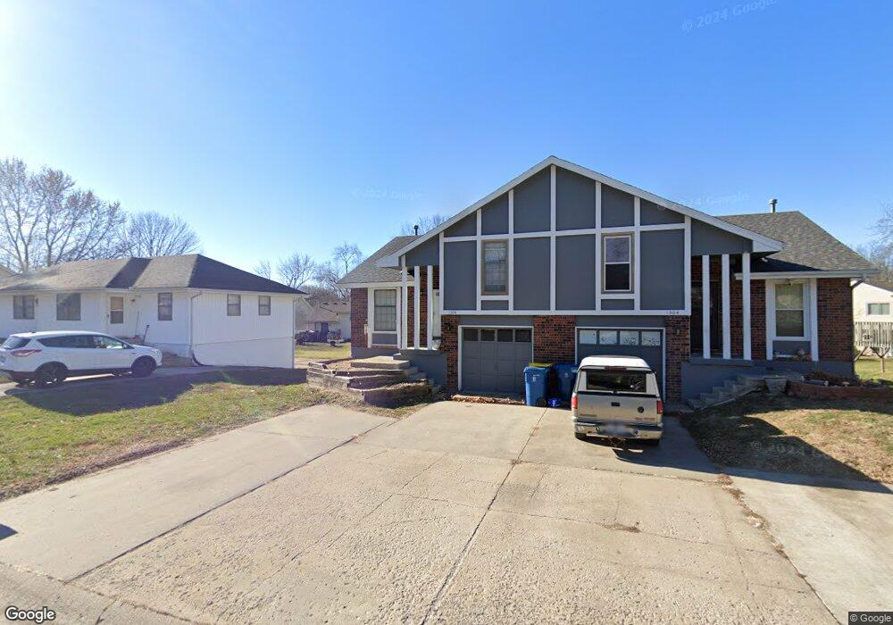
1306 Ada St Kearney, MO 64060
Estimated Value: $274,000 - $308,000
2
Beds
2
Baths
1,732
Sq Ft
$169/Sq Ft
Est. Value
About This Home
This home is located at 1306 Ada St, Kearney, MO 64060 and is currently estimated at $293,524, approximately $169 per square foot. 1306 Ada St is a home located in Clay County with nearby schools including Kearney Junior High School and Kearney High School.
Ownership History
Date
Name
Owned For
Owner Type
Purchase Details
Closed on
Sep 14, 2022
Sold by
Wayne Brownsberger Gary
Bought by
Miller Gretchen L and Miller Michael S
Current Estimated Value
Purchase Details
Closed on
Apr 24, 2017
Sold by
Syas Daniel Lee
Bought by
Brownsberger Gary Wayne
Home Financials for this Owner
Home Financials are based on the most recent Mortgage that was taken out on this home.
Original Mortgage
$52,000
Interest Rate
4.3%
Mortgage Type
New Conventional
Purchase Details
Closed on
Mar 2, 2011
Sold by
Wells Fargo Financial Missouri Inc
Bought by
Syas Daniel L
Purchase Details
Closed on
Dec 2, 2002
Sold by
Byfield William Brian and Byfield Julie C
Bought by
Moon Brett A and Moon Po Y
Home Financials for this Owner
Home Financials are based on the most recent Mortgage that was taken out on this home.
Original Mortgage
$88,000
Interest Rate
6.28%
Mortgage Type
VA
Purchase Details
Closed on
Jul 29, 2002
Sold by
Blair Keith Douglas
Bought by
Brownsberger Gary W
Home Financials for this Owner
Home Financials are based on the most recent Mortgage that was taken out on this home.
Original Mortgage
$91,188
Interest Rate
6.62%
Mortgage Type
VA
Purchase Details
Closed on
Apr 7, 1998
Sold by
Head Tracy Joe and Head Melanie Sue
Bought by
Byfield Julie C
Home Financials for this Owner
Home Financials are based on the most recent Mortgage that was taken out on this home.
Original Mortgage
$65,491
Interest Rate
7.09%
Mortgage Type
FHA
Create a Home Valuation Report for This Property
The Home Valuation Report is an in-depth analysis detailing your home's value as well as a comparison with similar homes in the area
Home Values in the Area
Average Home Value in this Area
Purchase History
We collect this data history from publicly available records. To have your information removed, we recommend requesting removal directly through your county’s website.
| Date | Buyer | Sale Price | Title Company |
|---|---|---|---|
| Miller Gretchen L | -- | -- | |
| Brownsberger Gary Wayne | -- | Alliance Title | |
| Syas Daniel L | -- | None Available | |
| Moon Brett A | -- | Kansas City Title | |
| Brownsberger Gary W | -- | Kansas City Title | |
| Byfield Julie C | -- | -- |
Source: Public Records
Mortgage History
We collect this data history from publicly available records. To have your information removed, we recommend requesting removal directly through your county’s website.
| Date | Status | Borrower | Loan Amount |
|---|---|---|---|
| Previous Owner | Brownsberger Gary Wayne | $52,000 | |
| Previous Owner | Moon Brett A | $88,000 | |
| Previous Owner | Brownsberger Gary W | $91,188 | |
| Previous Owner | Byfield Julie C | $65,491 |
Source: Public Records
Tax History
| Year | Tax Paid | Tax Assessment Tax Assessment Total Assessment is a certain percentage of the fair market value that is determined by local assessors to be the total taxable value of land and additions on the property. | Land | Improvement |
|---|---|---|---|---|
| 2025 | $2,157 | $39,860 | -- | -- |
| 2024 | $2,157 | $31,480 | -- | -- |
| 2023 | $2,150 | $31,480 | $0 | $0 |
| 2022 | $2,005 | $28,390 | $0 | $0 |
| 2021 | $1,966 | $28,386 | $3,800 | $24,586 |
| 2020 | $2,022 | $26,560 | $0 | $0 |
| 2019 | $2,011 | $26,560 | $0 | $0 |
| 2018 | $2,042 | $26,050 | $0 | $0 |
| 2017 | $1,129 | $26,050 | $3,800 | $22,250 |
| 2016 | $1,129 | $14,550 | $3,040 | $11,510 |
| 2015 | $1,129 | $14,550 | $3,040 | $11,510 |
| 2014 | $1,048 | $13,450 | $2,430 | $11,020 |
Source: Public Records
Map
Nearby Homes
- 1301 Ada St
- 406 E 11th St
- 621 E 13th St
- 1107 Halle Dr
- 1206 Noah Ln
- 623 E 13th St
- 1404 Colony Dr
- 905 Oak Ridge
- 903 S Jefferson St
- 1314 Susan St
- 1307 Stonecrest Dr
- 1305 Stonecrest Dr
- 810 Pine Crest Ave
- 1004 Sloan Cir
- 905 Susan St
- 800 E 13th Terrace
- 1104 Regency Dr
- Parcel C State Route 92
- 1708 Marble Dr
- 1709 Park Ln
Your Personal Tour Guide
Ask me questions while you tour the home.