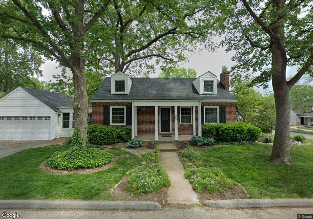
1306 Andrew Dr Saint Louis, MO 63122
Estimated Value: $457,000 - $570,000
4
Beds
2
Baths
1,975
Sq Ft
$265/Sq Ft
Est. Value
About This Home
This home is located at 1306 Andrew Dr, Saint Louis, MO 63122 and is currently estimated at $523,718, approximately $265 per square foot. 1306 Andrew Dr is a home located in St. Louis County with nearby schools including North Glendale Elementary School, Nipher Middle School, and Kirkwood Senior High School.
Ownership History
Date
Name
Owned For
Owner Type
Purchase Details
Closed on
Dec 24, 2014
Sold by
Petraceklongtine Marie E and Petraceklongtine Marie E
Bought by
Longtine Mark S Joint Revocable Livin and Petraceklongtine Marie E
Current Estimated Value
Purchase Details
Closed on
Mar 31, 2005
Sold by
Ojascastro Alejandro R and Ojascastro Lee H
Bought by
Longtine Mark S and Longtine Marie E
Home Financials for this Owner
Home Financials are based on the most recent Mortgage that was taken out on this home.
Original Mortgage
$224,800
Interest Rate
5.78%
Mortgage Type
Purchase Money Mortgage
Purchase Details
Closed on
Oct 29, 2001
Sold by
Hanley Susan K
Bought by
Ojascastro Alejandro R and Ojascastro Lee H
Home Financials for this Owner
Home Financials are based on the most recent Mortgage that was taken out on this home.
Original Mortgage
$150,000
Interest Rate
6.84%
Create a Home Valuation Report for This Property
The Home Valuation Report is an in-depth analysis detailing your home's value as well as a comparison with similar homes in the area
Home Values in the Area
Average Home Value in this Area
Purchase History
| Date | Buyer | Sale Price | Title Company |
|---|---|---|---|
| Longtine Mark S Joint Revocable Livin | -- | -- | |
| Longtine Mark S | $281,000 | -- | |
| Ojascastro Alejandro R | $241,000 | -- |
Source: Public Records
Mortgage History
| Date | Status | Borrower | Loan Amount |
|---|---|---|---|
| Previous Owner | Longtine Mark S | $224,800 | |
| Previous Owner | Ojascastro Alejandro R | $150,000 |
Source: Public Records
Tax History Compared to Growth
Tax History
| Year | Tax Paid | Tax Assessment Tax Assessment Total Assessment is a certain percentage of the fair market value that is determined by local assessors to be the total taxable value of land and additions on the property. | Land | Improvement |
|---|---|---|---|---|
| 2025 | $4,951 | $77,410 | $54,150 | $23,260 |
| 2024 | $4,951 | $75,830 | $38,670 | $37,160 |
| 2023 | $4,951 | $75,830 | $38,670 | $37,160 |
| 2022 | $4,852 | $70,280 | $37,090 | $33,190 |
| 2021 | $4,784 | $70,280 | $37,090 | $33,190 |
| 2020 | $4,362 | $61,300 | $34,810 | $26,490 |
| 2019 | $4,253 | $61,300 | $34,810 | $26,490 |
| 2018 | $3,879 | $50,040 | $27,850 | $22,190 |
| 2017 | $3,908 | $50,040 | $27,850 | $22,190 |
| 2016 | $3,462 | $44,610 | $21,660 | $22,950 |
| 2015 | $3,312 | $44,610 | $21,660 | $22,950 |
| 2014 | $3,792 | $50,010 | $14,270 | $35,740 |
Source: Public Records
Map
Nearby Homes
- 1025 Glenmoor Ln
- 939 Victoria Place
- 1306 Glendale Gardens Dr Unit B
- 1306 Glendale Gardens Dr Unit C
- 65 Ridge Line Dr
- 1509 Andrew Dr
- 830 Victoria Place
- 1629 Andrew Dr
- 1 Dickson Ct
- 1105 Timberlane Dr
- 641 Brookhaven Ct
- 858 Chelsea Ave
- 826 Chelsea Ave
- 1301 Geders Ln
- 1025 North Dr
- 827 Yosemite Dr
- 987 Dwyer Ave
- 28 Berry Road Park
- 754 Brownell Ave
- 946 Dwyer Ave
- 1009 Joanna Ave
- 1000 Nolan Dr
- 1004 Nolan Dr
- 1311 Andrew Dr
- 1303 Andrew Dr
- 1319 Andrew Dr
- 1000 Joanna Ave
- 1008 Nolan Dr
- 1011 Joanna Ave
- 1004 Joanna Ave
- 1325 Andrew Dr
- 1299 Andrew Dr
- 1008 Joanna Ave
- 1012 Nolan Dr
- 1333 Andrew Dr
- 1015 Joanna Ave
- 1291 Andrew Dr
- 1341 Andrew Dr
- 1012 Joanna Ave
- 949 Joanna Ave