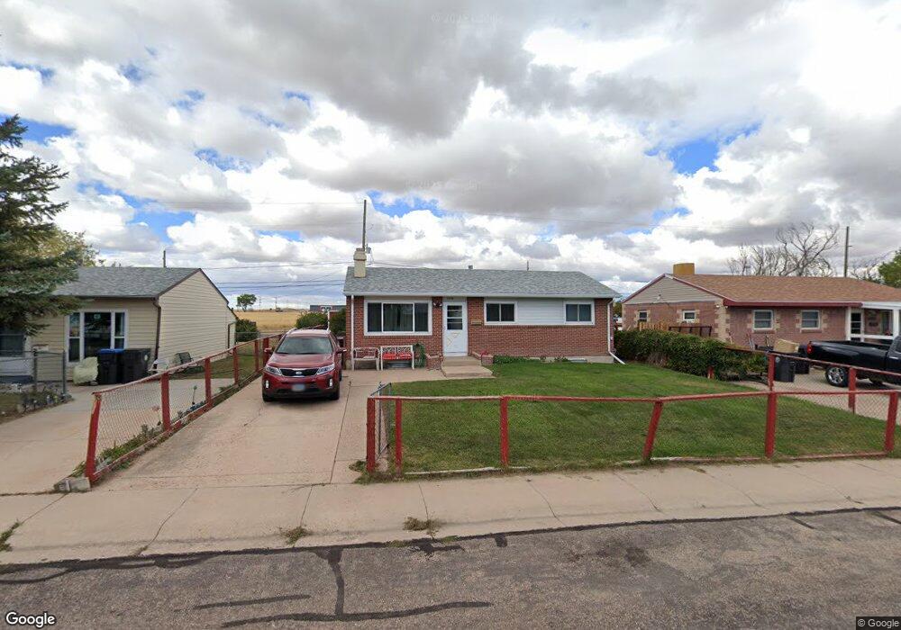
1306 Arp Ave Cheyenne, WY 82007
Estimated Value: $276,000 - $314,774
--
Bed
--
Bath
851
Sq Ft
$341/Sq Ft
Est. Value
About This Home
This home is located at 1306 Arp Ave, Cheyenne, WY 82007 and is currently estimated at $290,444, approximately $341 per square foot. 1306 Arp Ave is a home located in Laramie County with nearby schools including Goins Elementary School, Johnson Junior High School, and South High School.
Ownership History
Date
Name
Owned For
Owner Type
Purchase Details
Closed on
Apr 22, 2024
Sold by
Riggin John B
Bought by
Reed Jesse and Reed Jessica
Current Estimated Value
Home Financials for this Owner
Home Financials are based on the most recent Mortgage that was taken out on this home.
Original Mortgage
$275,805
Outstanding Balance
$271,573
Interest Rate
6.74%
Mortgage Type
VA
Estimated Equity
$18,871
Create a Home Valuation Report for This Property
The Home Valuation Report is an in-depth analysis detailing your home's value as well as a comparison with similar homes in the area
Home Values in the Area
Average Home Value in this Area
Purchase History
| Date | Buyer | Sale Price | Title Company |
|---|---|---|---|
| Reed Jesse | -- | First American | |
| Reed Jesse | -- | First American |
Source: Public Records
Mortgage History
| Date | Status | Borrower | Loan Amount |
|---|---|---|---|
| Open | Reed Jesse | $275,805 | |
| Closed | Reed Jesse | $275,805 |
Source: Public Records
Tax History Compared to Growth
Tax History
| Year | Tax Paid | Tax Assessment Tax Assessment Total Assessment is a certain percentage of the fair market value that is determined by local assessors to be the total taxable value of land and additions on the property. | Land | Improvement |
|---|---|---|---|---|
| 2025 | $1,794 | $18,843 | $2,356 | $16,487 |
| 2024 | $1,794 | $25,368 | $3,142 | $22,226 |
| 2023 | $1,526 | $24,580 | $3,142 | $21,438 |
| 2022 | $1,369 | $21,960 | $3,142 | $18,818 |
| 2021 | $1,143 | $18,795 | $3,142 | $15,653 |
| 2020 | $1,080 | $17,975 | $3,142 | $14,833 |
| 2019 | $1,064 | $17,730 | $3,142 | $14,588 |
| 2018 | $871 | $15,181 | $2,379 | $12,802 |
| 2017 | $824 | $14,415 | $2,379 | $12,036 |
| 2016 | $754 | $13,442 | $2,322 | $11,120 |
| 2015 | $733 | $13,153 | $2,322 | $10,831 |
| 2014 | $699 | $12,615 | $2,322 | $10,293 |
Source: Public Records
Map
Nearby Homes
- TBD Wyott Dr
- 1107 Ahrens Ave
- 154 S Arp Ave
- 1409 W Jefferson Rd
- 1677 Blues Dr
- 1624 Carol Ann Way
- 1639 Elsie Jean Trail
- 1641 Elsie Jean Trail
- 1700 Richard Martin Dr
- 1724 Richard Martin Dr
- 1529 Alyssaelaine Dr
- 316 Hynds Ave
- 251 Hunters Way
- 0 Hellwig Rd
- 302 Abby Rd
- TBD W College Dr
- 731 W 2nd St
- 1210 Concerto Ln
- TBD Snyder Ave
- TBD Broken Arrow Rd