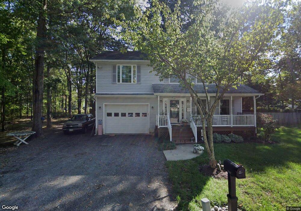
1307 Hawthorne St Shady Side, MD 20764
Estimated Value: $439,000 - $512,000
--
Bed
4
Baths
1,846
Sq Ft
$257/Sq Ft
Est. Value
About This Home
This home is located at 1307 Hawthorne St, Shady Side, MD 20764 and is currently estimated at $475,319, approximately $257 per square foot. 1307 Hawthorne St is a home located in Anne Arundel County with nearby schools including Shady Side Elementary School, Southern Middle School, and Southern High School.
Ownership History
Date
Name
Owned For
Owner Type
Purchase Details
Closed on
Jun 1, 2004
Sold by
Moore Regina H
Bought by
Hurst Wayne L
Current Estimated Value
Purchase Details
Closed on
Oct 10, 2001
Sold by
Moore William T
Bought by
Moore Regina H
Purchase Details
Closed on
Dec 2, 1996
Sold by
H & K Partnership
Bought by
Moore William T and Moore Regina H
Purchase Details
Closed on
Jul 12, 1996
Sold by
Ch & First Baptist Ch Shady Side
Bought by
H & K Partnership
Create a Home Valuation Report for This Property
The Home Valuation Report is an in-depth analysis detailing your home's value as well as a comparison with similar homes in the area
Home Values in the Area
Average Home Value in this Area
Purchase History
| Date | Buyer | Sale Price | Title Company |
|---|---|---|---|
| Hurst Wayne L | $245,000 | -- | |
| Moore Regina H | -- | -- | |
| Moore William T | $138,000 | -- | |
| H & K Partnership | $32,500 | -- |
Source: Public Records
Mortgage History
| Date | Status | Borrower | Loan Amount |
|---|---|---|---|
| Closed | Moore William T | -- |
Source: Public Records
Tax History Compared to Growth
Tax History
| Year | Tax Paid | Tax Assessment Tax Assessment Total Assessment is a certain percentage of the fair market value that is determined by local assessors to be the total taxable value of land and additions on the property. | Land | Improvement |
|---|---|---|---|---|
| 2025 | $3,231 | $364,500 | -- | -- |
| 2024 | $3,231 | $340,700 | $0 | $0 |
| 2023 | $2,517 | $316,900 | $136,100 | $180,800 |
| 2022 | $2,934 | $313,467 | $0 | $0 |
| 2021 | $5,742 | $310,033 | $0 | $0 |
| 2020 | $2,787 | $306,600 | $136,100 | $170,500 |
| 2019 | $2,740 | $297,000 | $0 | $0 |
| 2018 | $2,914 | $287,400 | $0 | $0 |
| 2017 | $2,561 | $277,800 | $0 | $0 |
| 2016 | -- | $275,467 | $0 | $0 |
| 2015 | -- | $273,133 | $0 | $0 |
| 2014 | -- | $270,800 | $0 | $0 |
Source: Public Records
Map
Nearby Homes
- 4913 Chestnut St
- 1302 Spruce St
- 4912 Beech St
- 1419 Shady Rest Rd
- 4908 Aspen St
- 4846 Woods Wharf Rd
- 4992 Lerch Dr
- 4900 Thomas Dr
- 6508 Shady Side Rd
- 4938 Rullman Rd
- 6512 Shady Side Rd
- 4907 Quince St
- 6152 Shady Side Rd
- 0 Shady Side Rd Unit MDAA2113156
- 0 Shady Side Rd Unit MDAA2113166
- 4949 Idlewilde Rd
- 6118 Shady Side Rd
- 1133 Steamboat Rd
- 6070 Shady Side Rd
- 1428 Haile Pkwy
- 1305 Hawthorne St
- 1306 Avalon Blvd
- 1308 Hawthorne St
- 1304 Avalon Blvd
- 1303 Hawthorne St
- 1310 Hawthorne St
- 1306 Hawthorne St
- 1314 Hawthorne St
- 1302 Avalon Blvd
- 1320 Avalon Blvd
- 1301 Hawthorne St
- 1302 Hawthorne St
- 1309 Juniper St
- 1313 Juniper St
- 1307 Juniper St
- 1318 Hawthorne St
- 1305 Juniper St
- 1307 Avalon Blvd
- 1309 Avalon Blvd
- 1315 Juniper St