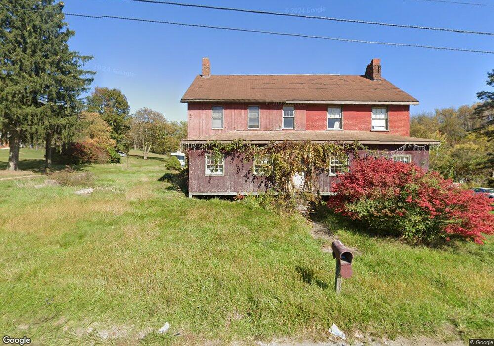
1307 State Route 31 Mount Pleasant, PA 15666
East Huntingdon Township NeighborhoodEstimated Value: $121,510 - $319,000
--
Bed
--
Bath
2,775
Sq Ft
$83/Sq Ft
Est. Value
About This Home
This home is located at 1307 State Route 31, Mount Pleasant, PA 15666 and is currently estimated at $231,628, approximately $83 per square foot. 1307 State Route 31 is a home located in Westmoreland County with nearby schools including Southmoreland Primary Center, Southmoreland Elementary School, and Southmoreland Senior High School.
Ownership History
Date
Name
Owned For
Owner Type
Purchase Details
Closed on
Jan 26, 2009
Sold by
Harper Mark S and Harper Diana L
Bought by
Harper Mark S
Current Estimated Value
Home Financials for this Owner
Home Financials are based on the most recent Mortgage that was taken out on this home.
Original Mortgage
$146,011
Outstanding Balance
$92,099
Interest Rate
5.06%
Mortgage Type
FHA
Estimated Equity
$139,529
Create a Home Valuation Report for This Property
The Home Valuation Report is an in-depth analysis detailing your home's value as well as a comparison with similar homes in the area
Home Values in the Area
Average Home Value in this Area
Purchase History
| Date | Buyer | Sale Price | Title Company |
|---|---|---|---|
| Harper Mark S | -- | None Available |
Source: Public Records
Mortgage History
| Date | Status | Borrower | Loan Amount |
|---|---|---|---|
| Open | Harper Mark S | $146,011 |
Source: Public Records
Tax History Compared to Growth
Tax History
| Year | Tax Paid | Tax Assessment Tax Assessment Total Assessment is a certain percentage of the fair market value that is determined by local assessors to be the total taxable value of land and additions on the property. | Land | Improvement |
|---|---|---|---|---|
| 2025 | $2,528 | $19,840 | $2,350 | $17,490 |
| 2024 | $2,507 | $19,840 | $2,350 | $17,490 |
| 2023 | $2,275 | $19,840 | $2,350 | $17,490 |
| 2022 | $2,176 | $19,840 | $2,350 | $17,490 |
| 2021 | $2,119 | $19,840 | $2,350 | $17,490 |
| 2020 | $2,084 | $19,840 | $2,350 | $17,490 |
| 2019 | $2,004 | $19,840 | $2,350 | $17,490 |
| 2018 | $1,941 | $19,840 | $2,350 | $17,490 |
| 2017 | $1,941 | $19,840 | $2,350 | $17,490 |
| 2016 | $1,898 | $19,840 | $2,350 | $17,490 |
| 2015 | $1,898 | $19,840 | $2,350 | $17,490 |
| 2014 | $1,871 | $19,840 | $2,350 | $17,490 |
Source: Public Records
Map
Nearby Homes
- 15 Braddock Road Ave
- 154 Fire Dept Rd
- 0 Love and Emory Hill Rd
- 7003 State Route 819
- 202 S Quarry St
- 800 W Smithfield St
- 800 W Smithfield St Unit W
- 513 Shannon Dr
- 715 W Walnut St
- 690 Orchard Ave
- 314 College Ave
- 716 Ruffsdale Alverton Rd
- 491 Shannon Dr
- 539 Pine St
- 508 Hemlock St
- 801 Wimbledon Dr
- 35 N Hitchman St
- 0 Mays Ln Unit 22454665
- 6799 Low St
- 126 N Hitchman St
- 1301 State Route 31
- 1299 Route 31
- 1317 State Route 31
- 1295 State Route 31
- 1296 State Route 31
- 1290 State Route 31
- 1327 State Route 31
- 1287 State Route 31
- 1287 State Route 31
- 1329 State Route 31
- 1284 State Route 31
- 1281 State Route 31
- 1281 Pennsylvania 31
- 1337 State Route 31
- 124 Shipley Ln
- 1350 State Route 31
- 1354 Rt 31
- 753 Mulberry Hill Rd
- 753 Mulberry Hill Rd
- 102 Shipley Ln