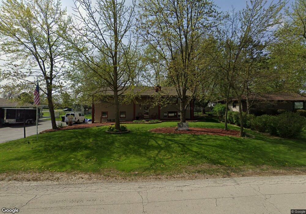
1308 Corrie Ln New Lenox, IL 60451
Estimated Value: $373,000 - $408,000
Studio
--
Bath
--
Sq Ft
19,602
Sq Ft Lot
About This Home
This home is located at 1308 Corrie Ln, New Lenox, IL 60451 and is currently estimated at $383,401. 1308 Corrie Ln is a home located in Will County with nearby schools including Spencer Trail, Spencer Pointe, and Spencer Crossing Intermediate School.
Ownership History
Date
Name
Owned For
Owner Type
Purchase Details
Closed on
Mar 14, 2016
Sold by
Akdille Debra
Bought by
Neville Timothy D
Current Estimated Value
Purchase Details
Closed on
Dec 10, 1993
Sold by
Kuyawa Steven M and Kuyawa Karel F
Bought by
Neville Timothy D and Neville Debra A
Home Financials for this Owner
Home Financials are based on the most recent Mortgage that was taken out on this home.
Original Mortgage
$119,700
Interest Rate
7.15%
Create a Home Valuation Report for This Property
The Home Valuation Report is an in-depth analysis detailing your home's value as well as a comparison with similar homes in the area
Home Values in the Area
Average Home Value in this Area
Purchase History
| Date | Buyer | Sale Price | Title Company |
|---|---|---|---|
| Neville Timothy D | -- | None Available | |
| Neville Timothy D | $133,000 | -- |
Source: Public Records
Mortgage History
| Date | Status | Borrower | Loan Amount |
|---|---|---|---|
| Previous Owner | Neville Timothy D | $119,700 |
Source: Public Records
Tax History
| Year | Tax Paid | Tax Assessment Tax Assessment Total Assessment is a certain percentage of the fair market value that is determined by local assessors to be the total taxable value of land and additions on the property. | Land | Improvement |
|---|---|---|---|---|
| 2024 | $7,533 | $112,280 | $33,360 | $78,920 |
| 2023 | $7,533 | $102,352 | $30,410 | $71,942 |
| 2022 | $7,165 | $94,290 | $28,015 | $66,275 |
| 2021 | $6,987 | $88,677 | $26,347 | $62,330 |
| 2020 | $6,783 | $85,513 | $25,407 | $60,106 |
| 2019 | $6,485 | $82,861 | $24,619 | $58,242 |
| 2018 | $6,330 | $80,004 | $23,770 | $56,234 |
| 2017 | $6,005 | $77,704 | $23,087 | $54,617 |
| 2016 | $5,826 | $75,624 | $22,469 | $53,155 |
| 2015 | $5,598 | $73,244 | $21,762 | $51,482 |
| 2014 | $5,598 | $72,339 | $21,493 | $50,846 |
| 2013 | $5,598 | $73,314 | $21,783 | $51,531 |
Source: Public Records
Map
Nearby Homes
- 22545 S Spencer Rd
- 1825 Brogan Dr
- 1978 Stapleton Rd
- 22600 Country Ct
- 550 E Laraway Rd
- 500 E Laraway Rd
- 1973 Edgeview Dr
- 2019 Royalglen Dr
- 1869 Glenlake Ct
- LOT 8 W Laraway Rd
- 2155 Sky Harbor Dr
- 2157 Sky Harbor Dr
- 2156 Sky Harbor Dr
- 2164 Sky Harbor Dr
- 2174 Sky Harbor Dr
- 2102 Knightsbridge Ln
- 921 Knollside Rd
- Bldg. 58 Glenbrooke Ln Unit 1
- Bldg. 58 Glenbrooke Ln Unit 2
- 2231 Stone Creek Dr
- 1312 Corrie Ln
- 1304 Corrie Ln
- 1805 Briarcliff Dr
- 1800 Spencer Rd
- 1804 Spencer Rd
- 1809 Briarcliff Dr
- 1309 Corrie Ln
- 1400 Corrie Ln
- 1313 Corrie Ln
- 1305 Corrie Ln
- 1808 Spencer Rd
- 1804 Briarcliff Dr
- 1317 Corrie Ln
- 1301 Corrie Ln
- 1813 Briarcliff Dr
- 1404 Corrie Ln
- 1812 Spencer Rd
- 1401 Corrie Ln
- 1812 S Spencer Rd
- 1808 Briarcliff Dr
Your Personal Tour Guide
Ask me questions while you tour the home.