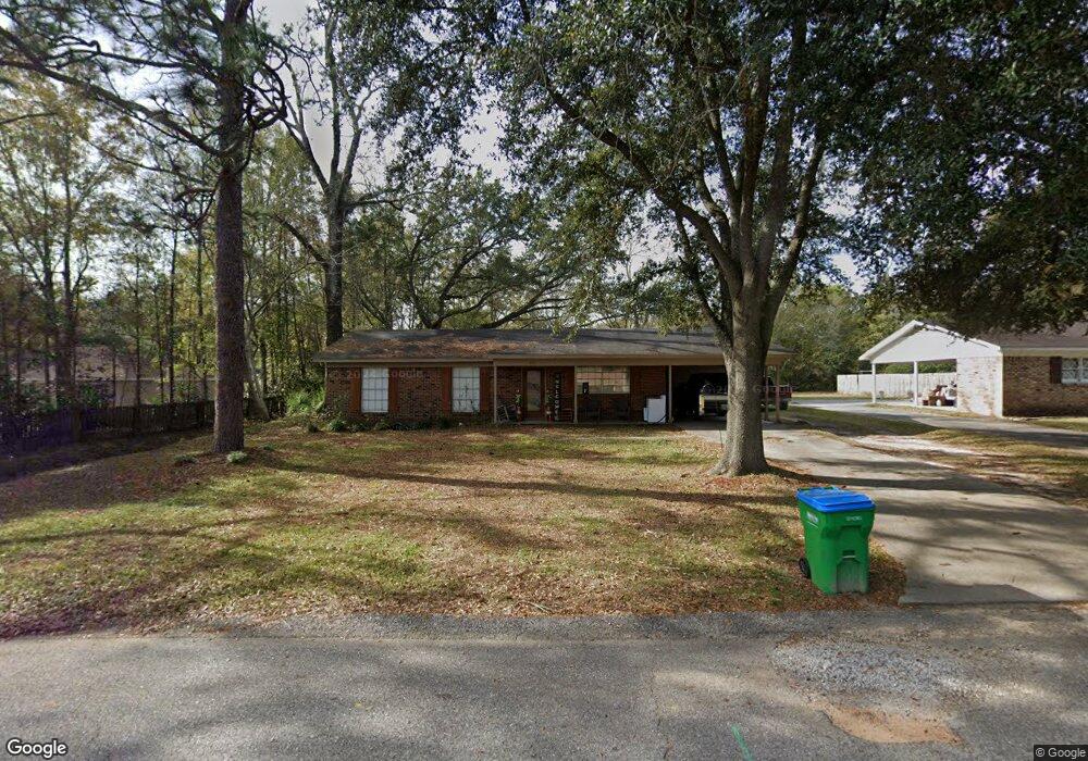
131 Bemis St Saraland, AL 36571
Estimated Value: $178,000 - $274,000
3
Beds
2
Baths
1,273
Sq Ft
$166/Sq Ft
Est. Value
About This Home
This home is located at 131 Bemis St, Saraland, AL 36571 and is currently estimated at $211,262, approximately $165 per square foot. 131 Bemis St is a home located in Mobile County with nearby schools including Saraland Elementary School, Nelson Leon Adams Middle School/Saraland Middle School, and Saraland High School.
Ownership History
Date
Name
Owned For
Owner Type
Purchase Details
Closed on
Dec 4, 2017
Sold by
Herring Nathan and Herring G
Bought by
Foster Jonathan P and Foster Heather R
Current Estimated Value
Home Financials for this Owner
Home Financials are based on the most recent Mortgage that was taken out on this home.
Original Mortgage
$151,210
Outstanding Balance
$127,641
Interest Rate
4.4%
Mortgage Type
FHA
Estimated Equity
$83,621
Purchase Details
Closed on
Aug 4, 2010
Sold by
Otto Anna Keller
Bought by
Herring Nathan and Gorodetzer Ashley M
Purchase Details
Closed on
Jun 20, 1990
Sold by
Keller Edward S
Bought by
Keller Charles W
Create a Home Valuation Report for This Property
The Home Valuation Report is an in-depth analysis detailing your home's value as well as a comparison with similar homes in the area
Home Values in the Area
Average Home Value in this Area
Purchase History
| Date | Buyer | Sale Price | Title Company |
|---|---|---|---|
| Foster Jonathan P | $1,540,000 | None Available | |
| Herring Nathan | $50,600 | None Available | |
| Keller Charles W | -- | -- |
Source: Public Records
Mortgage History
| Date | Status | Borrower | Loan Amount |
|---|---|---|---|
| Open | Foster Jonathan P | $151,210 |
Source: Public Records
Tax History
| Year | Tax Paid | Tax Assessment Tax Assessment Total Assessment is a certain percentage of the fair market value that is determined by local assessors to be the total taxable value of land and additions on the property. | Land | Improvement |
|---|---|---|---|---|
| 2025 | $917 | $16,530 | $2,400 | $14,130 |
| 2024 | $917 | $16,050 | $2,400 | $13,650 |
| 2023 | $925 | $16,670 | $2,520 | $14,150 |
| 2022 | $893 | $16,120 | $2,250 | $13,870 |
| 2021 | $826 | $14,980 | $1,800 | $13,180 |
| 2020 | $730 | $13,400 | $1,500 | $11,900 |
| 2019 | $716 | $13,160 | $0 | $0 |
| 2018 | $561 | $10,560 | $0 | $0 |
| 2017 | $561 | $10,560 | $0 | $0 |
| 2016 | $572 | $10,740 | $0 | $0 |
| 2013 | $333 | $7,620 | $0 | $0 |
Source: Public Records
Map
Nearby Homes
- 219 Bemis St
- 221 Bemis St
- 223 Bemis St
- 205 Stauffer Ave
- 503 Shelton Beach Rd
- 114 Melinda Dr
- 30 Melinda Dr
- 217 Stauffer Ave
- 319 Villa Oaks Dr
- 456 Scott Dr
- 328 Villa Oaks Dr
- 159 Courtaulds Ave
- 136 Mathieson Ave
- 234 Autumn Dr
- 487 Scott Dr
- 807 Timber Ln
- 505 Norton Ave
- 832 Joaneen Dr
- 717 Ann St
- 705 Gilbert St
Your Personal Tour Guide
Ask me questions while you tour the home.