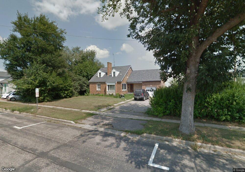
131 Maine St Mauston, WI 53948
Estimated Value: $137,000 - $223,000
4
Beds
2
Baths
1,849
Sq Ft
$98/Sq Ft
Est. Value
About This Home
This home is located at 131 Maine St, Mauston, WI 53948 and is currently estimated at $180,372, approximately $97 per square foot. 131 Maine St is a home located in Juneau County with nearby schools including West Side Elementary School, Lyndon Station Elementary School, and Grayside Elementary School.
Ownership History
Date
Name
Owned For
Owner Type
Purchase Details
Closed on
Sep 2, 2020
Sold by
Mcr Limited Llc A Florida Limited Liabil
Bought by
Price Jesse R
Current Estimated Value
Purchase Details
Closed on
Dec 29, 2005
Sold by
Secretary Of Veterans Affairs
Bought by
Reyes Maritza
Purchase Details
Closed on
Apr 28, 2005
Sold by
Washington Mutual Bank Fa
Bought by
Department Of Veterans Affairs
Purchase Details
Closed on
Apr 6, 2005
Sold by
Johnson Judith A
Bought by
Washington Mutual Bank Fa
Create a Home Valuation Report for This Property
The Home Valuation Report is an in-depth analysis detailing your home's value as well as a comparison with similar homes in the area
Home Values in the Area
Average Home Value in this Area
Purchase History
| Date | Buyer | Sale Price | Title Company |
|---|---|---|---|
| Price Jesse R | $76,500 | -- | |
| Reyes Maritza | $50,000 | -- | |
| Department Of Veterans Affairs | $61,700 | -- | |
| Washington Mutual Bank Fa | $61,700 | -- |
Source: Public Records
Tax History Compared to Growth
Tax History
| Year | Tax Paid | Tax Assessment Tax Assessment Total Assessment is a certain percentage of the fair market value that is determined by local assessors to be the total taxable value of land and additions on the property. | Land | Improvement |
|---|---|---|---|---|
| 2024 | $2,880 | $119,200 | $9,200 | $110,000 |
| 2023 | $2,621 | $119,200 | $9,200 | $110,000 |
| 2022 | $2,582 | $119,200 | $9,200 | $110,000 |
| 2021 | $2,409 | $80,600 | $7,700 | $72,900 |
| 2020 | $2,361 | $80,600 | $7,700 | $72,900 |
| 2019 | $2,334 | $80,600 | $7,700 | $72,900 |
| 2018 | $2,259 | $80,600 | $7,700 | $72,900 |
| 2017 | $2,239 | $80,600 | $7,700 | $72,900 |
| 2016 | $2,363 | $80,600 | $7,700 | $72,900 |
| 2015 | $2,454 | $80,600 | $7,700 | $72,900 |
| 2014 | $2,314 | $80,600 | $7,700 | $72,900 |
| 2013 | $1,240 | $42,700 | $7,700 | $35,000 |
Source: Public Records
Map
Nearby Homes
- 108 Hanover St
- 0 Fleet St Unit 1978417
- 234 Tremont St
- 12.35 AC Highway 58 Trunk
- 318 Tremont St
- 415 West Ave
- 202 Wisconsin St
- 506 W State St
- 120 W Milwaukee St
- 420 E Monroe St
- 722 E State St
- L5 Buttner Ct
- 0.3 acres Lincoln St
- 207 Highview Ave
- 810 S Hickory St
- 813 S Hickory St
- 1.6 acres Prospect and Lincoln St
- 0.53 acres Prospect Ave
- 914 Marshall Dr
- Lot 47 Turner Dr
- 121 Division St
- 132 Elm St
- 123 Division St Unit 4
- 140 Maine St
- W5597 State Route 82 E
- 20 AC State Route 82 E
- 12.05 Ac Wisconsin 58
- 12.05 Acres Wisconsin 58
- 0 State Route 82 E
- 72 Acres Wisconsin 58
- 72 Ac Wisconsin 58
- LC Wisconsin 58
- N1164 Wisconsin 58
- 142 Maine St
- 114 W State St
- 40 Ac Wisconsin 58
- 165 Ac State Route 82 E
- 165 acres State Route 82 E
- 40 Ac State Route 82 E
- 40 acres State Route 82 E