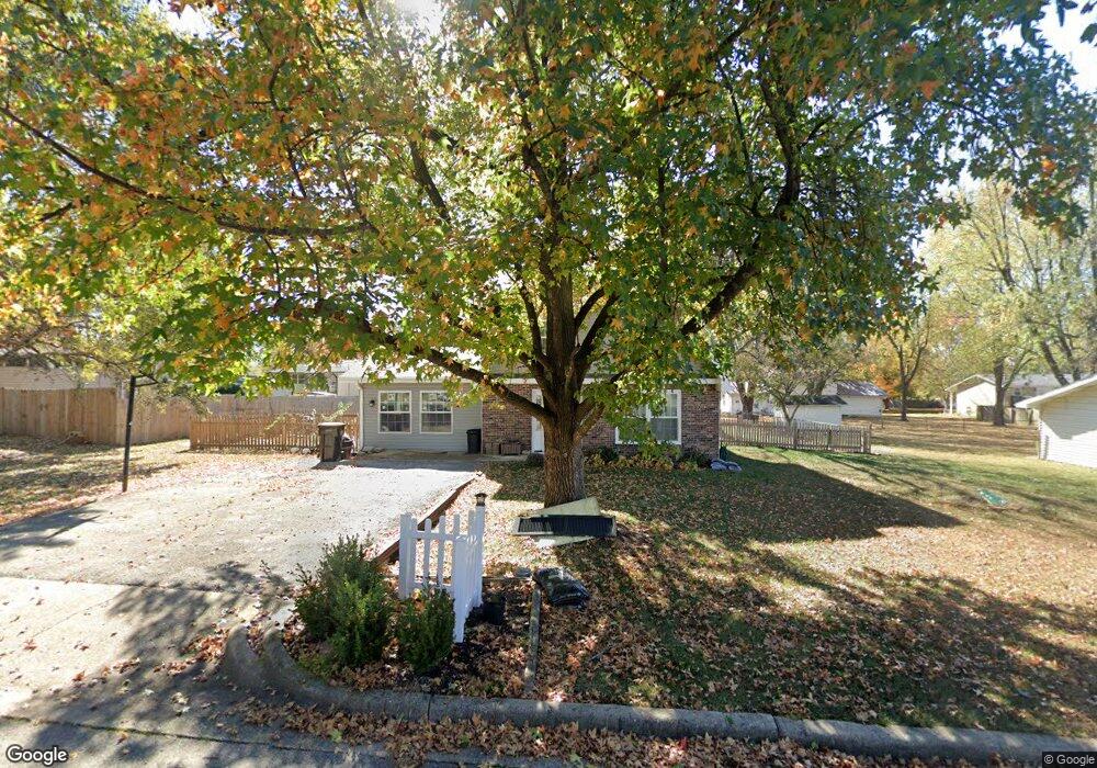
131 Northgate Dr Lebanon, MO 65536
Estimated Value: $160,908 - $222,000
3
Beds
2
Baths
1,583
Sq Ft
$113/Sq Ft
Est. Value
About This Home
This home is located at 131 Northgate Dr, Lebanon, MO 65536 and is currently estimated at $178,977, approximately $113 per square foot. 131 Northgate Dr is a home located in Laclede County with nearby schools including Joe D. Esther Elementary School, Boswell Elementary School, and Maplecrest Elementary School.
Ownership History
Date
Name
Owned For
Owner Type
Purchase Details
Closed on
Apr 26, 2016
Sold by
Carrington Mortgage Services Llc
Bought by
Mcgrath Kathleen
Current Estimated Value
Purchase Details
Closed on
Dec 30, 2015
Sold by
Ivey Candy L
Bought by
Carrington Mortgage Services Llc
Purchase Details
Closed on
Oct 28, 2008
Sold by
Chitwood Kendall A
Bought by
Ivey Candy L
Home Financials for this Owner
Home Financials are based on the most recent Mortgage that was taken out on this home.
Original Mortgage
$75,541
Interest Rate
5.83%
Mortgage Type
FHA
Create a Home Valuation Report for This Property
The Home Valuation Report is an in-depth analysis detailing your home's value as well as a comparison with similar homes in the area
Home Values in the Area
Average Home Value in this Area
Purchase History
| Date | Buyer | Sale Price | Title Company |
|---|---|---|---|
| Mcgrath Kathleen | $46,000 | Land Title & Closing | |
| Carrington Mortgage Services Llc | $44,895 | None Available | |
| Ivey Candy L | -- | None Available |
Source: Public Records
Mortgage History
| Date | Status | Borrower | Loan Amount |
|---|---|---|---|
| Previous Owner | Ivey Candy L | $75,541 |
Source: Public Records
Tax History Compared to Growth
Tax History
| Year | Tax Paid | Tax Assessment Tax Assessment Total Assessment is a certain percentage of the fair market value that is determined by local assessors to be the total taxable value of land and additions on the property. | Land | Improvement |
|---|---|---|---|---|
| 2025 | $786 | $15,410 | $0 | $0 |
| 2024 | $786 | $13,790 | $0 | $0 |
| 2023 | $810 | $13,790 | $0 | $0 |
| 2022 | $755 | $13,790 | $0 | $0 |
| 2021 | $831 | $13,794 | $1,786 | $12,008 |
| 2020 | $836 | $13,794 | $1,786 | $12,008 |
| 2019 | $800 | $13,800 | $1,790 | $12,010 |
| 2018 | $751 | $13,800 | $1,790 | $12,010 |
| 2017 | $668 | $13,790 | $0 | $0 |
| 2016 | $668 | $13,790 | $0 | $0 |
| 2015 | $668 | $13,790 | $0 | $0 |
| 2014 | $668 | $12,940 | $0 | $0 |
| 2013 | -- | $12,940 | $0 | $0 |
Source: Public Records
Map
Nearby Homes
- 600 Hunters Creek Dr
- 605 Hunters Creek Dr
- 231 Raef Rd
- 100 S Bend Rd
- 750 Lynn St
- 1075 Lynn St
- 1540 Woodhill Dr
- 376 Sunset Dr
- 328 Driftwood Dr
- 1520 Fairfield Dr
- 708 Herndon Rd
- TBD Honeysuckle Cir
- 20198 Granger Ln
- 545 Woody
- 116 Smith Rd
- 1075 Kenoly St
- 282 Brice St
- 680 Clark Ave
- 1250 N Jefferson Ave
- 105 S King St
- 127 Northgate Dr
- 135 Northgate Dr
- 124 Brook St
- 120 Brook St
- 128 Brook St
- 128 Northgate Dr
- 123 Northgate Dr
- 139 Northgate Dr
- 124 Northgate Dr
- 132 Northgate Dr
- 116 Brook St
- 132 Brook St
- 120 Northgate Dr
- 119 Northgate Dr
- 136 Northgate Dr
- 25785 Highway 5
- 143 Northgate Dr
- 131 Brook St
- 127 Brook St
- 116 Northgate Dr