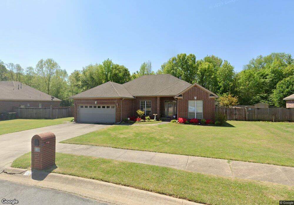
131 Obsidian Dr Sherwood, AR 72120
Estimated Value: $295,000 - $319,000
--
Bed
2
Baths
2,036
Sq Ft
$150/Sq Ft
Est. Value
About This Home
This home is located at 131 Obsidian Dr, Sherwood, AR 72120 and is currently estimated at $305,507, approximately $150 per square foot. 131 Obsidian Dr is a home located in Pulaski County with nearby schools including Oakbrooke Elementary School, Sylvan Hills Middle School, and Sylvan Hills High School.
Ownership History
Date
Name
Owned For
Owner Type
Purchase Details
Closed on
Mar 8, 2023
Sold by
Colbert Betty
Bought by
Colbert Betty L
Current Estimated Value
Purchase Details
Closed on
Feb 28, 2006
Sold by
Byrd Windle and Byrd Marilan M
Bought by
Colbert Kenneth W
Home Financials for this Owner
Home Financials are based on the most recent Mortgage that was taken out on this home.
Original Mortgage
$214,347
Interest Rate
6.19%
Mortgage Type
Fannie Mae Freddie Mac
Create a Home Valuation Report for This Property
The Home Valuation Report is an in-depth analysis detailing your home's value as well as a comparison with similar homes in the area
Home Values in the Area
Average Home Value in this Area
Purchase History
| Date | Buyer | Sale Price | Title Company |
|---|---|---|---|
| Colbert Betty L | -- | -- | |
| Colbert Kenneth W | $208,000 | United Abstract & Title Co I |
Source: Public Records
Mortgage History
| Date | Status | Borrower | Loan Amount |
|---|---|---|---|
| Previous Owner | Colbert Kenneth W | $214,347 |
Source: Public Records
Tax History Compared to Growth
Tax History
| Year | Tax Paid | Tax Assessment Tax Assessment Total Assessment is a certain percentage of the fair market value that is determined by local assessors to be the total taxable value of land and additions on the property. | Land | Improvement |
|---|---|---|---|---|
| 2025 | $1,978 | $50,196 | $7,600 | $42,596 |
| 2024 | $1,978 | $50,196 | $7,600 | $42,596 |
| 2023 | $1,978 | $50,196 | $7,600 | $42,596 |
| 2022 | $2,231 | $50,196 | $7,600 | $42,596 |
| 2021 | $2,161 | $39,650 | $7,160 | $32,490 |
| 2020 | $1,777 | $39,650 | $7,160 | $32,490 |
| 2019 | $1,777 | $39,650 | $7,160 | $32,490 |
| 2018 | $1,802 | $39,650 | $7,160 | $32,490 |
| 2017 | $1,802 | $39,650 | $7,160 | $32,490 |
| 2016 | $1,802 | $41,570 | $7,260 | $34,310 |
| 2015 | $1,928 | $37,962 | $7,260 | $30,702 |
| 2014 | $1,928 | $37,962 | $7,260 | $30,702 |
Source: Public Records
Map
Nearby Homes
- 124 Obsidian Dr
- 119 Riverstone Cove
- 109 Carnelian Dr
- 2712 E Maryland Ave
- 112 Riverstone Cove
- 2724 E Maryland Ave
- 604 Grandview St
- 2243 E Maryland Ave
- 124 Riverstone Cove
- 608 Hemphill Rd
- 3116 Maxine Ave
- 107 Summer Shade Ln
- 8416 E Woodruff Ave
- 115 Jessica Dr
- 8340 Sapphire Cove
- Lot 2 Witts Dr
- Lot 1 Witts Dr
- 114 May St
- 656 Feldspar Dr
- 309 May St
- 123 Obsidian Dr
- 137 Obsidian Dr
- 132 Obsidian Dr
- 0 Obsidian Dr Unit 17015543
- 0 Obsidian Dr Unit 20035920
- 119 Obsidian Dr
- 143 Obsidian Dr
- 116 Obsidian Dr
- 113 Obsidian Dr
- 149 Obsidian Dr
- 108 Obsidian Dr
- 148 Obsidian Dr
- 105 Obsidian Dr
- 153 Obsidian Dr
- 117 Sandstone Cove
- 100 Sandstone Cove
- 156 Obsidian Dr
- 131 Stonehill Dr
- 159 Obsidian Dr
- 115 Stonehill Dr