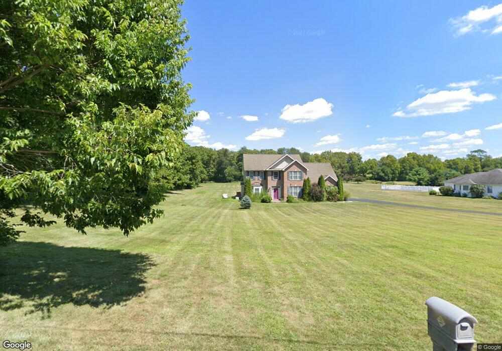
131 S Locust Point Rd Mechanicsburg, PA 17055
Estimated Value: $546,000 - $692,000
4
Beds
3
Baths
2,925
Sq Ft
$218/Sq Ft
Est. Value
About This Home
This home is located at 131 S Locust Point Rd, Mechanicsburg, PA 17055 and is currently estimated at $639,008, approximately $218 per square foot. 131 S Locust Point Rd is a home located in Cumberland County with nearby schools including Monroe Elementary School, Eagle View Middle School, and Cumberland Valley High School.
Ownership History
Date
Name
Owned For
Owner Type
Purchase Details
Closed on
Aug 15, 2008
Sold by
Hebel Enterprises
Bought by
Murray Michael L
Current Estimated Value
Purchase Details
Closed on
Apr 26, 2005
Sold by
Simmons Samuel
Bought by
Hurley Kenneth
Create a Home Valuation Report for This Property
The Home Valuation Report is an in-depth analysis detailing your home's value as well as a comparison with similar homes in the area
Home Values in the Area
Average Home Value in this Area
Purchase History
| Date | Buyer | Sale Price | Title Company |
|---|---|---|---|
| Murray Michael L | $389,900 | -- | |
| Hurley Kenneth | $15,000 | -- |
Source: Public Records
Tax History Compared to Growth
Tax History
| Year | Tax Paid | Tax Assessment Tax Assessment Total Assessment is a certain percentage of the fair market value that is determined by local assessors to be the total taxable value of land and additions on the property. | Land | Improvement |
|---|---|---|---|---|
| 2025 | $6,125 | $395,900 | $92,600 | $303,300 |
| 2024 | $5,814 | $395,900 | $92,600 | $303,300 |
| 2023 | $5,507 | $395,900 | $92,600 | $303,300 |
| 2022 | $5,365 | $395,900 | $92,600 | $303,300 |
| 2021 | $5,244 | $395,900 | $92,600 | $303,300 |
| 2020 | $5,142 | $395,900 | $92,600 | $303,300 |
| 2019 | $5,021 | $395,900 | $92,600 | $303,300 |
| 2018 | $4,922 | $395,900 | $92,600 | $303,300 |
| 2017 | $4,830 | $395,900 | $92,600 | $303,300 |
| 2016 | -- | $395,900 | $92,600 | $303,300 |
| 2015 | -- | $395,900 | $92,600 | $303,300 |
| 2014 | -- | $395,900 | $92,600 | $303,300 |
Source: Public Records
Map
Nearby Homes
- 1221 Minnich Rd
- Emersyn Plan at Brindle Farms Estates
- Woodvale Plan at Brindle Farms Estates
- Cartwright Plan at Brindle Farms Estates
- Abigail Plan at Brindle Farms Estates
- Hudson Plan at Brindle Farms Estates
- Leighton Plan at Brindle Farms Estates
- Huntleigh Plan at Brindle Farms Estates
- Ashland Plan at Brindle Farms Estates
- 723 Brindle Farm Ln
- 724 Brindle Farm Ln
- 253 Brindle Rd
- 220 Maple Ln
- Charlotte Plan at Trindle Place
- Wesley Plan at Trindle Place
- Kingston Plan at Trindle Place
- Hunter Plan at Trindle Place
- Stonecroft Plan at Trindle Place
- Darien Plan at Trindle Place
- Brookfield Plan at Trindle Place
- 139 S Locust Point Rd
- 130 S Locust Point Rd
- 128 S Locust Point Rd
- 124 S Locust Point Rd
- 140 S Locust Point Rd
- 126A S Locust Point Rd
- 126 S Locust Point Rd
- 149 S Locust Point Rd
- 960 Boiling Springs Rd
- 155 S Locust Point Rd
- 955 Boiling Springs Rd
- 71 S Locust Point Rd
- 71 S Locust Point Rd
- 72 S Locust Point Rd
- 1055 Highfield Ct
- 1035 Highfield Ct
- 133 Ryegate Rd
- 1030 Highfield Ct
- 1025 Highfield Ct
- 190 S Locust Point Rd