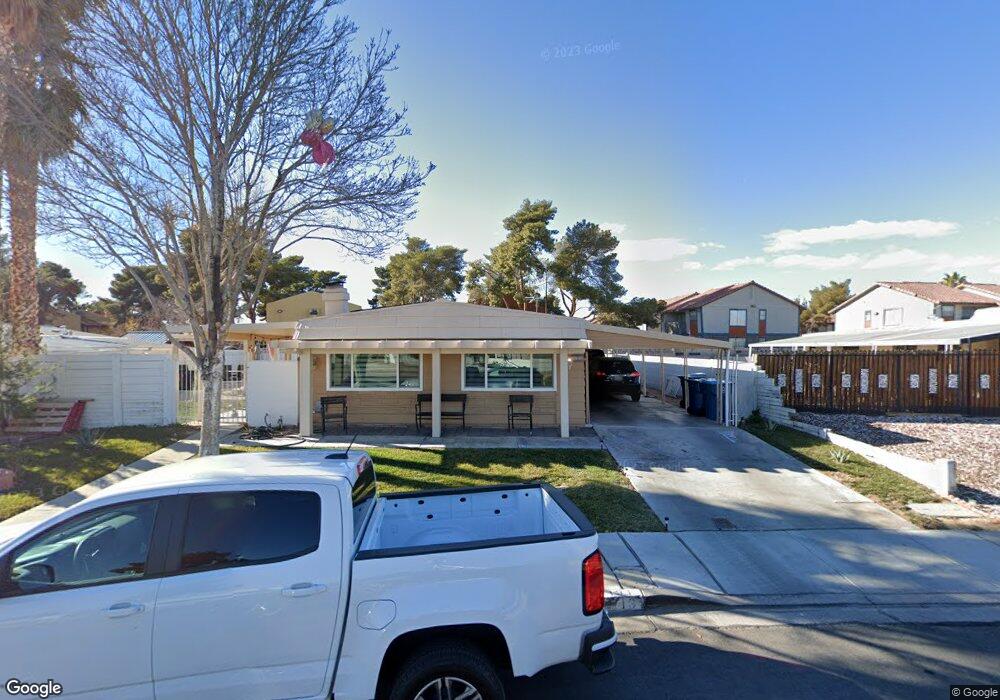
131 Sir George Dr Unit 2 Las Vegas, NV 89110
Estimated Value: $251,000 - $295,000
2
Beds
2
Baths
1,430
Sq Ft
$187/Sq Ft
Est. Value
About This Home
This home is located at 131 Sir George Dr Unit 2, Las Vegas, NV 89110 and is currently estimated at $266,796, approximately $186 per square foot. 131 Sir George Dr Unit 2 is a home located in Clark County with nearby schools including Charlotte & Jerry Keller Elementary School, Richard J. Rundle Elementary School, and Duane D. Keller Middle School.
Ownership History
Date
Name
Owned For
Owner Type
Purchase Details
Closed on
Aug 28, 2025
Sold by
Gonzalez Saul Ruben Avila and Avila Gina Chavez
Bought by
Avila Family Trust and Gonzalez
Current Estimated Value
Purchase Details
Closed on
Apr 30, 2002
Sold by
Phillips George D and Phillips Carolyn E
Bought by
Avila Saul and Avila Gina
Home Financials for this Owner
Home Financials are based on the most recent Mortgage that was taken out on this home.
Original Mortgage
$85,950
Interest Rate
7.13%
Create a Home Valuation Report for This Property
The Home Valuation Report is an in-depth analysis detailing your home's value as well as a comparison with similar homes in the area
Home Values in the Area
Average Home Value in this Area
Purchase History
| Date | Buyer | Sale Price | Title Company |
|---|---|---|---|
| Avila Family Trust | -- | None Listed On Document | |
| Avila Saul | $90,500 | Lawyers Title |
Source: Public Records
Mortgage History
| Date | Status | Borrower | Loan Amount |
|---|---|---|---|
| Previous Owner | Avila Saul | $85,950 |
Source: Public Records
Tax History Compared to Growth
Tax History
| Year | Tax Paid | Tax Assessment Tax Assessment Total Assessment is a certain percentage of the fair market value that is determined by local assessors to be the total taxable value of land and additions on the property. | Land | Improvement |
|---|---|---|---|---|
| 2025 | $555 | $41,129 | $22,400 | $18,729 |
| 2024 | $514 | $41,129 | $22,400 | $18,729 |
| 2023 | $514 | $35,248 | $18,550 | $16,698 |
| 2022 | $476 | $30,642 | $14,700 | $15,942 |
| 2021 | $441 | $29,274 | $13,650 | $15,624 |
| 2020 | $407 | $28,241 | $12,250 | $15,991 |
| 2019 | $381 | $26,083 | $9,800 | $16,283 |
| 2018 | $364 | $24,639 | $8,400 | $16,239 |
| 2017 | $600 | $20,014 | $6,650 | $13,364 |
| 2016 | $342 | $19,091 | $5,250 | $13,841 |
| 2015 | $340 | $19,292 | $4,900 | $14,392 |
| 2014 | $330 | $12,128 | $4,200 | $7,928 |
Source: Public Records
Map
Nearby Homes
- 136 Sir George Dr
- 153 Sir Thomas Dr
- 130 Bel Port Dr Unit 133
- 179 Sir George Dr
- 140 Sir David Way
- 111 Sir Arthur Dr
- 5330 E Charleston Blvd Unit 2
- 5330 E Charleston Blvd Unit 113
- 0 E Charleston Blvd
- 280 Sir Phillip St
- 147 N Christy Ln
- 4928 Ronan Dr
- 332 Sir Jeffery Cir
- 1200 Pleasant Brook St
- 1224 Pleasant Brook St
- 360 Sir Richard Dr E
- 5353 Hollow Brook Ave
- 5564 Orchard Ln Unit 133
- 5600 Orchard Ln
- 5583 Orchard Ln Unit 152
- 129 Sir George Dr
- 206 Bel Port Dr
- 211 Bel Port Dr
- 127 Sir George Dr
- 135 Sir George Dr
- 204 Bel Port Dr
- 213 Bel Port Dr
- 130 Sir George Dr
- 203 Bel Port Dr
- 210 Bel Port Dr Unit 216
- 210 Bel Port Dr Unit 214
- 210 Bel Port Dr Unit 215
- 210 Bel Port Dr Unit 212
- 210 Bel Port Dr Unit 213
- 132 Sir George Dr
- 128 Sir George Dr
- 156 Bel Port Dr
- 200 Bel Port Dr Unit 204
- 200 Bel Port Dr Unit 203
- 200 Bel Port Dr Unit 201