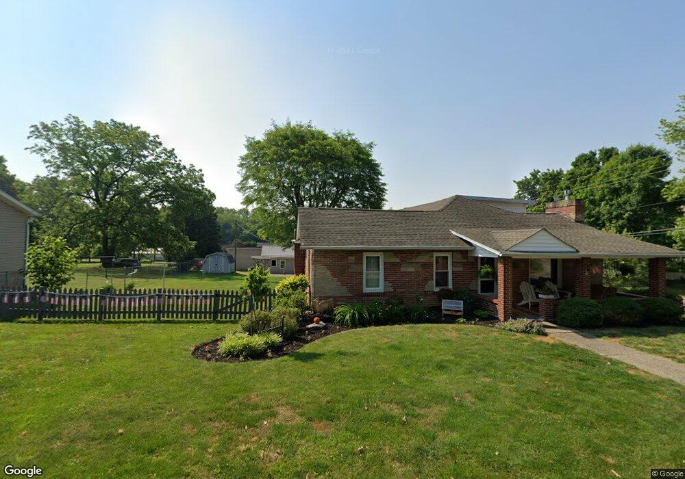
131 W Sheridan Ave Somerset, OH 43783
Estimated Value: $266,000 - $313,000
4
Beds
2
Baths
1,440
Sq Ft
$198/Sq Ft
Est. Value
About This Home
This home is located at 131 W Sheridan Ave, Somerset, OH 43783 and is currently estimated at $284,420, approximately $197 per square foot. 131 W Sheridan Ave is a home located in Perry County with nearby schools including Sheridan High School and Holy Trinity Elementary School.
Ownership History
Date
Name
Owned For
Owner Type
Purchase Details
Closed on
Feb 18, 2012
Sold by
Flautt Doris E and Forsythe Carolyn S
Bought by
Wilson Ronald E and Wilson Janet S
Current Estimated Value
Home Financials for this Owner
Home Financials are based on the most recent Mortgage that was taken out on this home.
Original Mortgage
$116,000
Outstanding Balance
$79,472
Interest Rate
3.89%
Mortgage Type
New Conventional
Estimated Equity
$204,948
Create a Home Valuation Report for This Property
The Home Valuation Report is an in-depth analysis detailing your home's value as well as a comparison with similar homes in the area
Home Values in the Area
Average Home Value in this Area
Purchase History
| Date | Buyer | Sale Price | Title Company |
|---|---|---|---|
| Wilson Ronald E | $145,000 | None Available |
Source: Public Records
Mortgage History
| Date | Status | Borrower | Loan Amount |
|---|---|---|---|
| Open | Wilson Ronald E | $116,000 |
Source: Public Records
Tax History Compared to Growth
Tax History
| Year | Tax Paid | Tax Assessment Tax Assessment Total Assessment is a certain percentage of the fair market value that is determined by local assessors to be the total taxable value of land and additions on the property. | Land | Improvement |
|---|---|---|---|---|
| 2024 | $2,760 | $71,470 | $9,820 | $61,650 |
| 2023 | $2,760 | $71,470 | $9,820 | $61,650 |
| 2022 | $2,248 | $48,530 | $6,130 | $42,400 |
| 2021 | $2,061 | $48,530 | $6,130 | $42,400 |
| 2020 | $2,023 | $48,530 | $6,130 | $42,400 |
| 2019 | $1,790 | $43,750 | $5,830 | $37,920 |
| 2018 | $1,815 | $43,750 | $5,830 | $37,920 |
| 2017 | $1,565 | $43,750 | $5,830 | $37,920 |
| 2016 | $1,406 | $38,210 | $4,340 | $33,870 |
| 2015 | $1,399 | $38,210 | $4,340 | $33,870 |
| 2014 | $1,751 | $38,210 | $4,340 | $33,870 |
| 2013 | $675 | $37,530 | $4,340 | $33,190 |
| 2012 | -- | $37,530 | $4,340 | $33,190 |
Source: Public Records
Map
Nearby Homes
- 105 S Columbus St
- 212 N Market St
- 101 Shady Ln
- 300 E Main St
- 8151 Township Road 68 NW
- 403 N Columbus St
- 3783 U S 22
- 5475 Rush Creek Rd NW
- 0 Toll Gate Rd
- 4190 State Route 669 NE
- 4190 Township Road 143 NE
- 5930 U S 22
- 10705 Township Road 92
- 5353 Buckeye Valley Rd NE
- 3760 Township Road 138 NW
- 3064 Township Road 124 NE
- 4486 Cooperriders Rd NW
- 2128 County Road 51
- 0 Ohio 669
- 11284 State Route 668 N
- 126 W Sheridan Ave
- 128 W Sheridan Ave
- 127 W Sheridan Ave
- 130 W Sheridan Ave
- 130 W Sheridan Ave
- 203 S Market St
- 206 S Market St
- 208 S Market St
- 104 S Market St
- 105 S Market St
- 124 W Sheridan Ave
- 205 S Market St
- 102 S Market St
- 123 W Sheridan Ave
- 201 S Market St
- 122 W Sheridan Ave
- 122 W Sheridan Ave
- 212 W Sheridan Ave
- 212 W Sheridan Ave
- 121 W Sheridan Ave