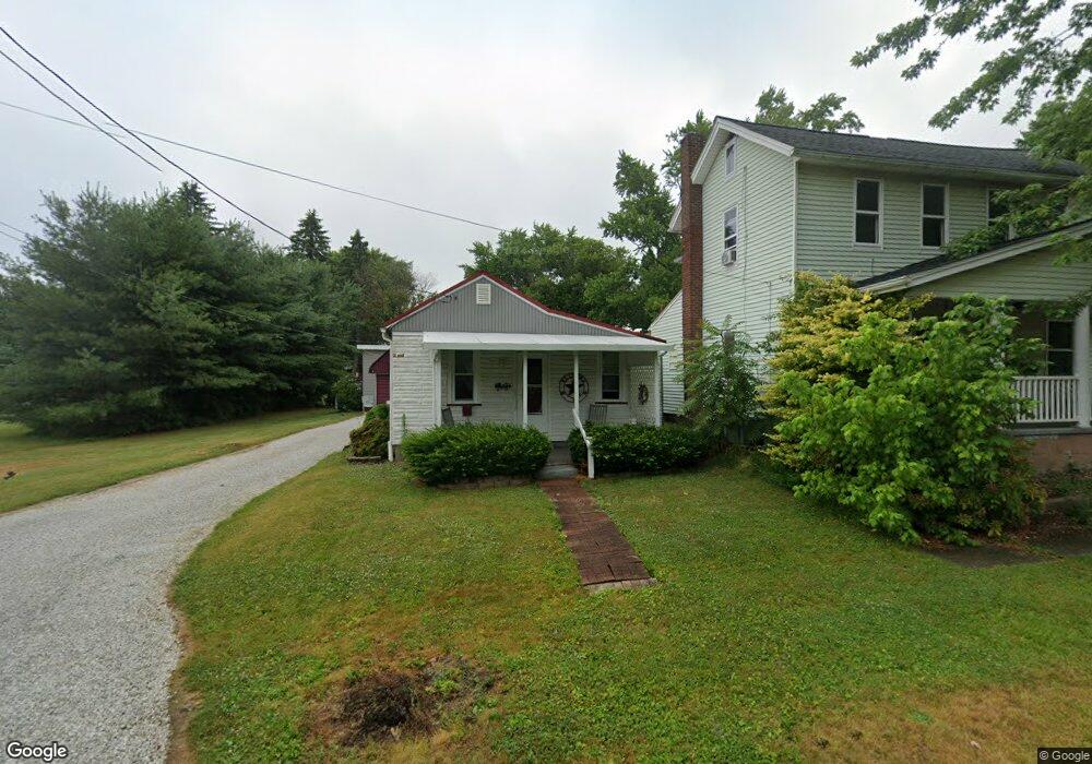
131 Walnut St E East Canton, OH 44730
Estimated Value: $74,844 - $91,000
2
Beds
1
Bath
726
Sq Ft
$113/Sq Ft
Est. Value
About This Home
This home is located at 131 Walnut St E, East Canton, OH 44730 and is currently estimated at $81,961, approximately $112 per square foot. 131 Walnut St E is a home located in Stark County with nearby schools including East Canton Elementary School, East Canton Middle School, and East Canton High School.
Ownership History
Date
Name
Owned For
Owner Type
Purchase Details
Closed on
Jul 29, 2025
Sold by
Stringer Marla and Stringer Norris W
Bought by
Nemitz Lisa
Current Estimated Value
Purchase Details
Closed on
Apr 30, 2009
Sold by
Sharp Marjorie M
Bought by
Wottle Jack and Wottle Patsy A
Home Financials for this Owner
Home Financials are based on the most recent Mortgage that was taken out on this home.
Original Mortgage
$28,000
Interest Rate
5.05%
Mortgage Type
Purchase Money Mortgage
Create a Home Valuation Report for This Property
The Home Valuation Report is an in-depth analysis detailing your home's value as well as a comparison with similar homes in the area
Home Values in the Area
Average Home Value in this Area
Purchase History
| Date | Buyer | Sale Price | Title Company |
|---|---|---|---|
| Nemitz Lisa | -- | None Listed On Document | |
| Wottle Jack | $35,000 | Attorney |
Source: Public Records
Mortgage History
| Date | Status | Borrower | Loan Amount |
|---|---|---|---|
| Previous Owner | Wottle Jack | $28,000 |
Source: Public Records
Tax History Compared to Growth
Tax History
| Year | Tax Paid | Tax Assessment Tax Assessment Total Assessment is a certain percentage of the fair market value that is determined by local assessors to be the total taxable value of land and additions on the property. | Land | Improvement |
|---|---|---|---|---|
| 2025 | -- | $17,930 | $5,150 | $12,780 |
| 2024 | -- | $17,930 | $5,150 | $12,780 |
| 2023 | $294 | $15,690 | $4,450 | $11,240 |
| 2022 | $300 | $15,690 | $4,450 | $11,240 |
| 2021 | $301 | $15,690 | $4,450 | $11,240 |
| 2020 | $228 | $13,480 | $3,990 | $9,490 |
| 2019 | $224 | $13,480 | $3,990 | $9,490 |
| 2018 | $222 | $13,480 | $3,990 | $9,490 |
| 2017 | $157 | $12,260 | $3,680 | $8,580 |
| 2016 | $137 | $11,770 | $3,680 | $8,090 |
| 2015 | $138 | $11,770 | $3,680 | $8,090 |
| 2014 | $60 | $9,870 | $3,080 | $6,790 |
| 2013 | $33 | $9,870 | $3,080 | $6,790 |
Source: Public Records
Map
Nearby Homes
- 223 Nassau St W
- 233 Nassau St W
- 225 - 227 Plum St N
- 711 Nassau St W
- 0 Lincoln St SE Unit 5157290
- 0 Lincoln St SE Unit 5157308
- 0 Lincoln St SE Unit 5157344
- 1527 Johns Ave SE
- 2260 Broadway Ave NE
- 2386 Broadway Ave NE
- 6416 15th St NE
- 2425 Miday Ave NE
- 4520 Georgetown Rd NE
- 6969 Georgetown St NE
- 2802 Trump Ave SE
- 1990 Belfort Ave
- 3025 Orchardview Dr SE
- 3153 Waynesburg Dr SE
- 0 Neimans Ave SE Unit 5149957
- 8225 Georgetown St
- 127 Walnut St E
- 220 Cedar St S
- 121 Walnut St E
- 212 Cedar St S
- 227 Cedar St S
- 112 Liberty St E
- 108 Liberty St E
- 100 Walnut St W
- 213 Wood St S
- 204 Cedar St S
- 109 Walnut St W
- 108 Walnut St W
- 120 Liberty St E
- 203 Cedar St S
- 113 Walnut St W
- 130 Liberty St E
- 112 Walnut St E
- 121 Walnut St W
- 112 Liberty St W
- 137 Liberty St E