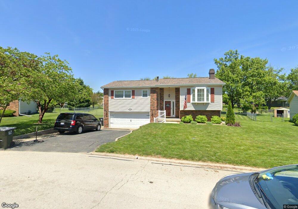
1310 Nolan Ct Mount Zion, IL 62549
Estimated Value: $180,000 - $217,000
3
Beds
2
Baths
1,737
Sq Ft
$112/Sq Ft
Est. Value
About This Home
This home is located at 1310 Nolan Ct, Mount Zion, IL 62549 and is currently estimated at $195,341, approximately $112 per square foot. 1310 Nolan Ct is a home located in Macon County with nearby schools including McGaughey Elementary School, Mt. Zion Elementary School, and Mt. Zion Intermediate School.
Ownership History
Date
Name
Owned For
Owner Type
Purchase Details
Closed on
Sep 21, 2006
Sold by
Sirva Relocation Credit Llc
Bought by
Chew Melanie
Current Estimated Value
Home Financials for this Owner
Home Financials are based on the most recent Mortgage that was taken out on this home.
Original Mortgage
$30,000
Interest Rate
6.25%
Mortgage Type
New Conventional
Purchase Details
Closed on
Sep 12, 2006
Sold by
Bakunas David M and Bakunas Kemberly S
Bought by
Sirva Relocation Credit Llc
Home Financials for this Owner
Home Financials are based on the most recent Mortgage that was taken out on this home.
Original Mortgage
$30,000
Interest Rate
6.25%
Mortgage Type
New Conventional
Purchase Details
Closed on
May 1, 2001
Create a Home Valuation Report for This Property
The Home Valuation Report is an in-depth analysis detailing your home's value as well as a comparison with similar homes in the area
Home Values in the Area
Average Home Value in this Area
Purchase History
| Date | Buyer | Sale Price | Title Company |
|---|---|---|---|
| Chew Melanie | $113,000 | None Available | |
| Sirva Relocation Credit Llc | $113,000 | None Available | |
| -- | $95,800 | -- |
Source: Public Records
Mortgage History
| Date | Status | Borrower | Loan Amount |
|---|---|---|---|
| Closed | Chew Melanie | $30,000 |
Source: Public Records
Tax History Compared to Growth
Tax History
| Year | Tax Paid | Tax Assessment Tax Assessment Total Assessment is a certain percentage of the fair market value that is determined by local assessors to be the total taxable value of land and additions on the property. | Land | Improvement |
|---|---|---|---|---|
| 2024 | $3,596 | $52,073 | $7,261 | $44,812 |
| 2023 | $3,465 | $48,431 | $6,753 | $41,678 |
| 2022 | $3,305 | $45,937 | $6,405 | $39,532 |
| 2021 | $3,195 | $43,035 | $6,000 | $37,035 |
| 2020 | $2,634 | $36,889 | $7,166 | $29,723 |
| 2019 | $2,634 | $36,889 | $7,166 | $29,723 |
| 2018 | $2,547 | $35,947 | $6,983 | $28,964 |
| 2017 | $2,508 | $35,256 | $6,849 | $28,407 |
| 2016 | $2,479 | $34,643 | $6,730 | $27,913 |
| 2015 | $2,395 | $34,300 | $6,663 | $27,637 |
| 2014 | $2,308 | $34,300 | $6,663 | $27,637 |
| 2013 | $2,335 | $34,300 | $6,663 | $27,637 |
Source: Public Records
Map
Nearby Homes
- 925 S Wildwood Dr
- 1610 Robin Ct
- 24 Buttonridge Place
- 860 W Wildwood Dr
- 735 Eric Ct
- 570 Fawn Ct
- 1820 Buckhead Ln
- 265 Carrington Ave
- 2125 Buckhead Ave
- 2110 Buckhead Ln
- 2130 Buckhead Ave
- 1935 Buckhead Ct
- 125 W Walnut St
- 2020 Buckhead Ln
- 2030 Buckhead Ln
- 3330 S Baltimore Ave
- 1440 N Alexander Dr
- 820 Kirk Dr
- 400 Maddox Dr
- 5301 Ricky Dr
- 1235 Nolan Ave
- 1320 Nolan Ct
- 1310 Westside Dr
- 1325 Brierwood Dr
- 1315 Nolan Ct
- 1330 Nolan Ct
- 1325 Nolan Ct
- 1225 Nolan Ave
- 1315 Brierwood Dr
- 1320 Westside Dr
- 1230 Westside Dr
- 1240 Westside Dr
- 1335 Brierwood Dr
- 1220 Westside Dr
- 1340 Nolan Ct
- 1215 Nolan Ave
- 1330 Westside Dr
- 1335 Nolan Ct
- 1140 Dee Lee Ln
- 1320 Brierwood Dr