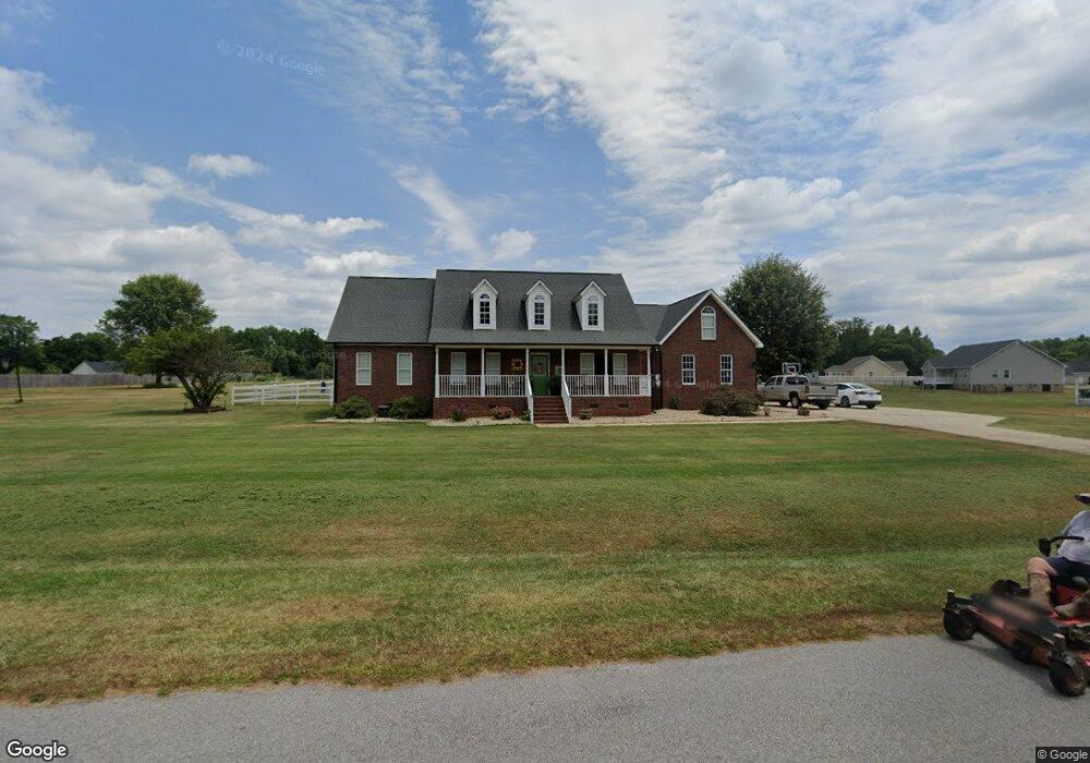
1311 Bryson Creek Rd Mc Connells, SC 29726
Estimated Value: $330,743 - $497,000
3
Beds
2
Baths
2,500
Sq Ft
$173/Sq Ft
Est. Value
About This Home
This home is located at 1311 Bryson Creek Rd, Mc Connells, SC 29726 and is currently estimated at $432,936, approximately $173 per square foot. 1311 Bryson Creek Rd is a home located in York County with nearby schools including Jefferson Elementary School, York Intermediate School, and York Middle School.
Ownership History
Date
Name
Owned For
Owner Type
Purchase Details
Closed on
Dec 22, 2010
Sold by
Wells Fargo Bank N A
Bought by
Mitchelson Linda
Current Estimated Value
Purchase Details
Closed on
Dec 21, 2010
Sold by
Wells Fargo Bank N A
Bought by
Wells Fargo Bank N A
Purchase Details
Closed on
Aug 1, 2010
Sold by
Clawson Janet M and Clawson Willie
Bought by
Wells Fargo Bank Na
Purchase Details
Closed on
May 19, 2006
Sold by
Clawson Willie
Bought by
Clawson Janet M
Purchase Details
Closed on
Dec 19, 2002
Sold by
Harshaw Peggy C
Bought by
Clawson Willie
Purchase Details
Closed on
Oct 22, 1999
Sold by
Bryson Creek Subdivision I
Bought by
Harshaw Peggy C
Create a Home Valuation Report for This Property
The Home Valuation Report is an in-depth analysis detailing your home's value as well as a comparison with similar homes in the area
Home Values in the Area
Average Home Value in this Area
Purchase History
| Date | Buyer | Sale Price | Title Company |
|---|---|---|---|
| Mitchelson Linda | $132,500 | -- | |
| Wells Fargo Bank N A | -- | -- | |
| Wells Fargo Bank Na | $130,798 | -- | |
| Clawson Janet M | -- | None Available | |
| Clawson Willie | $193,500 | -- | |
| Harshaw Peggy C | $16,000 | -- |
Source: Public Records
Tax History Compared to Growth
Tax History
| Year | Tax Paid | Tax Assessment Tax Assessment Total Assessment is a certain percentage of the fair market value that is determined by local assessors to be the total taxable value of land and additions on the property. | Land | Improvement |
|---|---|---|---|---|
| 2025 | $1,552 | $9,628 | $1,035 | $8,593 |
| 2024 | $1,297 | $8,372 | $835 | $7,537 |
| 2023 | $1,327 | $8,372 | $835 | $7,537 |
| 2022 | $1,340 | $8,372 | $835 | $7,537 |
| 2021 | -- | $8,372 | $835 | $7,537 |
| 2020 | $1,344 | $8,372 | $0 | $0 |
| 2019 | $1,219 | $7,280 | $0 | $0 |
| 2018 | $1,174 | $7,280 | $0 | $0 |
| 2017 | $1,112 | $7,280 | $0 | $0 |
| 2016 | $1,098 | $7,280 | $0 | $0 |
| 2014 | $1,057 | $7,280 | $1,000 | $6,280 |
| 2013 | $1,057 | $7,520 | $1,000 | $6,520 |
Source: Public Records
Map
Nearby Homes
- 1302 Bryson Creek Dr
- 1334 Bryson Creek Dr
- 1348 Bryson Creek Dr
- 615 Hawley Rd
- 1369 Mack Dr
- 211 Daves Rd
- 108 Daves Rd
- 1865 McConnells Hwy W
- 208 Daves Rd
- 1951 McConnells Hwy W
- 143 Flushing Dr
- 6.5 + - Ac Bookout Rd
- 2099 Cedar Rd
- 5072 Mobley Store Rd
- 5+/-AC Bookout Rd
- 6.5+/-AC Bookout Rd
- 6+/-AC Bookout Rd
- 1019 Perla Rd
- 5027 Mobley Store Rd
- 665 N Burris Rd
- 1307 Bryson Creek Dr
- 1307 Bryson Creek Dr
- 1307 Bryson Creek Dr Unit 22
- 1323 Bryson Creek Dr
- 1317 Bryson Creek Dr Unit 30
- 1323 Bryson Creek Dr
- 1303 Bryson Creek Dr
- 1314 Bryson Creek Dr
- 1314 Bryson Creek Rd
- 1314 Bryson Creek Rd Unit 4
- 1329 Bryson Creek Dr Unit 19
- 1310 Bryson Creek Rd
- 1318 Bryson Creek Dr Unit 5
- 1322 Bryson Creek Dr
- 1306 Bryson Creek Dr Unit 2
- 1306 Bryson Creek Dr
- 259 Church St
- 259 Church St Unit 25
- 1326 Bryson Creek Dr
- 1335 Bryson Creek Dr