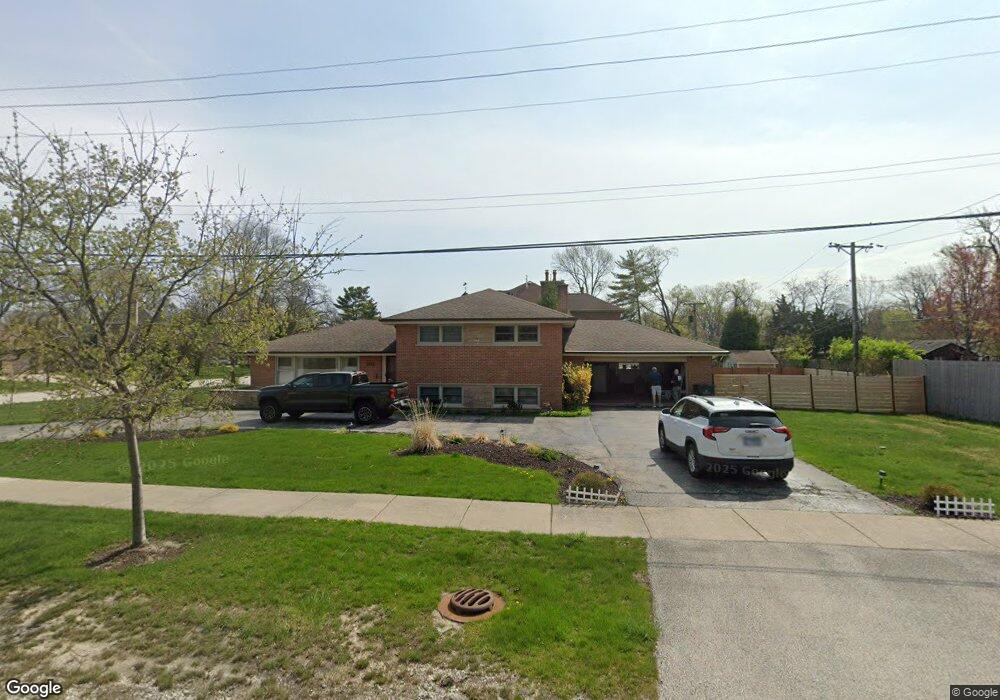
1311 Harms Rd Glenview, IL 60025
Estimated Value: $712,544 - $759,000
4
Beds
3
Baths
1,457
Sq Ft
$507/Sq Ft
Est. Value
About This Home
This home is located at 1311 Harms Rd, Glenview, IL 60025 and is currently estimated at $738,886, approximately $507 per square foot. 1311 Harms Rd is a home located in Cook County with nearby schools including Marie Murphy School, Avoca West Elementary School, and New Trier Township High School - Northfield.
Ownership History
Date
Name
Owned For
Owner Type
Purchase Details
Closed on
Jun 4, 2024
Sold by
Bozic Tom
Bought by
Tom Bozic Trust and Bozic
Current Estimated Value
Purchase Details
Closed on
Sep 8, 2023
Sold by
Annemarie Bozic Trust
Bought by
Bozic Tom
Purchase Details
Closed on
Sep 15, 2010
Sold by
Bozic Annemarie
Bought by
Bozic Annemarie and Annemarie Bozic Trust
Create a Home Valuation Report for This Property
The Home Valuation Report is an in-depth analysis detailing your home's value as well as a comparison with similar homes in the area
Home Values in the Area
Average Home Value in this Area
Purchase History
| Date | Buyer | Sale Price | Title Company |
|---|---|---|---|
| Tom Bozic Trust | -- | None Listed On Document | |
| Bozic Tom | -- | None Listed On Document | |
| Bozic Annemarie | -- | None Available |
Source: Public Records
Tax History Compared to Growth
Tax History
| Year | Tax Paid | Tax Assessment Tax Assessment Total Assessment is a certain percentage of the fair market value that is determined by local assessors to be the total taxable value of land and additions on the property. | Land | Improvement |
|---|---|---|---|---|
| 2024 | $8,548 | $44,974 | $17,408 | $27,566 |
| 2023 | $8,147 | $44,974 | $17,408 | $27,566 |
| 2022 | $8,147 | $44,974 | $17,408 | $27,566 |
| 2021 | $5,509 | $37,347 | $12,512 | $24,835 |
| 2020 | $5,003 | $37,347 | $12,512 | $24,835 |
| 2019 | $4,919 | $41,041 | $12,512 | $28,529 |
| 2018 | $5,242 | $36,181 | $10,336 | $25,845 |
| 2017 | $5,001 | $36,181 | $10,336 | $25,845 |
| 2016 | $5,436 | $36,181 | $10,336 | $25,845 |
| 2015 | $7,241 | $31,598 | $8,432 | $23,166 |
| 2014 | $6,101 | $31,598 | $8,432 | $23,166 |
| 2013 | $6,461 | $34,614 | $8,432 | $26,182 |
Source: Public Records
Map
Nearby Homes
- 1201 Harms Rd
- 228 Mark Dr
- 1115 Hunter Rd
- 4072 Bunker Ln
- 941 Harms Rd
- 1101 Juniper Terrace
- 1133 Manor Dr
- 3507 Greenwood Ave
- 341 Taft Ct
- 542 Laramie Ave
- 821 Harms Rd
- 1702 Del Ogier Dr
- 711 Becker Rd
- 737 Becker Rd
- 25 Wilmette Ave
- 828 Lavergne Ave
- 846 Wagner Rd
- 1019 Burton Terrace
- 639 Harms Rd
- 3227 Greenleaf Ave