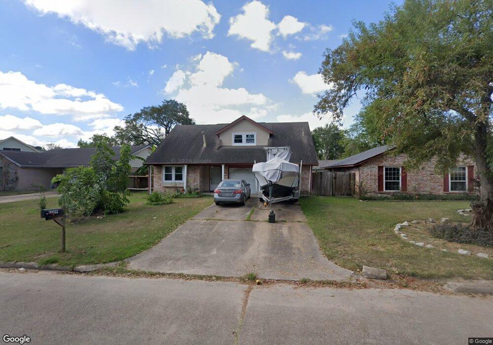
13119 Woodington Dr Houston, TX 77038
North Houston NeighborhoodEstimated Value: $208,965 - $239,000
4
Beds
3
Baths
1,581
Sq Ft
$142/Sq Ft
Est. Value
About This Home
This home is located at 13119 Woodington Dr, Houston, TX 77038 and is currently estimated at $224,491, approximately $141 per square foot. 13119 Woodington Dr is a home located in Harris County with nearby schools including Gloria B. Sammons Elementary School, Stovall School, and Dr. Viola K. Garcia Middle School.
Ownership History
Date
Name
Owned For
Owner Type
Purchase Details
Closed on
Sep 10, 1999
Sold by
Davis James E and Davis Cynthia B
Bought by
Sisoumphou Sangarloune and Sisoumphou Somphone
Current Estimated Value
Home Financials for this Owner
Home Financials are based on the most recent Mortgage that was taken out on this home.
Original Mortgage
$54,800
Interest Rate
7.9%
Create a Home Valuation Report for This Property
The Home Valuation Report is an in-depth analysis detailing your home's value as well as a comparison with similar homes in the area
Home Values in the Area
Average Home Value in this Area
Purchase History
| Date | Buyer | Sale Price | Title Company |
|---|---|---|---|
| Sisoumphou Sangarloune | -- | Fidelity National Title |
Source: Public Records
Mortgage History
| Date | Status | Borrower | Loan Amount |
|---|---|---|---|
| Closed | Sisoumphou Sangarloune | $54,800 |
Source: Public Records
Tax History Compared to Growth
Tax History
| Year | Tax Paid | Tax Assessment Tax Assessment Total Assessment is a certain percentage of the fair market value that is determined by local assessors to be the total taxable value of land and additions on the property. | Land | Improvement |
|---|---|---|---|---|
| 2025 | $3,282 | $176,668 | $36,373 | $140,295 |
| 2024 | $3,282 | $172,686 | $36,373 | $136,313 |
| 2023 | $3,282 | $172,686 | $36,373 | $136,313 |
| 2022 | $4,060 | $156,580 | $36,373 | $120,207 |
| 2021 | $3,824 | $134,149 | $21,824 | $112,325 |
| 2020 | $3,909 | $134,149 | $21,824 | $112,325 |
| 2019 | $3,685 | $117,600 | $21,824 | $95,776 |
| 2018 | $3,426 | $111,182 | $21,824 | $89,358 |
| 2017 | $1,899 | $0 | $0 | $0 |
| 2016 | $2,264 | $90,683 | $21,824 | $68,859 |
| 2015 | $1,653 | $93,217 | $21,824 | $71,393 |
| 2014 | $1,653 | $60,829 | $14,549 | $46,280 |
Source: Public Records
Map
Nearby Homes
- 2614 Lemonwood Ln
- 2203 Chalet Rd
- 2115 Havencrest Dr
- 2530 Woodtown Dr
- 2719 Magnolia Hill Trail
- 2811 Oakland Brook St
- 0 W Mt Houston Rd Unit 90464120
- 2831 Oakland Brook St
- 00 Fallbrook Dr
- 2835 Oakland Brook St
- 2838 Packard Elm St
- 12718 Sai Baba Dr
- 1327 Fallbrook Dr
- 1219 Pilot Point Dr
- 1506 Wilshire Park Dr
- Whitetail Plan at Forestwood
- Kitson Plan at Forestwood
- Pinehollow Plan at Forestwood
- 12530 Wild Strawberry Rd
- Idlewood Plan at Forestwood
- 13121 Woodington Dr
- 13123 Woodington Dr
- 13115 Woodington Dr
- 13127 Woodington Dr
- 13111 Woodington Dr
- 13114 Berkwood Ct
- 13120 Woodington Dr
- 13110 Berkwood Ct
- 13116 Woodington Dr
- 13124 Woodington Dr
- 13107 Woodington Dr
- 13118 Berkwood Ct
- 13131 Woodington Dr
- 13112 Woodington Dr
- 13118 Woodington Dr
- 13122 Woodington Dr
- 13114 Woodington Dr
- 13106 Berkwood Ct
- 13126 Woodington Dr
- 13110 Woodington Dr