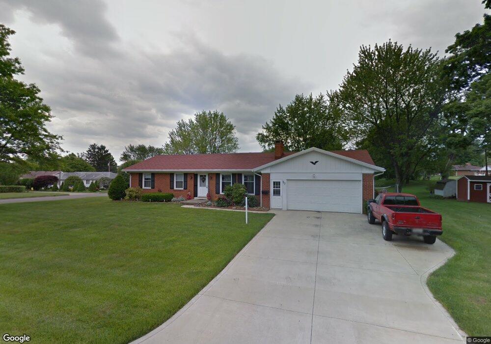
1312 Paul Blvd Mansfield, OH 44907
Estimated Value: $199,000 - $236,000
3
Beds
2
Baths
1,360
Sq Ft
$157/Sq Ft
Est. Value
About This Home
This home is located at 1312 Paul Blvd, Mansfield, OH 44907 and is currently estimated at $212,905, approximately $156 per square foot. 1312 Paul Blvd is a home located in Richland County with nearby schools including Mansfield Christian School, Discovery School, and Mansfield Seventh-day Adventist School.
Ownership History
Date
Name
Owned For
Owner Type
Purchase Details
Closed on
Sep 2, 2015
Sold by
Huffman Leslie and Huffman Gloria W
Bought by
Huffman Leslie and Huffman Gloria W
Current Estimated Value
Purchase Details
Closed on
May 21, 1997
Sold by
Pamer Arthur E
Bought by
Huffman Leslie and Huffman Gloria W
Home Financials for this Owner
Home Financials are based on the most recent Mortgage that was taken out on this home.
Original Mortgage
$93,600
Interest Rate
8.24%
Mortgage Type
New Conventional
Purchase Details
Closed on
Feb 1, 1993
Sold by
Richard George A
Bought by
Richard Beverly J
Create a Home Valuation Report for This Property
The Home Valuation Report is an in-depth analysis detailing your home's value as well as a comparison with similar homes in the area
Home Values in the Area
Average Home Value in this Area
Purchase History
| Date | Buyer | Sale Price | Title Company |
|---|---|---|---|
| Huffman Leslie | -- | Attorney | |
| Huffman Leslie | $117,000 | -- | |
| Richard Beverly J | -- | -- |
Source: Public Records
Mortgage History
| Date | Status | Borrower | Loan Amount |
|---|---|---|---|
| Previous Owner | Huffman Leslie | $93,600 |
Source: Public Records
Tax History Compared to Growth
Tax History
| Year | Tax Paid | Tax Assessment Tax Assessment Total Assessment is a certain percentage of the fair market value that is determined by local assessors to be the total taxable value of land and additions on the property. | Land | Improvement |
|---|---|---|---|---|
| 2024 | $1,860 | $49,530 | $10,500 | $39,030 |
| 2023 | $1,860 | $49,530 | $10,500 | $39,030 |
| 2022 | $1,498 | $35,570 | $8,340 | $27,230 |
| 2021 | $1,509 | $35,570 | $8,340 | $27,230 |
| 2020 | $1,543 | $35,570 | $8,340 | $27,230 |
| 2019 | $1,364 | $30,150 | $7,070 | $23,080 |
| 2018 | $1,346 | $30,150 | $7,070 | $23,080 |
| 2017 | $1,310 | $30,150 | $7,070 | $23,080 |
| 2016 | $2,018 | $40,720 | $9,100 | $31,620 |
| 2015 | $1,927 | $40,720 | $9,100 | $31,620 |
| 2014 | $1,902 | $40,720 | $9,100 | $31,620 |
| 2012 | $773 | $42,860 | $9,580 | $33,280 |
Source: Public Records
Map
Nearby Homes
- 478 Clearview Rd
- 646 Kennedy Dr
- 0 Lexington Ave Unit 224009661
- 484 Beechwood Dr
- 0 U S Highway 42
- 501 Clifton Blvd
- 1125 Larchwood Rd
- 1156 Yorkwood Rd
- 654 Courtwright Blvd
- 1179 Burkwood Rd
- 1689 Middle Bellville Rd
- 1009 Woodhill Rd
- 1702 Middle Bellville Rd
- 823 Red Oak Trail Unit 2
- 823 1 2 Red Oak Trail
- 823 1/2 Red Oak Trail
- 1011 Princeton Trace
- 1690 Riva Ridge Dr Unit 1690
- 0 Rippling Brook Dr
- 1696 Riva Ridge Dr
- 530 Clearview Rd
- 487 Birchlawn Blvd
- 540 Clearview Rd Unit 42
- 540-542 Clearview Rd
- 1327 Paul Blvd
- 495 Birchlawn Blvd
- 473 Birchlawn Blvd
- 1340 Paul Blvd
- 1315 Paul Blvd
- 503 Birchlawn Blvd Unit 511
- 0 Birchlawn Blvd
- 1263 Knapp Rd
- 1252 Knapp Rd
- 465 Birchlawn Blvd
- 1337 Paul Blvd
- 554 Clearview Rd
- 519 Birchlawn Blvd
- 471 Clearview Rd
- 466 Birchlawn Blvd
- 1262 Knapp Rd