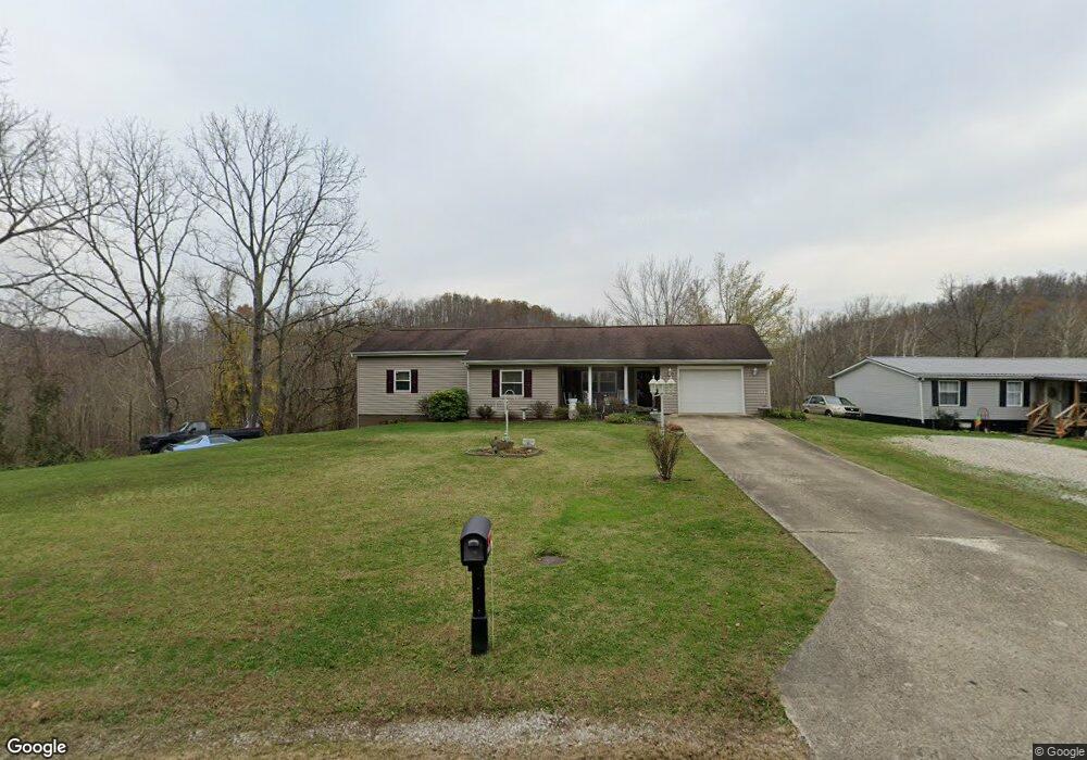
13124 State Route 243 Chesapeake, OH 45619
Estimated Value: $151,000 - $202,000
2
Beds
1
Bath
1,368
Sq Ft
$120/Sq Ft
Est. Value
About This Home
This home is located at 13124 State Route 243, Chesapeake, OH 45619 and is currently estimated at $164,518, approximately $120 per square foot. 13124 State Route 243 is a home located in Lawrence County with nearby schools including Chesapeake Elementary School, Chesapeake Middle School, and Chesapeake High School.
Ownership History
Date
Name
Owned For
Owner Type
Purchase Details
Closed on
May 14, 2018
Sold by
Hankins Vicki V
Bought by
Renaye-Johnson Heather and Johnson Brandon
Current Estimated Value
Purchase Details
Closed on
May 14, 2003
Sold by
Ward Thomas E and Ward Vicki D
Bought by
Hankins Ronald R and Hankins Vick
Purchase Details
Closed on
Apr 22, 2003
Sold by
Ward Sherrill E and Ward Louis
Bought by
Ward, Sherrill E. Life Es
Purchase Details
Closed on
Apr 9, 1998
Sold by
Ward Sherrill E and Ward Louis
Bought by
Ward Sherrill E and Ward Louis
Create a Home Valuation Report for This Property
The Home Valuation Report is an in-depth analysis detailing your home's value as well as a comparison with similar homes in the area
Home Values in the Area
Average Home Value in this Area
Purchase History
| Date | Buyer | Sale Price | Title Company |
|---|---|---|---|
| Renaye-Johnson Heather | -- | -- | |
| Hankins Ronald R | $50,000 | -- | |
| Ward, Sherrill E. Life Es | -- | -- | |
| Ward Sherrill E | -- | -- |
Source: Public Records
Tax History Compared to Growth
Tax History
| Year | Tax Paid | Tax Assessment Tax Assessment Total Assessment is a certain percentage of the fair market value that is determined by local assessors to be the total taxable value of land and additions on the property. | Land | Improvement |
|---|---|---|---|---|
| 2024 | -- | $32,560 | $7,000 | $25,560 |
| 2023 | $936 | $32,560 | $7,000 | $25,560 |
| 2022 | $934 | $32,560 | $7,000 | $25,560 |
| 2021 | $894 | $29,920 | $6,600 | $23,320 |
| 2020 | $911 | $29,970 | $6,600 | $23,370 |
| 2019 | $910 | $29,970 | $6,600 | $23,370 |
| 2018 | $894 | $29,970 | $6,600 | $23,370 |
| 2017 | $910 | $30,500 | $7,130 | $23,370 |
| 2016 | $844 | $30,500 | $7,130 | $23,370 |
| 2015 | $780 | $27,940 | $7,140 | $20,800 |
| 2014 | $780 | $27,940 | $7,140 | $20,800 |
| 2013 | $780 | $27,940 | $7,140 | $20,800 |
Source: Public Records
Map
Nearby Homes
- 275 Township Road 118
- 253 Township Road 1357
- 14 Township Road 1356
- 135 Township Road 85 E
- 152 Township Road 1483
- 3493 County Road 31
- 3171 County Road 31
- 983 County Road 104
- 101 Township Road 1119
- 1666 County Road 31
- 81 Township Road 158
- 1334 McKinney Creek-Hesson Hollow Rd N
- 1334 Township Road 214th N
- 66 Township Road 1523
- 301 Township Road 158
- 101 Township Road 1199
- 30 Township Road 1482
- 0 County Road 123
- 63 Township Road 1197
- 15 Private Dr
- 13013 State Route 243
- 13022 State Route 243
- 15961 Ohio 243
- 13271 State Route 243
- 23 Vista View Estates
- CO RD 15 Buffalo Creek
- 1714 Heatherbrook
- 550 Watts Ridge Unit 550 Private Drive 34
- 0 Bridge Buffalo Creek Rd
- 222 Twp Rd 100
- 0 Robinson Rd Unit 158922
- 0 Pvt Dr 100 Lot 3 Unit 165634
- 0 Pvt Drive 100 Unit 165595
- 51 Township Rd 1942
- 12935 State Route 243
- 12958 State Route 243
- 12958 Ohio 243
- 12867 State Route 243
- 140 County Road 36
- 13273 State Route 243