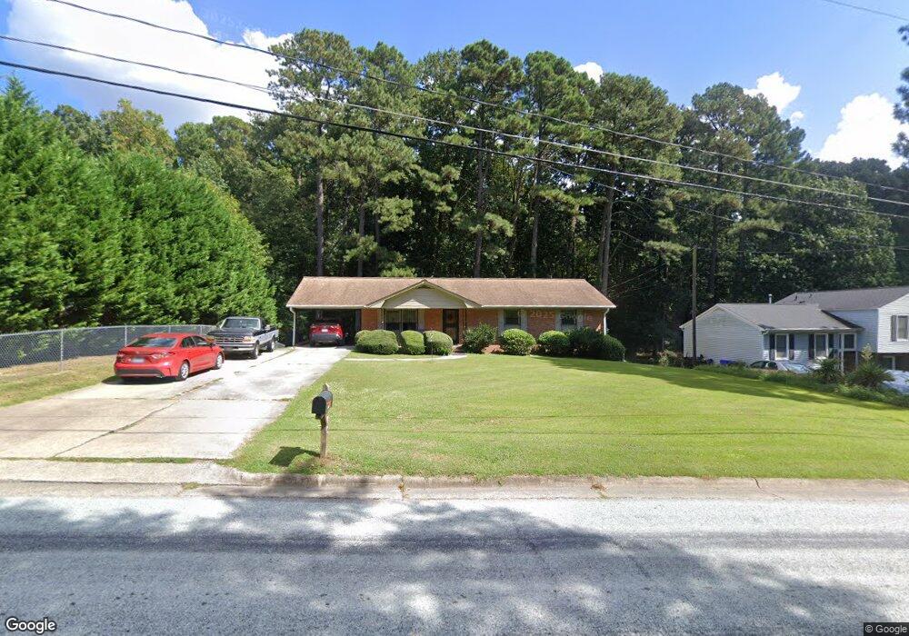
1313 Clinton Rd Durham, NC 27703
South Durham NeighborhoodEstimated Value: $328,000 - $350,000
3
Beds
2
Baths
1,911
Sq Ft
$178/Sq Ft
Est. Value
About This Home
This home is located at 1313 Clinton Rd, Durham, NC 27703 and is currently estimated at $340,128, approximately $177 per square foot. 1313 Clinton Rd is a home located in Durham County with nearby schools including R.N. Harris Elementary School, James E. Shepard Middle School, and Hillside High School.
Ownership History
Date
Name
Owned For
Owner Type
Purchase Details
Closed on
Jan 6, 2015
Sold by
Mcghee Martha
Bought by
Goodman Harry and Goodman Ingrid Renee
Current Estimated Value
Home Financials for this Owner
Home Financials are based on the most recent Mortgage that was taken out on this home.
Original Mortgage
$3,682
Outstanding Balance
$2,807
Interest Rate
4.03%
Mortgage Type
New Conventional
Estimated Equity
$337,321
Create a Home Valuation Report for This Property
The Home Valuation Report is an in-depth analysis detailing your home's value as well as a comparison with similar homes in the area
Home Values in the Area
Average Home Value in this Area
Purchase History
| Date | Buyer | Sale Price | Title Company |
|---|---|---|---|
| Goodman Harry | $125,000 | None Available |
Source: Public Records
Mortgage History
| Date | Status | Borrower | Loan Amount |
|---|---|---|---|
| Open | Goodman Harry | $3,682 |
Source: Public Records
Tax History
| Year | Tax Paid | Tax Assessment Tax Assessment Total Assessment is a certain percentage of the fair market value that is determined by local assessors to be the total taxable value of land and additions on the property. | Land | Improvement |
|---|---|---|---|---|
| 2025 | $3,228 | $325,661 | $129,200 | $196,461 |
| 2024 | $2,411 | $172,831 | $27,200 | $145,631 |
| 2023 | $2,264 | $172,831 | $27,200 | $145,631 |
| 2022 | $2,212 | $172,831 | $27,200 | $145,631 |
| 2021 | $2,202 | $172,831 | $27,200 | $145,631 |
| 2020 | $2,150 | $172,831 | $27,200 | $145,631 |
| 2019 | $2,150 | $172,831 | $27,200 | $145,631 |
| 2018 | $1,670 | $123,084 | $25,500 | $97,584 |
| 2017 | $1,657 | $123,084 | $25,500 | $97,584 |
| 2016 | $1,601 | $123,084 | $25,500 | $97,584 |
| 2015 | $1,714 | $123,810 | $25,303 | $98,507 |
| 2014 | $643 | $123,810 | $25,303 | $98,507 |
Source: Public Records
Map
Nearby Homes
- 2002 Strickland Oak Way
- 3224 Opal Dr
- 3216 Opal Dr
- 3214 Opal Dr
- 3212 Opal Dr
- 3210 Opal Dr
- 1412 Scholar Dr
- 17 Eddy Trail
- 1172 Pate Farm Ln
- 3004 Cypress Lagoon Ct
- 3112 Star Gazing Ln
- 1202 Ellis Rd
- 1206 Ellis Rd
- 3305 Delmar Dr
- 3303 Delmar Dr
- 1905 Edgerton Dr
- 905 Lippincott Rd
- 1610 Stone Rd
- 229 Zante Currant Rd
- 1035 Fitchie Place
- 1317 Clinton Rd
- 1305 Clinton Rd
- 1321 Clinton Rd
- 1327 Clinton Rd
- 1327 Clinton Rd Unit 1
- 1312 Clinton Rd
- 1316 Clinton Rd
- 1306 Clinton Rd
- 1301 Clinton Rd
- 1304 Clinton Rd
- 1302 Clinton Rd
- 1324 Clinton Rd
- 1309 Theodore Ln
- 1223 Clinton Rd
- 1311 Theodore Ln
- 1328 Clinton Rd
- 2304 Jane Ln
- 1224 Clinton Rd
- 1219 Clinton Rd
- 2505 Jane Ct
Your Personal Tour Guide
Ask me questions while you tour the home.