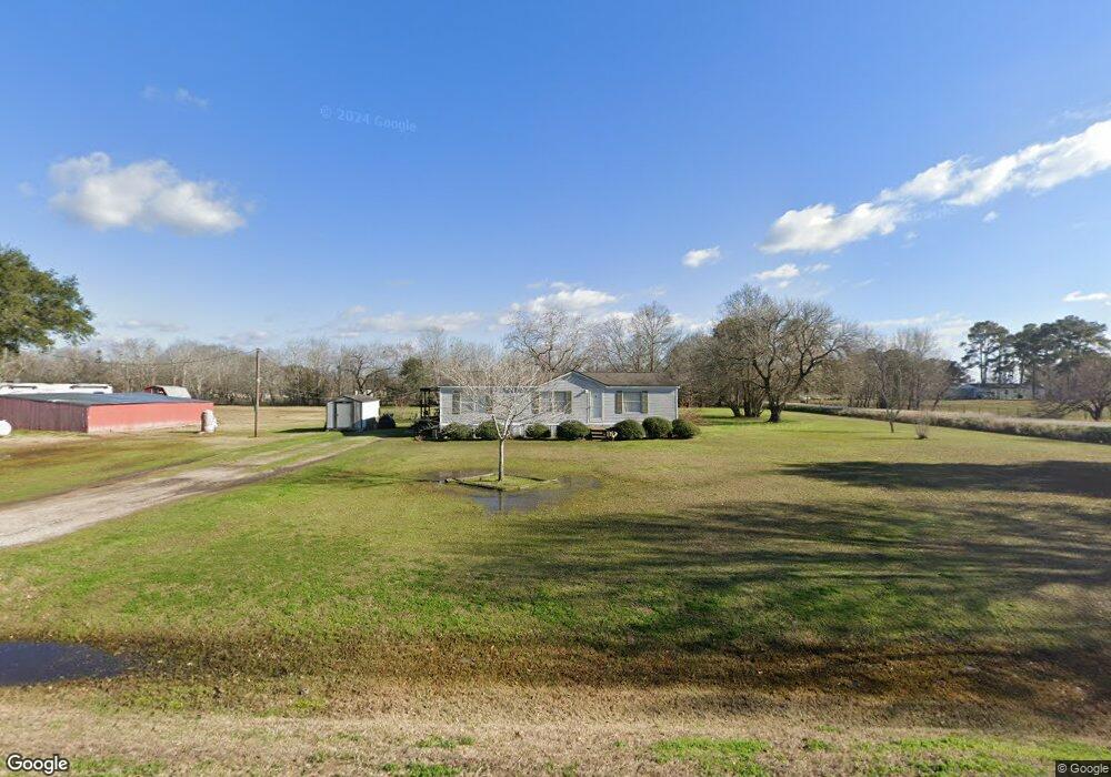
13135 Roesler Rd Needville, TX 77461
Estimated Value: $226,000 - $330,000
--
Bed
--
Bath
1,344
Sq Ft
$197/Sq Ft
Est. Value
About This Home
This home is located at 13135 Roesler Rd, Needville, TX 77461 and is currently estimated at $265,418, approximately $197 per square foot. 13135 Roesler Rd is a home with nearby schools including Needville Elementary School, Needville Junior High School, and Needville Middle School.
Ownership History
Date
Name
Owned For
Owner Type
Purchase Details
Closed on
Nov 15, 2024
Sold by
Walshak Joyce
Bought by
Craig Steven and Kerley-Craig Jennifer Marie
Current Estimated Value
Purchase Details
Closed on
Aug 22, 1996
Sold by
Denton Lilli Collins
Bought by
Walshak Joyce
Home Financials for this Owner
Home Financials are based on the most recent Mortgage that was taken out on this home.
Original Mortgage
$8,000
Interest Rate
8.42%
Create a Home Valuation Report for This Property
The Home Valuation Report is an in-depth analysis detailing your home's value as well as a comparison with similar homes in the area
Home Values in the Area
Average Home Value in this Area
Purchase History
| Date | Buyer | Sale Price | Title Company |
|---|---|---|---|
| Craig Steven | -- | None Listed On Document | |
| Craig Steven | -- | None Listed On Document | |
| Walshak Joyce | -- | -- |
Source: Public Records
Mortgage History
| Date | Status | Borrower | Loan Amount |
|---|---|---|---|
| Previous Owner | Walshak Joyce | $8,000 |
Source: Public Records
Tax History Compared to Growth
Tax History
| Year | Tax Paid | Tax Assessment Tax Assessment Total Assessment is a certain percentage of the fair market value that is determined by local assessors to be the total taxable value of land and additions on the property. | Land | Improvement |
|---|---|---|---|---|
| 2025 | $895 | $191,799 | $112,009 | $79,790 |
| 2024 | $895 | $117,830 | $38,460 | $79,370 |
| 2023 | $705 | $107,118 | $34,908 | $72,210 |
| 2022 | $1,317 | $97,380 | $0 | $100,010 |
| 2021 | $1,678 | $88,530 | $43,330 | $45,200 |
| 2020 | $1,627 | $80,480 | $43,330 | $37,150 |
| 2019 | $1,571 | $73,160 | $43,330 | $29,830 |
| 2018 | $1,426 | $66,510 | $42,920 | $23,590 |
| 2017 | $1,301 | $60,460 | $27,120 | $33,340 |
| 2016 | $1,182 | $54,960 | $24,100 | $30,860 |
| 2015 | $652 | $49,960 | $24,420 | $25,540 |
| 2014 | $724 | $45,420 | $24,420 | $21,000 |
Source: Public Records
Map
Nearby Homes
- 14935 Highway 36
- 14624 Dove Ln
- 0 Colony Rd
- 14238 Hay Meadow Ln
- 14234 Hay Meadow Ln
- 14218 Hay Meadow Ln
- 14214 Hay Meadow Ln
- 14235 Hay Meadow Ln
- 14231 Hay Meadow Ln
- 14222 Hay Meadow Ln
- 14239 Hay Meadow Ln
- 14227 Hay Meadow Ln
- 14226 Hay Meadow Ln
- 14230 Hay Meadow Ln
- 14218 Golden Wheat Ln
- 10853 Padon Rd
- Creede Plan at Harvest Pointe
- San Marcos Plan at Harvest Pointe
- Aquila Plan at Harvest Pointe
- Boise Plan at Harvest Pointe
- 13105 Roesler Rd
- 13036 Fm 442 Rd
- 13102 Fm 442 Rd
- 13014 Roesler Rd
- 13007 Roesler Rd
- 15420 Highway 36
- 13214 Fm 442 Rd
- 15308 Dipple Lehmann Rd
- 00 Dippel Lehmann Rd
- 15322 Highway 36
- 15322 Highway 36
- 15330 Highway 36
- 15222 Dipple Lehmann Rd
- 13139 Fm 442 Rd
- 0 Dipple-Lehman Rd Unit 45522131
- 0 Dipple-Lehman Rd Unit 1876627
- 0 Dipple-Lehman Rd
- 13213 Fm 442 Rd
- 15518 Highway 36
- 13213 Kanak St