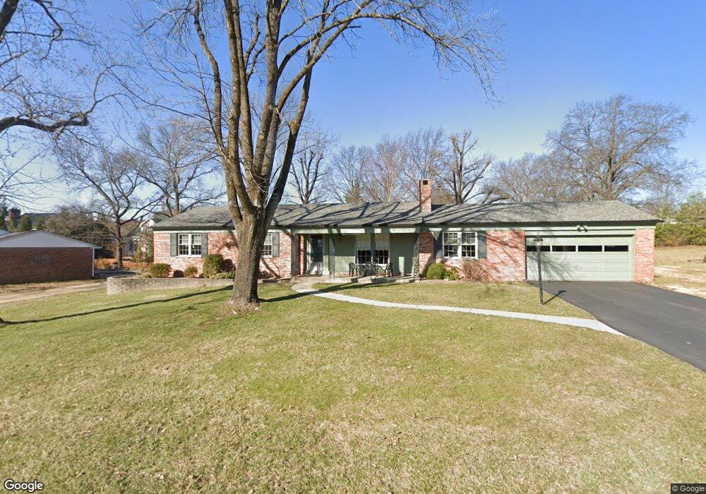
1315 Christine Ave Saint Louis, MO 63131
Estimated Value: $514,000 - $608,000
3
Beds
3
Baths
1,735
Sq Ft
$325/Sq Ft
Est. Value
About This Home
This home is located at 1315 Christine Ave, Saint Louis, MO 63131 and is currently estimated at $563,379, approximately $324 per square foot. 1315 Christine Ave is a home located in St. Louis County with nearby schools including Westchester Elementary School, North Kirkwood Middle School, and Kirkwood Senior High School.
Ownership History
Date
Name
Owned For
Owner Type
Purchase Details
Closed on
Jul 10, 1998
Sold by
Hensel Marvin A and Hensel Bernice P
Bought by
Hensel Bernice P and Hensel Marvin A
Current Estimated Value
Purchase Details
Closed on
Jun 17, 1998
Sold by
Hensel Marvin A and Hensel Bernice P
Bought by
Hensel Marvin A and Hensel Bernice P
Create a Home Valuation Report for This Property
The Home Valuation Report is an in-depth analysis detailing your home's value as well as a comparison with similar homes in the area
Home Values in the Area
Average Home Value in this Area
Purchase History
| Date | Buyer | Sale Price | Title Company |
|---|---|---|---|
| Hensel Bernice P | -- | -- | |
| Hensel Marvin A | -- | -- |
Source: Public Records
Tax History Compared to Growth
Tax History
| Year | Tax Paid | Tax Assessment Tax Assessment Total Assessment is a certain percentage of the fair market value that is determined by local assessors to be the total taxable value of land and additions on the property. | Land | Improvement |
|---|---|---|---|---|
| 2025 | $4,757 | $94,600 | $70,620 | $23,980 |
| 2024 | $4,757 | $82,120 | $53,030 | $29,090 |
| 2023 | $4,683 | $82,120 | $53,030 | $29,090 |
| 2022 | $4,630 | $75,680 | $53,030 | $22,650 |
| 2021 | $4,581 | $75,680 | $53,030 | $22,650 |
| 2020 | $4,418 | $70,160 | $48,940 | $21,220 |
| 2019 | $4,424 | $70,160 | $48,940 | $21,220 |
| 2018 | $4,071 | $57,910 | $27,280 | $30,630 |
| 2017 | $4,082 | $57,910 | $27,280 | $30,630 |
| 2016 | $3,736 | $53,650 | $23,480 | $30,170 |
| 2015 | $3,740 | $53,650 | $23,480 | $30,170 |
| 2014 | $3,496 | $48,990 | $10,740 | $38,250 |
Source: Public Records
Map
Nearby Homes
- 1090 Kinstern Dr
- 1126 Bopp Rd
- 1029 Kinstern Dr
- 8 Briarbrook Trail
- 918 N Ballas Rd
- 11913 Lillian Ave
- 11909 Lillian Ave
- 12006 Montour Dr
- 1345 Woodgate Dr
- 12224 TBB Roger Ln
- 811 Cherry St
- 12439 Springdale Ln Unit TBB
- 723 Oak Valley Dr
- 1728 Folkstone Dr
- 1741 Pine Hill Dr
- 1001 Dovergate Dr
- 1710 Lynkirk Ln
- The Hawthorne Plan at Ballas Ridge
- The Roclare II Plan at Ballas Ridge
- The Westchester IV Plan at Ballas Ridge
- 1323 Christine Ave
- 1305 Christine Ave
- 1322 Bansbach Rd
- 1318 Christine Ave
- 1328 Bansbach Rd
- 1312 Bansbach Rd
- 1331 Christine Ave
- 1326 Christine Ave
- 1301 Christine Ave
- 1308 Bansbach Rd
- 1334 Christine Ave
- 1300 Christine Ave
- 1340 Bansbach Rd
- 1304 Christine Ave
- 13000 Deutschmann Ln
- 1304 Bansbach Rd
- 12100 Georgian Trail
- 12007 Sandalwood Ct
- 12006 Sandalwood Ct
- 6 Woodbridge Park Rd