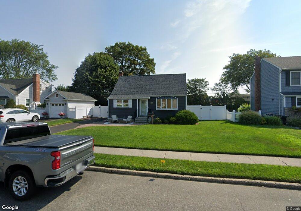
1315 Darby Rd W Wantagh, NY 11793
Estimated Value: $585,000 - $664,508
--
Bed
1
Bath
1,112
Sq Ft
$562/Sq Ft
Est. Value
About This Home
This home is located at 1315 Darby Rd W, Wantagh, NY 11793 and is currently estimated at $624,754, approximately $561 per square foot. 1315 Darby Rd W is a home located in Nassau County with nearby schools including Wantagh Middle School, Wantagh Senior High School, and Maplewood School.
Ownership History
Date
Name
Owned For
Owner Type
Purchase Details
Closed on
Apr 24, 2023
Sold by
Poggi Joseph and Poggi Jay
Bought by
Brooks Mark A and Brooks Karen
Current Estimated Value
Home Financials for this Owner
Home Financials are based on the most recent Mortgage that was taken out on this home.
Original Mortgage
$503,500
Outstanding Balance
$489,507
Interest Rate
6.6%
Mortgage Type
New Conventional
Estimated Equity
$135,247
Purchase Details
Closed on
Apr 19, 2018
Sold by
Poggi Pearl R
Bought by
Poggi Joseph and Poggi Jay
Create a Home Valuation Report for This Property
The Home Valuation Report is an in-depth analysis detailing your home's value as well as a comparison with similar homes in the area
Home Values in the Area
Average Home Value in this Area
Purchase History
| Date | Buyer | Sale Price | Title Company |
|---|---|---|---|
| Brooks Mark A | $530,000 | Your Title Experts | |
| Poggi Joseph | -- | -- |
Source: Public Records
Mortgage History
| Date | Status | Borrower | Loan Amount |
|---|---|---|---|
| Open | Brooks Mark A | $503,500 |
Source: Public Records
Tax History Compared to Growth
Tax History
| Year | Tax Paid | Tax Assessment Tax Assessment Total Assessment is a certain percentage of the fair market value that is determined by local assessors to be the total taxable value of land and additions on the property. | Land | Improvement |
|---|---|---|---|---|
| 2025 | $12,063 | $416 | $210 | $206 |
| 2024 | $3,486 | $504 | $254 | $250 |
| 2023 | $10,056 | $504 | $254 | $250 |
| 2022 | $10,056 | $504 | $254 | $250 |
| 2021 | $13,220 | $488 | $246 | $242 |
| 2020 | $9,431 | $647 | $614 | $33 |
| 2019 | $9,231 | $647 | $501 | $146 |
| 2018 | $9,231 | $793 | $0 | $0 |
| 2017 | $5,685 | $793 | $614 | $179 |
| 2016 | $9,147 | $793 | $614 | $179 |
| 2015 | $3,042 | $793 | $614 | $179 |
| 2014 | $3,042 | $793 | $614 | $179 |
| 2013 | $2,841 | $793 | $614 | $179 |
Source: Public Records
Map
Nearby Homes
- 1243 Peapond Rd
- 2889 Anderson St
- 1200 Roger Rd
- 2794 Janet Ave
- 1497 Carroll St
- 1483 Crown St
- 1253 Raymond Rd
- 84 Stanford Ct
- 236 Duckpond Dr S
- 1532 Peapond Rd
- 1427 Bellmore Rd
- 985 Douglas Ave
- 2960 Morgan Dr
- 2800 Pacific St
- 930 W Shelley Rd
- 1582 Little Neck Ave
- 2768 Wallace Ave
- 3356 Carrollton Ave
- 106 Soifer Ave
- 1600 Irving Ct
- 1321 Darby Rd W
- 1309 Darby Rd W
- 1316 Darby Rd E
- 1327 Darby Rd W
- 1310 Darby Rd E
- 1303 Darby Rd W
- 1322 Darby Rd E
- 1304 Darby Rd E
- 1320 Darby Rd W
- 1314 Darby Rd W
- 1328 Darby Rd E
- 1298 Darby Rd E
- 1326 Darby Rd W
- 1335 Darby Rd W
- 1308 Darby Rd W
- 1293 Darby Rd W
- 1332 Darby Rd W
- 1294 Darby Rd E
- 1298 Darby Rd W
- 1317 Darby Rd E