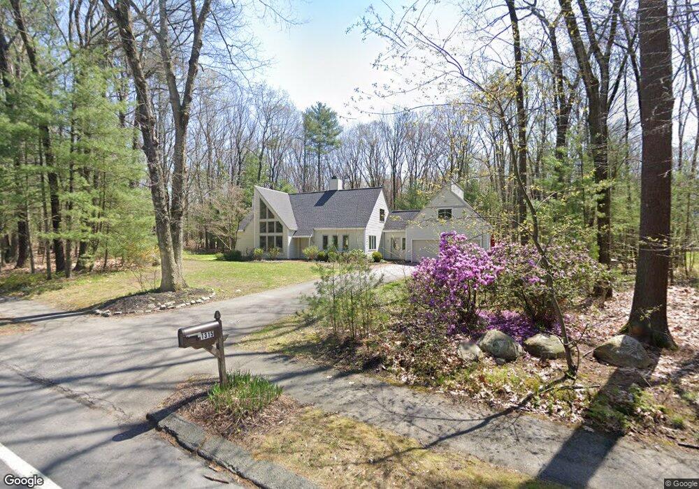
1315 Old Marlboro Rd Concord, MA 01742
Estimated Value: $1,531,000 - $1,743,000
3
Beds
2
Baths
3,180
Sq Ft
$507/Sq Ft
Est. Value
About This Home
This home is located at 1315 Old Marlboro Rd, Concord, MA 01742 and is currently estimated at $1,613,603, approximately $507 per square foot. 1315 Old Marlboro Rd is a home located in Middlesex County with nearby schools including Willard School, Concord Middle School, and Willow Hill School.
Ownership History
Date
Name
Owned For
Owner Type
Purchase Details
Closed on
Jun 28, 2022
Sold by
Wengrovitz Michael S and Wengrovitz Deborah O
Bought by
Wengrovitz Michael S and Wengrovitz Deborah O
Current Estimated Value
Purchase Details
Closed on
Jun 26, 1992
Sold by
Wennemer Manfred and Wennemer Rosa M
Bought by
Wengrovitz Michael S and Wengrovitz Deborah
Purchase Details
Closed on
Sep 1, 1987
Sold by
Richards Charles
Bought by
Wennemer Manfred
Create a Home Valuation Report for This Property
The Home Valuation Report is an in-depth analysis detailing your home's value as well as a comparison with similar homes in the area
Home Values in the Area
Average Home Value in this Area
Purchase History
| Date | Buyer | Sale Price | Title Company |
|---|---|---|---|
| Wengrovitz Michael S | -- | None Available | |
| Wengrovitz Michael S | $410,750 | -- | |
| Wennemer Manfred | $497,000 | -- |
Source: Public Records
Mortgage History
| Date | Status | Borrower | Loan Amount |
|---|---|---|---|
| Previous Owner | Wennemer Manfred | $218,000 | |
| Previous Owner | Wennemer Manfred | $202,300 | |
| Previous Owner | Wennemer Manfred | $202,300 |
Source: Public Records
Tax History Compared to Growth
Tax History
| Year | Tax Paid | Tax Assessment Tax Assessment Total Assessment is a certain percentage of the fair market value that is determined by local assessors to be the total taxable value of land and additions on the property. | Land | Improvement |
|---|---|---|---|---|
| 2025 | $181 | $1,367,900 | $644,900 | $723,000 |
| 2024 | $17,567 | $1,337,900 | $644,900 | $693,000 |
| 2023 | $16,597 | $1,280,600 | $606,400 | $674,200 |
| 2022 | $15,823 | $1,072,000 | $485,000 | $587,000 |
| 2021 | $14,090 | $957,200 | $415,000 | $542,200 |
| 2020 | $14,153 | $994,600 | $415,000 | $579,600 |
| 2019 | $13,056 | $920,100 | $403,000 | $517,100 |
| 2018 | $12,880 | $901,300 | $403,700 | $497,600 |
| 2017 | $12,716 | $903,800 | $384,400 | $519,400 |
| 2016 | $11,998 | $861,900 | $384,400 | $477,500 |
| 2015 | $11,302 | $790,900 | $355,900 | $435,000 |
Source: Public Records
Map
Nearby Homes
- 369 Border Rd
- 16 Blacksmith Dr
- 42 Dakin Rd
- 29 Black Birch Ln Unit 29
- 9 Black Birch Ln Unit 9
- 67 Powder Mill Rd
- 96 Forest Ridge Rd Unit 96
- 80 N Branch Rd
- 40 Rookery Ln Unit 5
- 72 Rookery Ln Unit 3
- 121 White Pond Way Unit 121
- 1844 Main St Unit 1844
- 401 Emery Ln Unit 104
- 24 Rookery Ln Unit 6
- 57 Longfellow Rd
- 56 Rookery Ln Unit 4
- 589 North Rd
- 1687 Main St
- 27 Water St
- 37 Water St
- 1320 Old Marlboro Rd
- 1337 Old Marlboro Rd
- 1332 Old Marlboro Rd
- 1285 Old Marlboro Rd
- 1303 Old Marlboro Rd
- 1294 Old Marlboro Rd
- 1357 Old Marlboro Rd
- 1377 Old Marlboro Rd
- 1376 Old Marlboro Rd
- 35 Drum Hill Rd
- 14 Drum Hill Rd
- 9 Hunters Ridge Rd
- 16 Hunters Ridge Rd
- 11 Hunters Ridge Rd
- 1385 Old Marlboro Rd
- 45 Drum Hill Rd
- 1250 Old Marlboro Rd
- 23 Hunters Ridge Rd
- 34 Drum Hill Rd
- 50 Hunters Ridge Rd