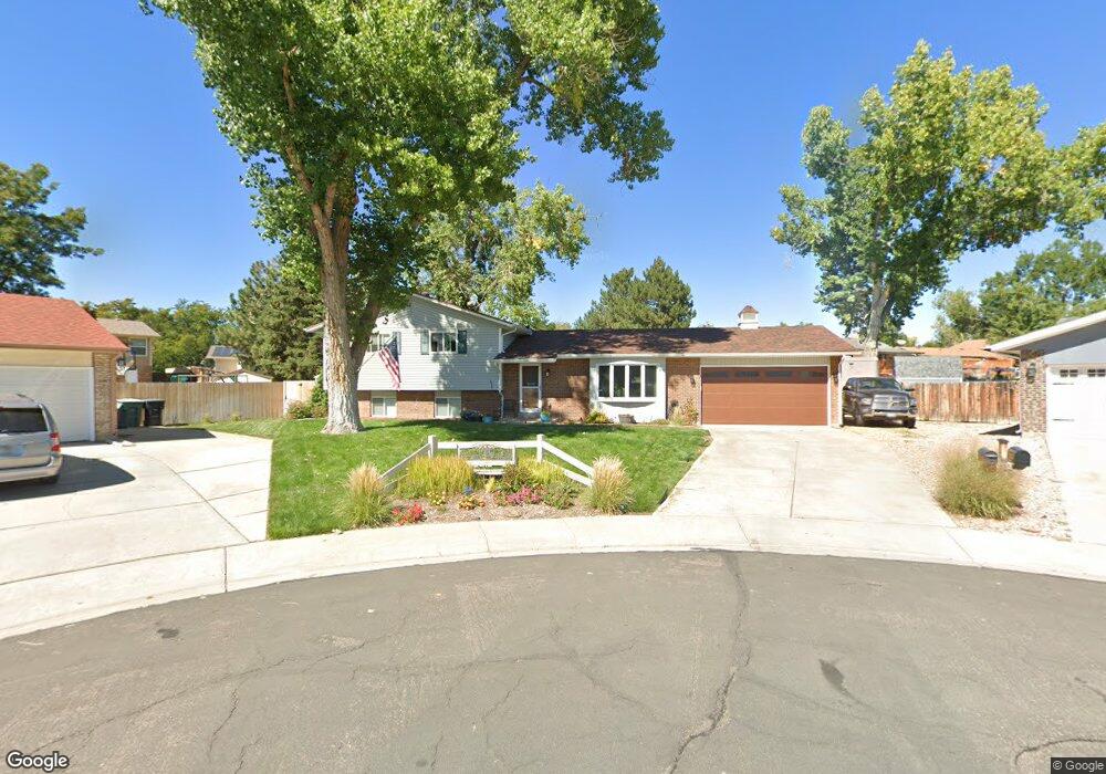
13165 Monroe Ct Thornton, CO 80241
Cottonwood Lakes NeighborhoodEstimated Value: $518,000 - $549,000
4
Beds
3
Baths
2,474
Sq Ft
$213/Sq Ft
Est. Value
About This Home
This home is located at 13165 Monroe Ct, Thornton, CO 80241 and is currently estimated at $527,970, approximately $213 per square foot. 13165 Monroe Ct is a home located in Adams County with nearby schools including Tarver Elementary School, Century Middle School, and Horizon High School.
Ownership History
Date
Name
Owned For
Owner Type
Purchase Details
Closed on
Jan 6, 2015
Sold by
Gettman Hollie Camille
Bought by
Houle Hollie Camille and Houle Brad Alexander
Current Estimated Value
Purchase Details
Closed on
Dec 20, 2013
Sold by
Giron Richard C and Giron Bernadette T
Bought by
Gettman Hollie Camille
Home Financials for this Owner
Home Financials are based on the most recent Mortgage that was taken out on this home.
Original Mortgage
$219,925
Interest Rate
4.21%
Mortgage Type
New Conventional
Create a Home Valuation Report for This Property
The Home Valuation Report is an in-depth analysis detailing your home's value as well as a comparison with similar homes in the area
Home Values in the Area
Average Home Value in this Area
Purchase History
| Date | Buyer | Sale Price | Title Company |
|---|---|---|---|
| Houle Hollie Camille | -- | None Available | |
| Gettman Hollie Camille | $231,500 | Homestead Title & Escrow |
Source: Public Records
Mortgage History
| Date | Status | Borrower | Loan Amount |
|---|---|---|---|
| Previous Owner | Gettman Hollie Camille | $219,925 |
Source: Public Records
Tax History Compared to Growth
Tax History
| Year | Tax Paid | Tax Assessment Tax Assessment Total Assessment is a certain percentage of the fair market value that is determined by local assessors to be the total taxable value of land and additions on the property. | Land | Improvement |
|---|---|---|---|---|
| 2024 | $3,289 | $31,690 | $6,560 | $25,130 |
| 2023 | $3,256 | $36,870 | $6,770 | $30,100 |
| 2022 | $2,773 | $25,170 | $6,460 | $18,710 |
| 2021 | $2,866 | $25,170 | $6,460 | $18,710 |
| 2020 | $2,496 | $22,370 | $6,650 | $15,720 |
| 2019 | $2,501 | $22,370 | $6,650 | $15,720 |
| 2018 | $2,415 | $20,990 | $7,490 | $13,500 |
| 2017 | $2,196 | $20,990 | $7,490 | $13,500 |
| 2016 | $1,685 | $15,680 | $3,660 | $12,020 |
| 2015 | $1,683 | $15,680 | $3,660 | $12,020 |
| 2014 | -- | $16,220 | $3,420 | $12,800 |
Source: Public Records
Map
Nearby Homes
- 3163 E 133rd Ave
- 3681 E 133rd Cir
- 13186 Fillmore St
- 13068 Harrison Dr
- 12890 Jackson Cir
- 4061 E 133rd Cir
- 2691 E 132nd Ave
- 2882 Signal Creek Dr
- 3560 E 128th Place
- 13277 Elizabeth St
- 13349 Albion Cir
- 13540 Detroit St
- 13118 Ash St
- 2746 E 132nd Place
- 13317 Albion Cir
- 3750 E 135th Dr
- 13575 Garfield Way
- 13022 Bellaire St
- 13102 Bellaire Dr
- 12865 Clermont St
- 13155 Monroe Ct
- 13162 Monroe Ct
- 13174 Saint Paul Dr
- 13176 Saint Paul Dr
- 13172 Saint Paul Dr
- 13170 Saint Paul Dr
- 13152 Monroe Ct
- 13145 Monroe Ct
- 13168 Saint Paul Dr
- 13161 Garfield Dr
- 13151 Garfield Dr
- 13142 Monroe Ct
- 13178 Saint Paul Dr
- 13166 Saint Paul Dr
- 13135 Monroe Ct
- 13141 Garfield Dr
- 13185 Saint Paul Dr
- 13183 Saint Paul Dr
- 13131 Garfield Dr
- 13132 Monroe Ct