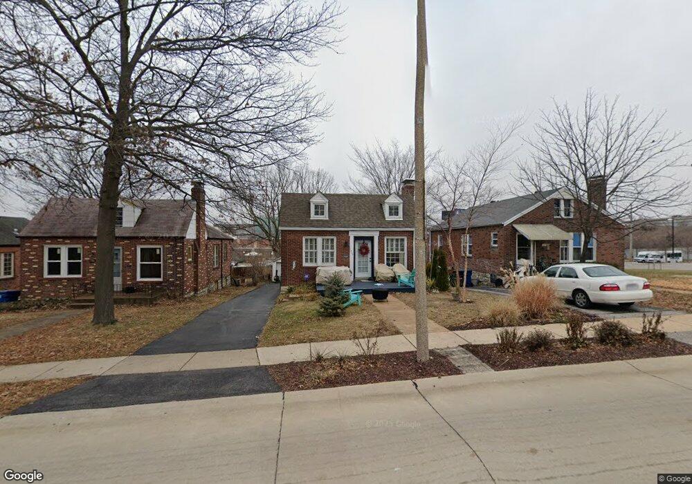
1317 Laclede Station Rd Saint Louis, MO 63117
Estimated Value: $282,586 - $369,000
3
Beds
1
Bath
1,248
Sq Ft
$253/Sq Ft
Est. Value
About This Home
This home is located at 1317 Laclede Station Rd, Saint Louis, MO 63117 and is currently estimated at $316,147, approximately $253 per square foot. 1317 Laclede Station Rd is a home located in St. Louis County with nearby schools including Maplewood Richmond Heights Elementary School, Maplewood Richmond Heights Middle School, and Maplewood-Richmond Heights High School.
Ownership History
Date
Name
Owned For
Owner Type
Purchase Details
Closed on
Nov 6, 1998
Sold by
Metze David M and Metze Cristin C
Bought by
Ecker Mary L
Current Estimated Value
Home Financials for this Owner
Home Financials are based on the most recent Mortgage that was taken out on this home.
Original Mortgage
$88,000
Outstanding Balance
$19,141
Interest Rate
6.55%
Estimated Equity
$297,006
Create a Home Valuation Report for This Property
The Home Valuation Report is an in-depth analysis detailing your home's value as well as a comparison with similar homes in the area
Home Values in the Area
Average Home Value in this Area
Purchase History
| Date | Buyer | Sale Price | Title Company |
|---|---|---|---|
| Ecker Mary L | $93,000 | Capital Title |
Source: Public Records
Mortgage History
| Date | Status | Borrower | Loan Amount |
|---|---|---|---|
| Open | Ecker Mary L | $88,000 |
Source: Public Records
Tax History Compared to Growth
Tax History
| Year | Tax Paid | Tax Assessment Tax Assessment Total Assessment is a certain percentage of the fair market value that is determined by local assessors to be the total taxable value of land and additions on the property. | Land | Improvement |
|---|---|---|---|---|
| 2025 | $3,274 | $54,870 | $29,490 | $25,380 |
| 2024 | $3,274 | $42,560 | $18,370 | $24,190 |
| 2023 | $3,245 | $42,560 | $18,370 | $24,190 |
| 2022 | $3,120 | $37,860 | $18,370 | $19,490 |
| 2021 | $3,066 | $37,860 | $18,370 | $19,490 |
| 2020 | $2,898 | $33,910 | $15,730 | $18,180 |
| 2019 | $2,876 | $33,910 | $15,730 | $18,180 |
| 2018 | $2,489 | $26,580 | $10,370 | $16,210 |
| 2017 | $2,472 | $26,580 | $10,370 | $16,210 |
| 2016 | $2,287 | $23,690 | $9,520 | $14,170 |
| 2015 | $2,150 | $23,690 | $9,520 | $14,170 |
| 2014 | $2,045 | $22,590 | $5,340 | $17,250 |
Source: Public Records
Map
Nearby Homes
- 7735 Saint Albans Ave
- 1501 Stockard Ave
- 7716 Lovella Ave
- 7723 Dale Ave
- 7715 Dale Ave
- 1510 Banneker Ave
- 1250 Hampton Park Dr
- 7718 W Ranken Ave
- 7765 Weston Place
- 1262 Moorlands Dr
- 7742 Wise Ave
- 1241 Strassner Dr Unit 1308
- 1270 Strassner Dr Unit 3110
- 1140 Hillside Dr
- 61 Lake Forest Dr
- 1174 Claytonia Terrace
- 1723 Mccready Ave
- 2030 Bland Place
- 7590 W Bruno Ave
- 1123 Claytonia Terrace
- 1315 Laclede Station Rd
- 1319 Laclede Station Rd
- 1321 Laclede Station Rd
- 1313 Laclede Station Rd
- 1309 Laclede Station Rd
- 1327 Laclede Station Rd
- 1303 Laclede Station Rd
- 7912 Dale Ave
- 7916 Dale Ave
- 7918 Dale Ave
- 7922 Dale Ave
- 7926 Dale Ave
- 1441 Laclede Station Rd
- 7930 Dale Ave
- 1325 Boland Place
- 1325 Boland Place
- 1443 Laclede Station Rd
- 7768 Dale Ave
- 7932 Dale Ave
- 7905 Hicks Ave