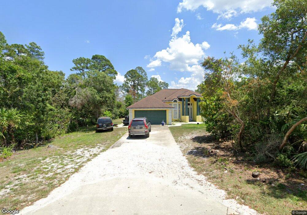
1317 Michael Ave Deltona, FL 32738
Estimated Value: $358,000 - $497,666
4
Beds
2
Baths
2,507
Sq Ft
$167/Sq Ft
Est. Value
About This Home
This home is located at 1317 Michael Ave, Deltona, FL 32738 and is currently estimated at $418,417, approximately $166 per square foot. 1317 Michael Ave is a home with nearby schools including Deltona Lakes Elementary School, Heritage Middle School, and Pine Ridge High School.
Ownership History
Date
Name
Owned For
Owner Type
Purchase Details
Closed on
Sep 26, 2022
Sold by
Scotland Iris L Le
Bought by
Benzo Felicia A and Scotland Iris L
Current Estimated Value
Purchase Details
Closed on
Jan 11, 1995
Sold by
Scotland Dom and Scotland Bernadette
Bought by
Scotland Iris
Home Financials for this Owner
Home Financials are based on the most recent Mortgage that was taken out on this home.
Original Mortgage
$132,000
Interest Rate
9.14%
Purchase Details
Closed on
Sep 15, 1988
Bought by
Scotland Iris
Create a Home Valuation Report for This Property
The Home Valuation Report is an in-depth analysis detailing your home's value as well as a comparison with similar homes in the area
Home Values in the Area
Average Home Value in this Area
Purchase History
| Date | Buyer | Sale Price | Title Company |
|---|---|---|---|
| Benzo Felicia A | -- | -- | |
| Scotland Iris | -- | -- | |
| Scotland Iris | $65,000 | -- |
Source: Public Records
Mortgage History
| Date | Status | Borrower | Loan Amount |
|---|---|---|---|
| Previous Owner | Scotland Iris | $132,000 |
Source: Public Records
Tax History
| Year | Tax Paid | Tax Assessment Tax Assessment Total Assessment is a certain percentage of the fair market value that is determined by local assessors to be the total taxable value of land and additions on the property. | Land | Improvement |
|---|---|---|---|---|
| 2026 | $2,658 | $161,261 | -- | -- |
| 2025 | $2,658 | $161,261 | -- | -- |
| 2024 | $2,470 | $156,718 | -- | -- |
| 2023 | $2,470 | $152,153 | $0 | $0 |
| 2022 | $2,438 | $147,721 | $0 | $0 |
| 2021 | $2,495 | $143,418 | $0 | $0 |
| 2020 | $2,460 | $141,438 | $0 | $0 |
| 2019 | $2,482 | $138,258 | $0 | $0 |
| 2018 | $2,459 | $135,680 | $0 | $0 |
| 2017 | $2,442 | $132,889 | $0 | $0 |
| 2016 | $2,358 | $130,156 | $0 | $0 |
| 2015 | $2,400 | $129,251 | $0 | $0 |
| 2014 | $2,379 | $128,225 | $0 | $0 |
Source: Public Records
Map
Nearby Homes
- 1301 Worthington Dr
- 1951 Beacon St
- 1389 Worthington Dr
- 1911 Beacon St
- 1961 Paragon St
- 1981 S Merrick Dr
- 1501 Fort Smith Blvd
- 1911 Stanton St
- 1456 Helena Ct
- 0 Melshire Ave Unit MFRO6380324
- 1518 Daroca Dr
- 1762 Philadelphia Ct
- 1106 Swanson Dr
- 1542 Fort Smith Blvd
- 2200 Wallingford St
- 1370 Pacific Ct
- 1431 Quintara Ave
- 1749 Haverhill Dr
- 1656 Gregory Dr
- 1502 Daroca Dr
- 1309 Michael Ave
- 1357 Worthington Dr
- 1365 Worthington Dr
- 1349 Worthington Dr
- 1373 Worthington Dr
- 1341 Worthington Dr
- 1381 Worthington Dr
- 1325 Worthington Dr
- 1364 Worthington Dr
- 1961 N Portillo Dr
- 1336 Worthington Dr
- 1382 Worthington Dr
- 1317 Worthington Dr
- 1328 Worthington Dr
- 1952 N Worthington Dr Unit 16
- 1952 N Portillo Dr
- 2043 Watersedge Dr
- 1299 Michael Ave
- 1951 N Portillo Dr
Your Personal Tour Guide
Ask me questions while you tour the home.