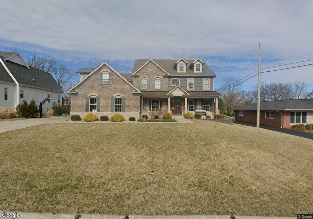
1318 Marlann Dr Saint Louis, MO 63131
Estimated Value: $1,372,000 - $2,123,000
4
Beds
5
Baths
5,186
Sq Ft
$318/Sq Ft
Est. Value
About This Home
This home is located at 1318 Marlann Dr, Saint Louis, MO 63131 and is currently estimated at $1,650,734, approximately $318 per square foot. 1318 Marlann Dr is a home located in St. Louis County with nearby schools including Westchester Elementary School, North Kirkwood Middle School, and Kirkwood Senior High School.
Ownership History
Date
Name
Owned For
Owner Type
Purchase Details
Closed on
Sep 20, 2019
Sold by
Hietter James E and Hietter Patricia A
Bought by
Hietter James Edward and Hietter Patricia Ann
Current Estimated Value
Purchase Details
Closed on
Sep 4, 2015
Sold by
The Revocable Living Trust Agreement Of
Bought by
Hietter James E and Hietter Patricia A
Create a Home Valuation Report for This Property
The Home Valuation Report is an in-depth analysis detailing your home's value as well as a comparison with similar homes in the area
Home Values in the Area
Average Home Value in this Area
Purchase History
| Date | Buyer | Sale Price | Title Company |
|---|---|---|---|
| Hietter James Edward | -- | None Available | |
| Hietter James E | $285,000 | Vision Title Llc |
Source: Public Records
Tax History Compared to Growth
Tax History
| Year | Tax Paid | Tax Assessment Tax Assessment Total Assessment is a certain percentage of the fair market value that is determined by local assessors to be the total taxable value of land and additions on the property. | Land | Improvement |
|---|---|---|---|---|
| 2025 | $12,263 | $258,590 | $70,320 | $188,270 |
| 2024 | $12,263 | $212,460 | $52,500 | $159,960 |
| 2023 | $12,263 | $212,460 | $52,500 | $159,960 |
| 2022 | $11,264 | $184,760 | $52,500 | $132,260 |
| 2021 | $11,143 | $184,760 | $52,500 | $132,260 |
| 2020 | $11,171 | $178,090 | $48,450 | $129,640 |
| 2019 | $11,185 | $178,090 | $48,450 | $129,640 |
| 2018 | $9,989 | $142,670 | $27,230 | $115,440 |
| 2017 | $1,906 | $27,230 | $27,230 | $0 |
| 2016 | $3,949 | $56,740 | $23,430 | $33,310 |
| 2015 | $3,954 | $56,740 | $23,430 | $33,310 |
| 2014 | $3,754 | $52,630 | $10,600 | $42,030 |
Source: Public Records
Map
Nearby Homes
- 1126 Bopp Rd
- 8 Briarbrook Trail
- 1345 Woodgate Dr
- 1090 Kinstern Dr
- 1029 Kinstern Dr
- 723 Oak Valley Dr
- 811 Cherry St
- 1728 Folkstone Dr
- 1741 Pine Hill Dr
- 11909 Lillian Ave
- 11913 Lillian Ave
- 12006 Montour Dr
- 918 N Ballas Rd
- 1001 Dovergate Dr
- 12439 Springdale Ln Unit TBB
- 11358 Manchester Rd
- 12224 TBB Roger Ln
- The Hawthorne Plan at Ballas Ridge
- The Roclare II Plan at Ballas Ridge
- The Westchester IV Plan at Ballas Ridge
- 1326 Marlann Dr
- 1310 Marlann Dr
- 11928 Hargrove Dr
- 11920 Hargrove Dr
- 1317 Marlann Dr
- 1300 Marlann Dr
- 1325 Marlann Dr
- 11901 Bayberry Ln
- 11944 Hargrove Dr
- 11912 Hargrove Dr
- 1333 Marlann Dr
- 11931 Hargrove Dr
- 11841 Bayberry Ln
- 11939 Hargrove Dr
- 11923 Hargrove Dr
- 11827 Bayberry Ln
- 1341 Marlann Dr
- 11915 Bayberry Ln
- 1400 Marlann Dr
- 1308 Bopp Rd