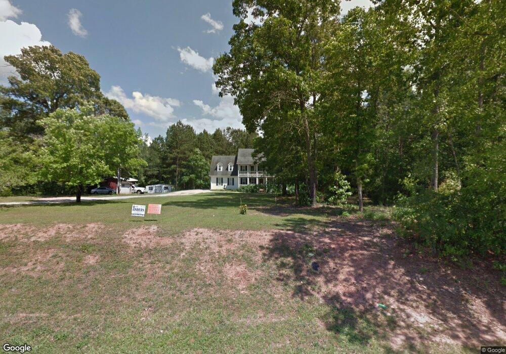
1318 Smokey Rd Newnan, GA 30263
Estimated Value: $489,966 - $553,000
4
Beds
4
Baths
2,826
Sq Ft
$185/Sq Ft
Est. Value
About This Home
This home is located at 1318 Smokey Rd, Newnan, GA 30263 and is currently estimated at $522,242, approximately $184 per square foot. 1318 Smokey Rd is a home located in Coweta County with nearby schools including Ruth Hill Elementary School, Smokey Road Middle School, and Newnan High School.
Ownership History
Date
Name
Owned For
Owner Type
Purchase Details
Closed on
Dec 21, 2006
Sold by
Mcguffey James E and Mcguffey Nancy W
Bought by
Mcguffey Michael R and Mcguffey Leigh T
Current Estimated Value
Purchase Details
Closed on
Dec 14, 2000
Sold by
Robards Cheryl D
Bought by
Mcguffey James E
Purchase Details
Closed on
Dec 13, 2000
Sold by
Duke Mary Payne Estate
Bought by
Robards Cheryl D
Purchase Details
Closed on
Jul 7, 2000
Sold by
Duke Mary P Estate
Bought by
Duke Mary Payne Estate
Purchase Details
Closed on
Nov 30, 1992
Bought by
Duke Mary P Estate
Create a Home Valuation Report for This Property
The Home Valuation Report is an in-depth analysis detailing your home's value as well as a comparison with similar homes in the area
Home Values in the Area
Average Home Value in this Area
Purchase History
| Date | Buyer | Sale Price | Title Company |
|---|---|---|---|
| Mcguffey Michael R | -- | -- | |
| Mcguffey James E | $111,000 | -- | |
| Robards Cheryl D | $25,000 | -- | |
| Duke Mary Payne Estate | -- | -- | |
| Duke Mary P Estate | -- | -- |
Source: Public Records
Tax History Compared to Growth
Tax History
| Year | Tax Paid | Tax Assessment Tax Assessment Total Assessment is a certain percentage of the fair market value that is determined by local assessors to be the total taxable value of land and additions on the property. | Land | Improvement |
|---|---|---|---|---|
| 2024 | $3,484 | $154,680 | $14,039 | $140,640 |
| 2023 | $3,484 | $159,905 | $16,297 | $143,608 |
| 2022 | $2,878 | $121,526 | $10,864 | $110,662 |
| 2021 | $2,904 | $114,985 | $10,347 | $104,638 |
| 2020 | $3,047 | $114,985 | $10,347 | $104,638 |
| 2019 | $2,712 | $92,645 | $11,814 | $80,831 |
| 2018 | $2,716 | $92,645 | $11,814 | $80,831 |
| 2017 | $2,594 | $88,502 | $11,814 | $76,688 |
| 2016 | $2,563 | $88,502 | $11,814 | $76,688 |
| 2015 | $2,520 | $88,502 | $11,814 | $76,688 |
| 2014 | $2,499 | $88,502 | $11,814 | $76,688 |
Source: Public Records
Map
Nearby Homes
- 56 Fox Hollow Run
- 15 Forest Place
- 68 Timberland Trail
- 50 Hearthstone Dr
- 1845 Smokey Rd
- 713 Smokey Rd
- 130 Mallard Dr
- 150 Wild Boar Way
- 0 George Arnold Rd Unit 7657652
- 0 George Arnold Rd Unit 10617612
- 623 Belk Rd
- 75 Davis McLendon Way
- 0 Meadowsweet Ln Unit 10582479
- 31 Festiva Dr
- 140 Beverly Park Ct
- 130 Wallace Gray Cir
- 135 Widgeon Dr
- 124 Wallace Gray Cir
- 0 Smokey Rd Unit 10495165
- 0 Walt Sanders Rd Unit 10607560
- 1254 Smokey Rd
- 52 Fox Hollow Run
- 52 Fox Hollow Run Unit 13.68 AC
- 5 O Dell Ridge
- 34 Fox Hollow Run
- 1277 Smokey Rd
- 0 Strickland Pond Rd Unit 8324217
- 0 Strickland Pond Rd Unit 8299861
- 0 Strickland Pond Rd Unit 7171075
- 0 Strickland Pond Rd Unit LOT 6 7309554
- 0 Strickland Pond Rd Unit LOT 5 7309550
- 0 Strickland Pond Rd Unit LOT 4 7309546
- 0 Strickland Pond Rd Unit LOT 3 7309525
- 0 Strickland Pond Rd Unit LOT 2 7309520
- 0 Strickland Pond Rd Unit LOT 1 7308750
- 0 Strickland Pond Rd Unit 30 ACRES 7336288
- 0 Strickland Pond Rd Unit 3239371
- 0 Strickland Pond Rd Unit 7024553
- 0 Strickland Pond Rd Unit 7089013
- 0 Strickland Pond Rd Unit 7482422