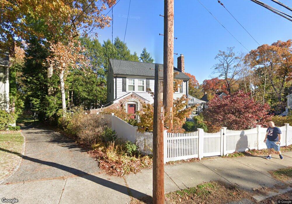
1318 Walnut St Newton Highlands, MA 02461
Newton Highlands NeighborhoodEstimated Value: $1,007,000 - $1,274,564
3
Beds
2
Baths
1,488
Sq Ft
$798/Sq Ft
Est. Value
About This Home
This home is located at 1318 Walnut St, Newton Highlands, MA 02461 and is currently estimated at $1,187,891, approximately $798 per square foot. 1318 Walnut St is a home located in Middlesex County with nearby schools including Countryside Elementary School, Charles E Brown Middle School, and Newton South High School.
Ownership History
Date
Name
Owned For
Owner Type
Purchase Details
Closed on
Dec 8, 2014
Sold by
Finn Cark S
Bought by
Finn Christine and Finn Carl S
Current Estimated Value
Home Financials for this Owner
Home Financials are based on the most recent Mortgage that was taken out on this home.
Original Mortgage
$245,000
Outstanding Balance
$190,616
Interest Rate
3.93%
Mortgage Type
New Conventional
Estimated Equity
$997,275
Purchase Details
Closed on
Jun 10, 1987
Sold by
Cohen Edith L
Bought by
Finn Carl S
Create a Home Valuation Report for This Property
The Home Valuation Report is an in-depth analysis detailing your home's value as well as a comparison with similar homes in the area
Home Values in the Area
Average Home Value in this Area
Purchase History
| Date | Buyer | Sale Price | Title Company |
|---|---|---|---|
| Finn Christine | -- | -- | |
| Finn Carl S | $307,000 | -- |
Source: Public Records
Mortgage History
| Date | Status | Borrower | Loan Amount |
|---|---|---|---|
| Open | Finn Christine | $245,000 | |
| Previous Owner | Finn Carl S | $134,000 | |
| Previous Owner | Finn Carl S | $30,000 | |
| Previous Owner | Finn Carl S | $225,000 |
Source: Public Records
Tax History Compared to Growth
Tax History
| Year | Tax Paid | Tax Assessment Tax Assessment Total Assessment is a certain percentage of the fair market value that is determined by local assessors to be the total taxable value of land and additions on the property. | Land | Improvement |
|---|---|---|---|---|
| 2025 | $9,914 | $1,011,600 | $884,600 | $127,000 |
| 2024 | $9,585 | $982,100 | $858,800 | $123,300 |
| 2023 | $9,104 | $894,300 | $653,000 | $241,300 |
| 2022 | $8,712 | $828,100 | $604,600 | $223,500 |
| 2021 | $8,406 | $781,200 | $570,400 | $210,800 |
| 2020 | $8,156 | $781,200 | $570,400 | $210,800 |
| 2019 | $7,925 | $758,400 | $553,800 | $204,600 |
| 2018 | $7,525 | $695,500 | $502,200 | $193,300 |
| 2017 | $7,296 | $656,100 | $473,800 | $182,300 |
| 2016 | $6,978 | $613,200 | $442,800 | $170,400 |
| 2015 | $6,654 | $573,100 | $413,800 | $159,300 |
Source: Public Records
Map
Nearby Homes
- 1308 Walnut St
- 1292 Walnut St
- 125 Oakdale Rd
- 1629 Centre St
- 1623-1625 Centre St
- 671 Boylston St
- 250 Woodcliff Rd
- 1597 Centre St Unit 1597
- 1597 Centre St
- 116 Upland Ave
- 19 Selwyn Rd
- 628 Boylston St
- 625 Boylston St
- 42 Sunhill Ln
- 36 Cannon St
- 1151 Walnut St Unit 205
- 1151 Walnut St Unit 405
- 1151 Walnut St Unit 207
- 21 Philbrick Rd
- 3 Glenmore Terrace Unit 2