Estimated Value: $62,000 - $100,000
3
Beds
1
Bath
1,368
Sq Ft
$61/Sq Ft
Est. Value
About This Home
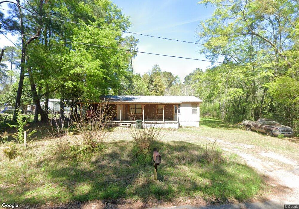
This home is located at 1319 10th Ave NE, Cairo, GA 39828 and is currently estimated at $83,799, approximately $61 per square foot. 1319 10th Ave NE is a home located in Grady County with nearby schools including Cairo High School.
Ownership History
Date
Name
Owned For
Owner Type
Purchase Details
Closed on
Oct 10, 2019
Sold by
Heaberlin Rodger
Bought by
Heaberlin Matthew Scott
Current Estimated Value
Purchase Details
Closed on
Jan 19, 2005
Bought by
Heaberlin Rodger
Purchase Details
Closed on
Sep 23, 2004
Sold by
Vicks Willie Lee
Bought by
W M Specialty Mortgage
Purchase Details
Closed on
Jul 7, 1999
Sold by
Vicks Willie Lee
Bought by
Vicks Willie Lee
Purchase Details
Closed on
Oct 14, 1996
Sold by
Rutland Ronald
Bought by
Vicks Willie Lee
Purchase Details
Closed on
Mar 4, 1967
Bought by
Rutland Ronald
Create a Home Valuation Report for This Property
The Home Valuation Report is an in-depth analysis detailing your home's value as well as a comparison with similar homes in the area
Home Values in the Area
Average Home Value in this Area
Purchase History
| Date | Buyer | Sale Price | Title Company |
|---|---|---|---|
| Heaberlin Matthew Scott | $33,750 | -- | |
| Heaberlin Rodger | $15,000 | -- | |
| W M Specialty Mortgage | -- | -- | |
| Vicks Willie Lee | -- | -- | |
| Vicks Willie Lee | $15,000 | -- | |
| Rutland Ronald | -- | -- |
Source: Public Records
Tax History Compared to Growth
Tax History
| Year | Tax Paid | Tax Assessment Tax Assessment Total Assessment is a certain percentage of the fair market value that is determined by local assessors to be the total taxable value of land and additions on the property. | Land | Improvement |
|---|---|---|---|---|
| 2024 | $1,026 | $26,017 | $2,320 | $23,697 |
| 2023 | $454 | $12,278 | $1,498 | $10,780 |
| 2022 | $473 | $12,278 | $1,498 | $10,780 |
| 2021 | $474 | $12,278 | $1,498 | $10,780 |
| 2020 | $475 | $12,278 | $1,498 | $10,780 |
| 2019 | $475 | $12,278 | $1,498 | $10,780 |
| 2018 | $452 | $12,278 | $1,498 | $10,780 |
| 2017 | $434 | $12,278 | $1,498 | $10,780 |
| 2016 | $373 | $10,298 | $1,498 | $8,800 |
| 2015 | $369 | $10,298 | $1,498 | $8,800 |
| 2014 | $369 | $10,298 | $1,498 | $8,800 |
| 2013 | -- | $9,087 | $1,497 | $7,590 |
Source: Public Records
Map
Nearby Homes
- 00 NW 9th Ave
- 0 20th St NE
- 00 20th St NE
- 711 2nd Ave NE
- Lot #15, 3 64 Acres Oakbend Cir
- 2975 U S 84
- 66 22nd St NE
- 4761 Hadley Ferry Rd
- 00 State Route 188
- 0 State Route 188
- 309 3rd St SE
- 471 4th St SE
- 21 24th St NE
- 481 4th St SE
- 2600 U S 84
- 125 6th Ave NW
- X 1st St
- 00 Hwy 111 South Tract 1
- 316,322 NW 1st St + Lot
- 0 1st St
- 1020 13th St NE
- 970 13th St NE
- 1050 13th St NE
- 1001 13th St NE
- 1345 9th Ave NE
- 1291 Tired Creek Blvd
- 918 13th St NE
- 1060 13th St NE
- 1397 9th Ave NE
- 1370 10th Ave NE
- 1388 9th Ave NE
- 1238 Tired Creek Blvd
- 1380 9th Ave NE
- 1351 Tired Creek Blvd
- 1394 9th Ave NE
- 1193 Tired Creek Blvd
- 1393 Tired Creek Blvd
- 1190 Tired Creek Blvd
- 875 12th St NE
- 865 12th St NE