Estimated Value: $212,000 - $234,000
3
Beds
1
Bath
1,040
Sq Ft
$215/Sq Ft
Est. Value
About This Home
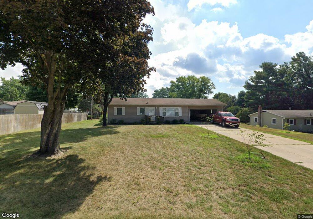
This home is located at 1319 Cedarhurst Rd, Niles, MI 49120 and is currently estimated at $224,053, approximately $215 per square foot. 1319 Cedarhurst Rd is a home located in Cass County with nearby schools including James Ellis School, Howard-Ellis Elementary School, and Ring Lardner Middle School.
Ownership History
Date
Name
Owned For
Owner Type
Purchase Details
Closed on
May 5, 2025
Sold by
Yoder Keith J
Bought by
Yoder Keith J and Smith Karianne
Current Estimated Value
Purchase Details
Closed on
Jul 26, 2024
Sold by
Myer Dale E and Myer Tara
Bought by
Yoder Keith J
Home Financials for this Owner
Home Financials are based on the most recent Mortgage that was taken out on this home.
Original Mortgage
$9,609
Interest Rate
9.5%
Create a Home Valuation Report for This Property
The Home Valuation Report is an in-depth analysis detailing your home's value as well as a comparison with similar homes in the area
Home Values in the Area
Average Home Value in this Area
Purchase History
| Date | Buyer | Sale Price | Title Company |
|---|---|---|---|
| Yoder Keith J | -- | None Listed On Document | |
| Yoder Keith J | -- | None Listed On Document | |
| Yoder Keith J | $208,000 | None Listed On Document | |
| Yoder Keith J | $208,000 | None Listed On Document |
Source: Public Records
Mortgage History
| Date | Status | Borrower | Loan Amount |
|---|---|---|---|
| Previous Owner | Yoder Keith J | $9,609 | |
| Previous Owner | Yoder Keith J | $201,760 |
Source: Public Records
Tax History
| Year | Tax Paid | Tax Assessment Tax Assessment Total Assessment is a certain percentage of the fair market value that is determined by local assessors to be the total taxable value of land and additions on the property. | Land | Improvement |
|---|---|---|---|---|
| 2025 | $1,472 | $85,800 | $85,800 | $0 |
| 2024 | $580 | $73,300 | $73,300 | $0 |
| 2023 | $553 | $93,500 | $0 | $0 |
| 2022 | $526 | $55,100 | $0 | $0 |
| 2021 | $1,199 | $54,400 | $0 | $0 |
| 2020 | $1,187 | $51,800 | $0 | $0 |
| 2019 | $1,145 | $46,200 | $0 | $0 |
| 2018 | $501 | $46,600 | $0 | $0 |
| 2017 | $494 | $50,100 | $0 | $0 |
| 2016 | $490 | $48,460 | $0 | $0 |
| 2015 | -- | $50,600 | $0 | $0 |
| 2011 | -- | $47,600 | $0 | $0 |
Source: Public Records
Map
Nearby Homes
- 2582 Bartak St
- 2671 Mulberry St
- 1403 Barron Lake Rd
- 2561 Lake Shore Dr
- 2529 Lake Shore Dr
- 0 Lake St Unit 25037542
- 1943 Terminal Rd
- 2314 Hand Rd
- 2354 Yankee St
- 1718 Barron Lake Rd
- 2963 Detroit Rd
- 2298 Yankee St
- 851 Mobile Blvd Unit 4
- 1002 Leet Rd
- 2029 Catalina Dr
- 607 N 18th St
- 570 Invicta Dr
- 2451 Spansail Dr
- 1317 Cedarhurst Rd
- 2566 Douer St
- 2570 Douer St
- 1318 Cedarhurst Rd
- 1318 Cedarhurst Rd
- 1318 Cedarhurst Rd
- 1318 Norwood Rd
- 2508 Douer St
- 1316 Norwood Rd
- 1320 Cedarhurst Rd
- 2572 Douer St
- 1322 Cedarhurst Rd
- V/L Cedarhurst Rd
- 0 Cedarhurst Rd
- 1313 Cedarhurst Rd
- 1313 Cedarhurst Rd
- 1312 Norwood Rd
- 2565 Douer St
- 2567 Douer St
- 1312 Cedarhurst Rd
Your Personal Tour Guide
Ask me questions while you tour the home.