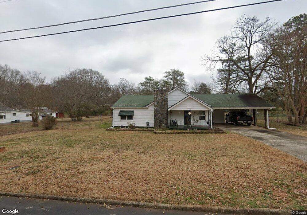
132 4th Ave Griffin, GA 30223
Spalding County NeighborhoodEstimated Value: $129,000 - $194,000
2
Beds
1
Bath
1,148
Sq Ft
$130/Sq Ft
Est. Value
About This Home
This home is located at 132 4th Ave, Griffin, GA 30223 and is currently estimated at $149,441, approximately $130 per square foot. 132 4th Ave is a home located in Spalding County with nearby schools including Cowan Road Elementary School, Cowan Road Middle School, and Griffin High School.
Ownership History
Date
Name
Owned For
Owner Type
Purchase Details
Closed on
Aug 19, 1975
Sold by
Hand David Wayne
Bought by
Martin David R and Martin Mattie J
Current Estimated Value
Purchase Details
Closed on
Feb 21, 1973
Sold by
Huckaby Larry A and Huckaby Marsha M
Bought by
Hand David W and Hand Sheila L
Purchase Details
Closed on
Mar 30, 1968
Sold by
Coleman H L
Bought by
Huckaby Larry A and Huckaby Marsha M
Purchase Details
Closed on
Jul 31, 1946
Bought by
Coleman H L
Create a Home Valuation Report for This Property
The Home Valuation Report is an in-depth analysis detailing your home's value as well as a comparison with similar homes in the area
Home Values in the Area
Average Home Value in this Area
Purchase History
| Date | Buyer | Sale Price | Title Company |
|---|---|---|---|
| Martin David R | -- | -- | |
| Hand David Wayne | -- | -- | |
| Hand David W | $15,800 | -- | |
| Huckaby Larry A | $8,000 | -- | |
| Coleman H L | -- | -- |
Source: Public Records
Tax History
| Year | Tax Paid | Tax Assessment Tax Assessment Total Assessment is a certain percentage of the fair market value that is determined by local assessors to be the total taxable value of land and additions on the property. | Land | Improvement |
|---|---|---|---|---|
| 2025 | $639 | $41,754 | $7,200 | $34,554 |
| 2024 | $640 | $41,754 | $7,200 | $34,554 |
| 2023 | $639 | $41,754 | $7,200 | $34,554 |
| 2022 | $566 | $37,079 | $6,000 | $31,079 |
| 2021 | $114 | $14,020 | $4,800 | $9,220 |
| 2020 | $115 | $14,020 | $4,800 | $9,220 |
| 2019 | $117 | $14,020 | $4,800 | $9,220 |
| 2018 | $101 | $13,242 | $4,800 | $8,442 |
| 2017 | $93 | $12,994 | $4,800 | $8,194 |
| 2016 | $94 | $12,994 | $4,800 | $8,194 |
| 2015 | $102 | $12,994 | $4,800 | $8,194 |
| 2014 | $102 | $12,994 | $4,800 | $8,194 |
Source: Public Records
Map
Nearby Homes
- 512 Terry Dr
- 1618 Morgan Dr
- 164 Crystal Brook
- 1607 Hallmark Hills Dr
- 1615 Hallmark Hills Dr
- 147 Crystal Brook
- 114 Waterford Way
- 1626 Hallmark Hills Dr
- 1710 Hallmark Dr
- 105 Wedgewood Walk
- 90 Crystal Brook
- 0 N Pine Hill Rd Unit 10465642
- 0 N Pine Hill Rd Unit 10465638
- 0 N Pine Hill Rd Unit 10465637
- 0 N Pine Hill Rd Unit 10465639
- 0 N Pine Hill Rd Unit 10465641
- 103 Sherbrooke Way
- 66 Ninety Two Place
- 517 N Pine Hill Rd
- 1705 Ridge St
Your Personal Tour Guide
Ask me questions while you tour the home.